Ehrenbach | |
|---|---|
 Ehrenbach  Ehrenbach | |
| Coordinates: 50°12′0″N 8°13′18″E / 50.20000°N 8.22167°E | |
| Country | Germany |
| State | Hesse |
| Admin. region | Darmstadt |
| District | Rheingau-Taunus-Kreis |
| Town | Idstein |
| Elevation | 349 m (1,145 ft) |
| Population (2021-12-31)
[1] | |
| • Total | 300 |
| Time zone | UTC+01:00 ( CET) |
| • Summer ( DST) | UTC+02:00 ( CEST) |
Ehrenbach is a village, first mentioned in 1371, that became in 1971 part of Idstein, Hesse, Germany.
Location
It is located southwest of Idstein in the Ehrenbach valley. The Upper Germanic-Rhaetian Limes borders it in the south. The highest point is the Scheid mountain (472 m high=, in the north-west. The district road ( Kreisstraße) K 707 connects Ehrenbach with the B 417 in the south-west and Idstein and the Bundesautobahn 3 in the north-east.
History
Ehrenbach was first mentioned in a document in 1371, as Ernbach. [2] A 1475 document ( Weistum) of the Auroffer Grund named Nassau-Idstein as ruler of two Ehrenbach. In 1566, the village had twelve households ( Hausgesess), and in 1609 ten households. [2]
In 1971, the independent village decided, together with two other settlements, to become part of Idstein. [3] The Stadtteil became a Ortsbezirk with elected representatives ( Ortsbeirat, headed by the Ortsvorsteher, according to the Hessische Gemeindeordnung. [4] Since 1977, Idstein has been part of the Rheingau-Taunus-Kreis. In 2011, the 2011 German census counted 291 inhabitants, 24 of them foreigners (8,2 %), living in 132 households. [5] [6]
Buildings
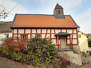
Ehrenbach features many timber-frame buildings. The Türmchen, serving as a Protestant church, was restored in 2020. A reconstructed Roman watch tower is part of the Kastell Zugmantel complex of the Limes World Heritage Site.
-
-
 Zugmantelstraße
 -
 Former school


References
- ^ "Zahlen-Daten-Fakten" (in German). Stadt Idstein. Retrieved 5 January 2023.
- ^ a b Ehrenbach, Rheingau-Taunus-Kreis. Historisches Ortslexikon für Hessen. In: Landesgeschichtliches Informationssystem Hessen (LAGIS). (Stand: 16 October 2018)
- ^ "Gemeindegebietsreform in Hessen: Zusammenschlüsse und Eingliederungen von Gemeinden" (PDF) (in German). Der Hessische Minister des Inneren. 21 June 1971. p. 5.
- ^ "Hauptsatzung" (PDF) (in German). Idstein. Retrieved 1 February 2019.
- ^ "Ausgewählte Daten über Bevölkerung und Haushalte am 9. Mai 2011 in den hessischen Gemeinden und Gemeindeteilen" (PDF). 2011 German census (in German). Hessisches Statistisches Landesamt. pp. 44, 98. Archived from the original (PDF) on 11 July 2021. Retrieved 31 December 2021.
- ^ "Zahlen-Daten-Fakten (aus Webarchiv)" (in German). Idtein. Archived from the original on 6 April 2016. Retrieved 31 December 2020.
External links
- Literatur Ehrenbach (in German) cbsopac.rz.uni-frankfurt.de
| Authority control databases: National |
|---|