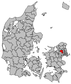
Egedal Municipality
Egedal Kommune (
Danish) | |
|---|---|
 City hall | |
 | |
| Coordinates: 55°46′07″N 12°12′46″E / 55.76861°N 12.21278°E | |
| Country | Denmark |
| Region | Hovedstaden |
| Established | 1 January 2007 |
| Seat | Ølstykke |
| Government | |
| • Mayor | Vicky Holst Rasmussen ( S) |
| Area | |
| • Total | 125.79 km2 (48.57 sq mi) |
| Population (1. January 2023)
[1] | |
| • Total | 45,202 |
| • Density | 360/km2 (930/sq mi) |
| Time zone | UTC+1 ( CET) |
| • Summer ( DST) | UTC+2 ( CEST) |
| Municipal code | 240 |
| Website |
www |
Egedal Municipality ( Danish: Egedal Kommune) is a municipality ( Danish, kommune) in Region Hovedstaden in Denmark. It covers an area of 125.79 km2 (48.57 sq mi) with a total population of 45,202 (1. January 2023).
History
On 1 January 2007 Egedal municipality was created as the result of Kommunalreformen ("The Municipal Reform" of 2007), consisting of the former municipalities of Ledøje-Smørum ( Copenhagen County), Ølstykke ( Frederiksborg County), and Stenløse ( Frederiksborg County).
Locations
| Ølstykke-Stenløse | 22,003 |
| Smørumnedre | 9,949 |
| Ganløse | 2,884 |
| Veksø | 1,799 |
| Slagslunde | 903 |
| Ledøje | 773 |
| Laanshøj | 597 |
| Tangbjerg | 597 |
| Buresø | 496 |
| Søsum | 312 |
Politics
Municipal council
Egedal's municipal council consists of 21 members, elected every four years.
Below are the municipal councils elected since the Municipal Reform of 2007.
| Election | Party | Total seats |
Turnout | Elected mayor | |||||||||
|---|---|---|---|---|---|---|---|---|---|---|---|---|---|
| A | B | C | E | F | I | O | V | ||||||
| 2005 | 5 | 1 | 8 | 2 | 1 | 10 | 27 | 77.1% | Svend Kjærgaard (V) | ||||
| 2009 | 4 | 1 | 6 | 1 | 3 | 1 | 5 | 21 | 73.7% | Willy Eliasen (V) | |||
| 2013 | 5 | 2 | 4 | 1 | 1 | 2 | 6 | 77.3% | |||||
| 2017 | 6 | 3 | 2 | 1 | 1 | 2 | 6 | 75.8% | Karsten Søndergaard (V) | ||||
| Data from Kmdvalg.dk 2005, 2009, 2013 and 2017 | |||||||||||||
References
- ^ BY2: Population 1. January by municipalities The Mobile Statbank from Statistics Denmark
- Municipal statistics: NetBorger Kommunefakta, delivered from KMD aka Kommunedata (Municipal Data)
- Municipal mergers and neighbors: Eniro new municipalities map
External links
Wikimedia Commons has media related to
Egedal Kommune.
-
 Egedal travel guide from Wikivoyage
 - The new Egedal Municipality's official website (Danish only)

