Edison | |
|---|---|
 Edison field, Racetrack Hill area, showing steam expansion loops and widely dispersed wells. | |
 Edison Location in California  Edison Edison (the United States) | |
| Coordinates: 35°20′51″N 118°52′18″W / 35.34750°N 118.87167°W | |
| Country | United States |
| State | California |
| County | Kern County |
| Elevation | 568 ft (173 m) |
| ZIP code | 93307
[2] |
| Area code | 661 |
Edison (formerly, Wade) [3] is an unincorporated community in the Tehachapi mountains of Kern County, California. [1] It is located 7.5 miles (12 km) east-southeast of downtown Bakersfield, [3] at an elevation of 568 feet (173 m). [1]
In 1902, the Edison Electric Company built a substation on the site. [3] The Southern Pacific Railroad arrived at Wade in 1903, and changed the name to Edison. [3] In 1928 oil was found nearby, and the Edison Oil Field gradually developed, peaking in the 1950s. The community is within the administrative boundaries of the oilfield, and active wells surround the town. [4] [5]
The Edison post office opened in 1903, closed in 1929, and re-opened in 1946. [3]
-
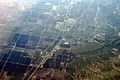 Aerial view of Edison from the east-northeast
 -
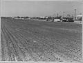 Potato farm in Edison, 1940


References
- ^ a b c U.S. Geological Survey Geographic Names Information System: Edison, California
- ^ "Edison CA ZIP Code". zipdatamaps.com. 2023. Retrieved February 17, 2023.
- ^ a b c d e Durham, David L. (1998). California's Geographic Names: A Gazetteer of Historic and Modern Names of the State. Clovis, Calif.: Word Dancer Press. p. 1031. ISBN 1-884995-14-4.
- ^ Kasline, Fred A. Edison Oil Field: California Division of Oil and Gas, Summary of Operations. 1940. Vol. 26 p 12-18
- ^ White, J. Lloyd. Edison Oil Field: California Division of Oil and Gas, Summary of Operations. 1955. Vol. 41 No. 2, p 5-9

|
| This Kern County, California-related article is a stub. You can help Wikipedia by expanding it. |