| Ed R. Levin County Park | |
|---|---|
 A view of the Ed R. Levin County Park and Sandy Wool Lake from Agua Caliente Trail | |
 Ed R. Levin County Park | |
| Type | landscape garden |
| Location | Milpitas, California |
| Coordinates | 37°28′00″N 121°51′25″W / 37.466604°N 121.856900°W [1] |
| Area | Santa Clara County Parks and Recreation Department |
| Operated by | Santa Clara County Parks and Recreation Department |

Ed R. Levin County Park is the largest park in Milpitas, California. It is run by the Santa Clara County Parks and Recreation Department and is located in the chaparral and grassland foothills of Diablo Range east of the Santa Clara Valley. Monument Peak can be accessed through trails in the park. The park's recreational facilities include a hang gliding and paragliding area, a dog park, and horseback riding areas. Ed R. Levin County Park has two lakes, Sandy Wool Lake and Spring Valley Pond. Both of them are reservoirs which collect runoff water from the hills to the east. It is home to some of the East Bay Walls. [2] The park is named after open space advocate and Santa Clara County 3rd District Supervisor Edgar R. Levin (1908-1965). [3]
Gallery
-
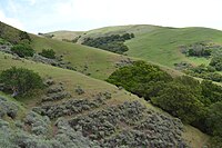 Diablo Range in the park
 -
 Hang gliding in the park
 -
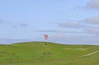 Paragliding in the park
 -
 A closer view of Sandy Wool Lake
 -
 Another view of Sandy Wool Lake and the dam which formed it
 -
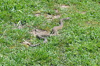 Rattlesnake in the park
 -
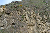 Exposed geological formation in the park


References
- ^ U.S. Geological Survey Geographic Names Information System: Ed R Levin Park
- ^ "Stone walls at Ed R. Levin County Park". 2007-07-11. Retrieved 2013-04-23.
- ^ "Ed and Ruby Levin Papers". oac.cdlib.org. Online Archives of California. Retrieved 7 June 2021.
External links
|
| This Santa Clara County, California-related article is a stub. You can help Wikipedia by expanding it. |