| Drury High School | |
|---|---|
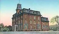
 1865 school building | |
| Address | |
|
| |
1130 South Church Street United States | |
| Information | |
| Type |
Public Open enrollment [1] |
| Established | 1843 |
| Status | Open |
| School district | North Adams Public Schools |
| Superintendent | Barbara Malkas |
| Principal | Stephanie Kopala |
| Staff | 46.56 (FTE) [2] |
| Grades | 7-12 |
| Age | 12 to 18 |
| Enrollment | 524 (2018–19) [2] |
| Student to teacher ratio | 11.25 [2] |
| Language | English |
| Color(s) | Blue and White |
| Athletics | Football, Baseball, Basketball, Bowling, Cheerleading, Cross-Country, Golf, Soccer, Softball, Track, and Co-op Sports, |
| Mascot | Blue Devil |
| Yearbook | Nathanite |
| Website |
drury |
Drury High School is a public school in North Adams, Massachusetts, United States. Part of the North Adams Public School District, it serves students in grades 7-12 from North Adams, and the towns of Clarksburg, Florida, and Monroe.
Current standing
Drury currently serves grades 7–12.
As of 2014, it had a student body of 459 students.
Drury competes primarily within Berkshire County, though a small portion of its non-league independent schedule includes similar-size schools from the Connecticut River Valley of Western Massachusetts and nearby Vermont.
One of two high schools in North Adams, Massachusetts ( Charles H. McCann Technical High School)
Most traditional rival is Hoosac Valley High School of Cheshire.[ citation needed]
Notable alumni
- Daniel E. Bosley, former member of the Massachusetts House of Representatives
- Gailanne M. Cariddi, former member of the Massachusetts House of Representatives
- Martha Coakley, former Massachusetts Attorney General
- William Evans (1980–2021), Class of 1998, Capitol Police officer killed in the April 2021 United States Capitol car attack [4]
- Peter Laird, comic book creator ( Teenage Mutant Ninja Turtles)
- Frank J. Sprague, inventor
- Jane Swift (born 1965), Class of 1983, former Massachusetts Lieutenant Governor and Acting Governor
References
- ^ "Massachusetts Department of Elementary and Secondary Education - Error Page" (PDF). www.doe.mass.edu.
- ^ a b c "Drury High". National Center for Education Statistics. Retrieved February 3, 2021.
- ^ "Massachusetts Department of Elementary and Secondary Education - 2020-21 SAT Performance Report - All Students Statewide Report".
- ^ D'Angelo, Bob (April 3, 2021). "Who was William Evans, the police officer killed in US Capitol incident?". KIRO 7. Archived from the original on 2021-04-03. Retrieved 2021-04-03.
