(Redirected from
Dr. Belisario Domínguez)
Dr. Belisario Domínguez | |
|---|---|
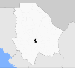
 Municipality of Dr. Belisario Domínguez in Chihuahua | |
| Coordinates: 28°9′18″N 106°28′37″W / 28.15500°N 106.47694°W | |
| Country | |
| State | Chihuahua |
| Municipal seat | San Lorenzo |
| Area | |
| • Total | 636.3 km2 (245.7 sq mi) |
| Population (2010) | |
| • Total | 2,911 |
Dr. Belisario Domínguez is one of the 67 municipalities of Chihuahua, in northern Mexico. The municipal seat lies at San Lorenzo. The municipality covers an area of 7,877 km2.
As of 2010, the municipality had a total population of 2,911, [1] up from 1,453 as of 2005. [2]
The municipality had 41 localities, none of which had a population over 1,000. [1]
It acquired its present name in 1935 in honor of Belisario Domínguez, a senator for Chiapas murdered during the Mexican Revolution.
Geography
Towns and villages
The municipality has 23 localities.
| Name | Population (2005) |
|---|---|
| Tutuaca | 752 |
| Santa María de Cuevas | 324 |
| Santa Rosalía de Cuevas | 308 |
| San Lorenzo | 308 |
| Total Municipality | 7471 |
References
- ^ a b "Dr. Belisario Domínguez". Catálogo de Localidades. Secretaría de Desarrollo Social (SEDESOL). Retrieved 23 April 2014.
- ^ "Dr. Belisario Domínguez". Enciclopedia de los Municipios de México. Instituto Nacional para el Federalismo y el Desarrollo Municipal. Archived from the original on May 28, 2007. Retrieved August 22, 2008.

