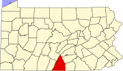
Doylesburg, Pennsylvania | |
|---|---|
Unincorporated community | |
| Coordinates: 40°12′48″N 77°42′00″W / 40.21333°N 77.70000°W | |
| Country | United States |
| State | Pennsylvania |
| County | Franklin |
| Elevation | 1,040 ft (320 m) |
| Time zone | UTC-5 ( Eastern (EST)) |
| • Summer ( DST) | UTC-4 (EDT) |
| ZIP code | 17219
[1] |
| Area code(s) | 223 & 717 |
| GNIS feature ID | 1173439 [2] |
Doylesburg is an unincorporated community in Franklin County, in the U.S. state of Pennsylvania. [2]
History
Doylesburg was platted in 1851 by Philip T. Doyle, and named for him. [3] A post office was established at Doylesburg in 1854. [4]
References
- ^ United States Postal Service. "USPS - Look Up a ZIP Code". Retrieved August 12, 2017.
- ^ a b U.S. Geological Survey Geographic Names Information System: Doylesburg, Pennsylvania
- ^ M'Cauley, I. H. (1878). Historical Sketch of Franklin County, Pennsylvania. Patriot. p. 207.
- ^ "Franklin County". Jim Forte Postal History. Retrieved June 19, 2017.

