| Cermak branch | ||||||||||||||||||||||||||||||||||||||||||||||||||||||||||||||||||||||||||||||||||||||||||||||||||||||||||||||||||||||||||||||||||||||||||||||||||||||||||||||||||||||||||||||||||||||||||||||||||||||||||||||||||||||||||||||||||||||||||||||||||||||||||||||||||||||||||||||||||||||||||||||||||||||||||||||||||||||||||||||||||||||||||||||||||||||||||||||||||||||||||||||||||||||||||||||||||||||||||
|---|---|---|---|---|---|---|---|---|---|---|---|---|---|---|---|---|---|---|---|---|---|---|---|---|---|---|---|---|---|---|---|---|---|---|---|---|---|---|---|---|---|---|---|---|---|---|---|---|---|---|---|---|---|---|---|---|---|---|---|---|---|---|---|---|---|---|---|---|---|---|---|---|---|---|---|---|---|---|---|---|---|---|---|---|---|---|---|---|---|---|---|---|---|---|---|---|---|---|---|---|---|---|---|---|---|---|---|---|---|---|---|---|---|---|---|---|---|---|---|---|---|---|---|---|---|---|---|---|---|---|---|---|---|---|---|---|---|---|---|---|---|---|---|---|---|---|---|---|---|---|---|---|---|---|---|---|---|---|---|---|---|---|---|---|---|---|---|---|---|---|---|---|---|---|---|---|---|---|---|---|---|---|---|---|---|---|---|---|---|---|---|---|---|---|---|---|---|---|---|---|---|---|---|---|---|---|---|---|---|---|---|---|---|---|---|---|---|---|---|---|---|---|---|---|---|---|---|---|---|---|---|---|---|---|---|---|---|---|---|---|---|---|---|---|---|---|---|---|---|---|---|---|---|---|---|---|---|---|---|---|---|---|---|---|---|---|---|---|---|---|---|---|---|---|---|---|---|---|---|---|---|---|---|---|---|---|---|---|---|---|---|---|---|---|---|---|---|---|---|---|---|---|---|---|---|---|---|---|---|---|---|---|---|---|---|---|---|---|---|---|---|---|---|---|---|---|---|---|---|---|---|---|---|---|---|---|---|---|---|---|---|---|---|---|---|---|---|---|---|---|---|---|---|---|---|---|---|---|---|---|---|---|---|---|---|---|---|---|---|---|---|---|---|---|---|---|---|---|---|---|---|---|---|---|---|---|---|---|---|---|---|---|---|---|
 The non-revenue junction between the Cermak and Congress branch that used to serve
Blue Line trains. | ||||||||||||||||||||||||||||||||||||||||||||||||||||||||||||||||||||||||||||||||||||||||||||||||||||||||||||||||||||||||||||||||||||||||||||||||||||||||||||||||||||||||||||||||||||||||||||||||||||||||||||||||||||||||||||||||||||||||||||||||||||||||||||||||||||||||||||||||||||||||||||||||||||||||||||||||||||||||||||||||||||||||||||||||||||||||||||||||||||||||||||||||||||||||||||||||||||||||||
| Overview | ||||||||||||||||||||||||||||||||||||||||||||||||||||||||||||||||||||||||||||||||||||||||||||||||||||||||||||||||||||||||||||||||||||||||||||||||||||||||||||||||||||||||||||||||||||||||||||||||||||||||||||||||||||||||||||||||||||||||||||||||||||||||||||||||||||||||||||||||||||||||||||||||||||||||||||||||||||||||||||||||||||||||||||||||||||||||||||||||||||||||||||||||||||||||||||||||||||||||||
| Status | Operational | |||||||||||||||||||||||||||||||||||||||||||||||||||||||||||||||||||||||||||||||||||||||||||||||||||||||||||||||||||||||||||||||||||||||||||||||||||||||||||||||||||||||||||||||||||||||||||||||||||||||||||||||||||||||||||||||||||||||||||||||||||||||||||||||||||||||||||||||||||||||||||||||||||||||||||||||||||||||||||||||||||||||||||||||||||||||||||||||||||||||||||||||||||||||||||||||||||||||||
| Locale |
Chicago,
Illinois, United States Cicero, Illinois | |||||||||||||||||||||||||||||||||||||||||||||||||||||||||||||||||||||||||||||||||||||||||||||||||||||||||||||||||||||||||||||||||||||||||||||||||||||||||||||||||||||||||||||||||||||||||||||||||||||||||||||||||||||||||||||||||||||||||||||||||||||||||||||||||||||||||||||||||||||||||||||||||||||||||||||||||||||||||||||||||||||||||||||||||||||||||||||||||||||||||||||||||||||||||||||||||||||||||
| Termini | ||||||||||||||||||||||||||||||||||||||||||||||||||||||||||||||||||||||||||||||||||||||||||||||||||||||||||||||||||||||||||||||||||||||||||||||||||||||||||||||||||||||||||||||||||||||||||||||||||||||||||||||||||||||||||||||||||||||||||||||||||||||||||||||||||||||||||||||||||||||||||||||||||||||||||||||||||||||||||||||||||||||||||||||||||||||||||||||||||||||||||||||||||||||||||||||||||||||||||
| Stations | 11 | |||||||||||||||||||||||||||||||||||||||||||||||||||||||||||||||||||||||||||||||||||||||||||||||||||||||||||||||||||||||||||||||||||||||||||||||||||||||||||||||||||||||||||||||||||||||||||||||||||||||||||||||||||||||||||||||||||||||||||||||||||||||||||||||||||||||||||||||||||||||||||||||||||||||||||||||||||||||||||||||||||||||||||||||||||||||||||||||||||||||||||||||||||||||||||||||||||||||||
| Service | ||||||||||||||||||||||||||||||||||||||||||||||||||||||||||||||||||||||||||||||||||||||||||||||||||||||||||||||||||||||||||||||||||||||||||||||||||||||||||||||||||||||||||||||||||||||||||||||||||||||||||||||||||||||||||||||||||||||||||||||||||||||||||||||||||||||||||||||||||||||||||||||||||||||||||||||||||||||||||||||||||||||||||||||||||||||||||||||||||||||||||||||||||||||||||||||||||||||||||
| Type | Rapid transit | |||||||||||||||||||||||||||||||||||||||||||||||||||||||||||||||||||||||||||||||||||||||||||||||||||||||||||||||||||||||||||||||||||||||||||||||||||||||||||||||||||||||||||||||||||||||||||||||||||||||||||||||||||||||||||||||||||||||||||||||||||||||||||||||||||||||||||||||||||||||||||||||||||||||||||||||||||||||||||||||||||||||||||||||||||||||||||||||||||||||||||||||||||||||||||||||||||||||||
| System | Chicago "L" | |||||||||||||||||||||||||||||||||||||||||||||||||||||||||||||||||||||||||||||||||||||||||||||||||||||||||||||||||||||||||||||||||||||||||||||||||||||||||||||||||||||||||||||||||||||||||||||||||||||||||||||||||||||||||||||||||||||||||||||||||||||||||||||||||||||||||||||||||||||||||||||||||||||||||||||||||||||||||||||||||||||||||||||||||||||||||||||||||||||||||||||||||||||||||||||||||||||||||
| Services | Pink | |||||||||||||||||||||||||||||||||||||||||||||||||||||||||||||||||||||||||||||||||||||||||||||||||||||||||||||||||||||||||||||||||||||||||||||||||||||||||||||||||||||||||||||||||||||||||||||||||||||||||||||||||||||||||||||||||||||||||||||||||||||||||||||||||||||||||||||||||||||||||||||||||||||||||||||||||||||||||||||||||||||||||||||||||||||||||||||||||||||||||||||||||||||||||||||||||||||||||
| Operator(s) | Chicago Transit Authority | |||||||||||||||||||||||||||||||||||||||||||||||||||||||||||||||||||||||||||||||||||||||||||||||||||||||||||||||||||||||||||||||||||||||||||||||||||||||||||||||||||||||||||||||||||||||||||||||||||||||||||||||||||||||||||||||||||||||||||||||||||||||||||||||||||||||||||||||||||||||||||||||||||||||||||||||||||||||||||||||||||||||||||||||||||||||||||||||||||||||||||||||||||||||||||||||||||||||||
| Rolling stock | 5000-series | |||||||||||||||||||||||||||||||||||||||||||||||||||||||||||||||||||||||||||||||||||||||||||||||||||||||||||||||||||||||||||||||||||||||||||||||||||||||||||||||||||||||||||||||||||||||||||||||||||||||||||||||||||||||||||||||||||||||||||||||||||||||||||||||||||||||||||||||||||||||||||||||||||||||||||||||||||||||||||||||||||||||||||||||||||||||||||||||||||||||||||||||||||||||||||||||||||||||||
| Daily ridership | 17,474 (average weekday Feb. 2013) | |||||||||||||||||||||||||||||||||||||||||||||||||||||||||||||||||||||||||||||||||||||||||||||||||||||||||||||||||||||||||||||||||||||||||||||||||||||||||||||||||||||||||||||||||||||||||||||||||||||||||||||||||||||||||||||||||||||||||||||||||||||||||||||||||||||||||||||||||||||||||||||||||||||||||||||||||||||||||||||||||||||||||||||||||||||||||||||||||||||||||||||||||||||||||||||||||||||||||
| History | ||||||||||||||||||||||||||||||||||||||||||||||||||||||||||||||||||||||||||||||||||||||||||||||||||||||||||||||||||||||||||||||||||||||||||||||||||||||||||||||||||||||||||||||||||||||||||||||||||||||||||||||||||||||||||||||||||||||||||||||||||||||||||||||||||||||||||||||||||||||||||||||||||||||||||||||||||||||||||||||||||||||||||||||||||||||||||||||||||||||||||||||||||||||||||||||||||||||||||
| Opened | April 28, 1896 | |||||||||||||||||||||||||||||||||||||||||||||||||||||||||||||||||||||||||||||||||||||||||||||||||||||||||||||||||||||||||||||||||||||||||||||||||||||||||||||||||||||||||||||||||||||||||||||||||||||||||||||||||||||||||||||||||||||||||||||||||||||||||||||||||||||||||||||||||||||||||||||||||||||||||||||||||||||||||||||||||||||||||||||||||||||||||||||||||||||||||||||||||||||||||||||||||||||||||
| Technical | ||||||||||||||||||||||||||||||||||||||||||||||||||||||||||||||||||||||||||||||||||||||||||||||||||||||||||||||||||||||||||||||||||||||||||||||||||||||||||||||||||||||||||||||||||||||||||||||||||||||||||||||||||||||||||||||||||||||||||||||||||||||||||||||||||||||||||||||||||||||||||||||||||||||||||||||||||||||||||||||||||||||||||||||||||||||||||||||||||||||||||||||||||||||||||||||||||||||||||
| Line length | 6.6 mi (10.6 km) | |||||||||||||||||||||||||||||||||||||||||||||||||||||||||||||||||||||||||||||||||||||||||||||||||||||||||||||||||||||||||||||||||||||||||||||||||||||||||||||||||||||||||||||||||||||||||||||||||||||||||||||||||||||||||||||||||||||||||||||||||||||||||||||||||||||||||||||||||||||||||||||||||||||||||||||||||||||||||||||||||||||||||||||||||||||||||||||||||||||||||||||||||||||||||||||||||||||||||
| Character | Elevated, At-Grade Level | |||||||||||||||||||||||||||||||||||||||||||||||||||||||||||||||||||||||||||||||||||||||||||||||||||||||||||||||||||||||||||||||||||||||||||||||||||||||||||||||||||||||||||||||||||||||||||||||||||||||||||||||||||||||||||||||||||||||||||||||||||||||||||||||||||||||||||||||||||||||||||||||||||||||||||||||||||||||||||||||||||||||||||||||||||||||||||||||||||||||||||||||||||||||||||||||||||||||||
| Track gauge | 4 ft 8+1⁄2 in (1,435 mm) standard gauge | |||||||||||||||||||||||||||||||||||||||||||||||||||||||||||||||||||||||||||||||||||||||||||||||||||||||||||||||||||||||||||||||||||||||||||||||||||||||||||||||||||||||||||||||||||||||||||||||||||||||||||||||||||||||||||||||||||||||||||||||||||||||||||||||||||||||||||||||||||||||||||||||||||||||||||||||||||||||||||||||||||||||||||||||||||||||||||||||||||||||||||||||||||||||||||||||||||||||||
| Electrification | Third rail, 600 V DC | |||||||||||||||||||||||||||||||||||||||||||||||||||||||||||||||||||||||||||||||||||||||||||||||||||||||||||||||||||||||||||||||||||||||||||||||||||||||||||||||||||||||||||||||||||||||||||||||||||||||||||||||||||||||||||||||||||||||||||||||||||||||||||||||||||||||||||||||||||||||||||||||||||||||||||||||||||||||||||||||||||||||||||||||||||||||||||||||||||||||||||||||||||||||||||||||||||||||||
| ||||||||||||||||||||||||||||||||||||||||||||||||||||||||||||||||||||||||||||||||||||||||||||||||||||||||||||||||||||||||||||||||||||||||||||||||||||||||||||||||||||||||||||||||||||||||||||||||||||||||||||||||||||||||||||||||||||||||||||||||||||||||||||||||||||||||||||||||||||||||||||||||||||||||||||||||||||||||||||||||||||||||||||||||||||||||||||||||||||||||||||||||||||||||||||||||||||||||||
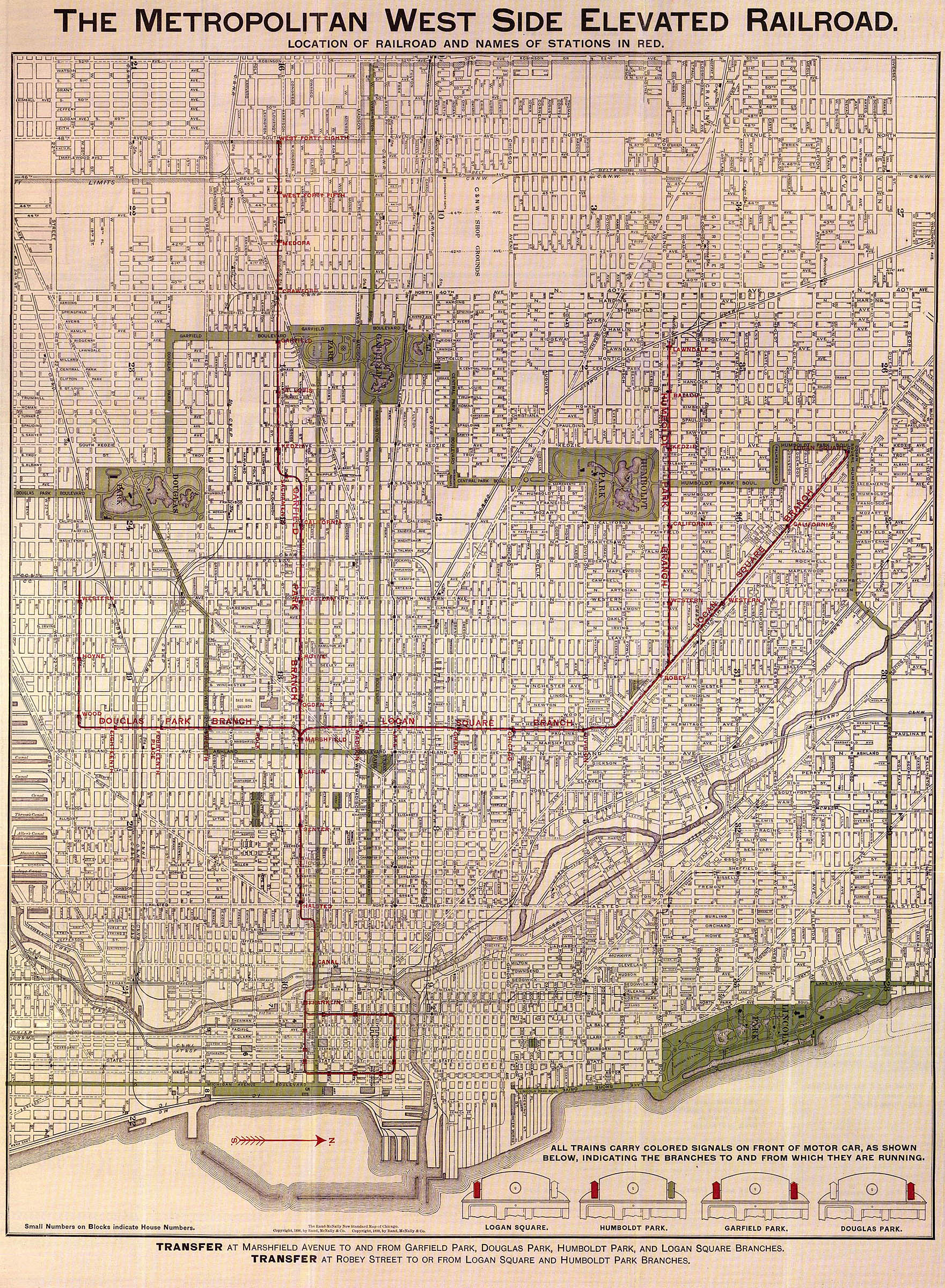
The Cermak branch, formerly known as the Douglas branch, is a 6.6 mi (10.6 km) long section of the Pink Line of the Chicago "L" system in Chicago, Illinois. It was built by the Metropolitan West Side Elevated west of the Loop. As of February 2013, it serves an average of 17,474 passengers every weekday. [1] The branch serves the Near West Side, Pilsen, Lower West Side, South Lawndale, and North Lawndale neighborhoods of Chicago, and the west suburb Cicero, Illinois. The branch operates from 4:05 a.m. to 1:25 a.m., weekdays, and Saturdays from 5:05 a.m. to 1:25 a.m., and Sundays from 5:00 a.m. to 1:25 a.m., including holidays.
History
Initially known as the Douglas Park branch, construction began in June 1893 and the line was inaugurated on April 28, 1896, between Marshfield Avenue and 18th Street. The branch started off with four stations and was the shortest of the Metropolitan West Side Elevated. Construction time was longer than in other sections. [2] On August 7, 1896, the Douglas Park branch was extended to Western. [3]
On June 29, 1900, the City of Chicago approved an extension of the branch to Pulaski (then 40th Avenue) and construction took place in mid-June 1901. On March 10, 1902, the Douglas Park branch was extended to Lawndale Avenue, which allowed the opening of four new stations: California, Kedzie, Homan, and Clifton Park (Drake).
On May 22, 1907, the Douglas Park branch was extended to 46th Avenue (Kenton Avenue), which is the Chicago city limits. The station was a few meters from the Hawthorne plant of the Western Electric which was one of the largest employers in the area of Chicago at the time. On December 16, 1907, the Douglas Park branch was extended to Cicero (then 48th Avenue), extending service to the town of Cicero, Illinois.
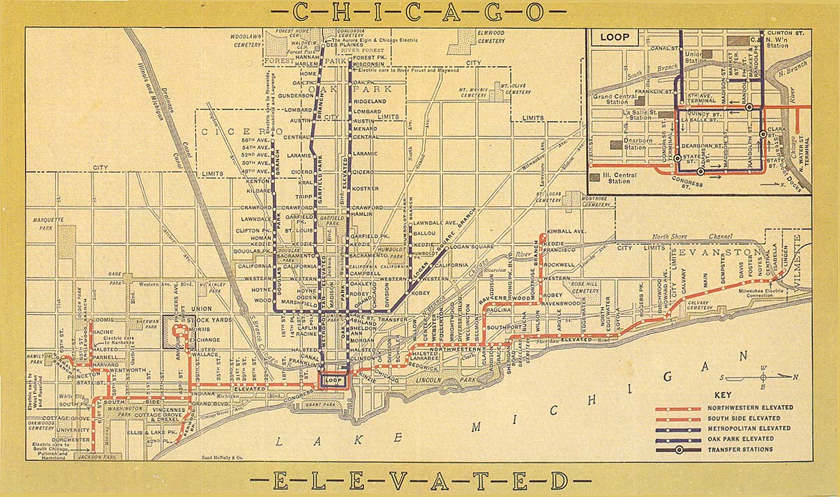
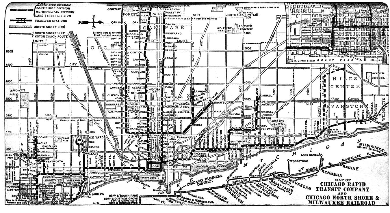
On August 20, 1910, the Douglas Park branch was extended to Laramie (then 52nd Avenue Avenue). [2] On August 1, 1912, service was extended to 56th Avenue (Central Avenue) [4] and extended again to Lombard Avenue exactly three years later. The final stretch on the branch was to Oak Park Avenue, in Berwyn, which opened on March 16, 1924. [5]
On December 9, 1951, during the establishment of skip/stop A/B, the Chicago Transit Authority l, which had taken over operation of the "L" system in 1947, streamlined service on the line and shut down five stations: 14th Place, Homan, Drake, Lawndale and Kenton, while opening a station at Central Park. On February 3, 1952, service on the Douglas line was suspended to all stations west of 54th/Cermak. Service to these areas was replaced by a bus route. [6]
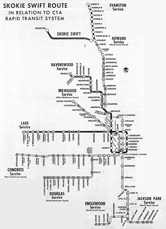
The stations at Roosevelt and Douglas Park were closed three months later. [2] On June 22, 1958, Douglas trains were rerouted to the West-Northwest route, the Congress branch, the new line in the middle of the Eisenhower Expressway and connecting routes to the Milwaukee-Dearborn Subway, heading north to Logan Square. [7] The new system changed the service and it was decided that all stations on the Douglas branch would now be "B" and the Congress branch would now be "A". In 1973, due to budget cuts, the 50th Avenue station closed. [2]
Renovations
In 1983, Polk and Cicero were rebuilt to make them ADA accessible for passengers with disabilities. The poorly utilized Laramie station was closed to accelerate service the following year. In 1993, 18th was rebuilt to provide access for passengers with disabilities and the CTA color-coded the lines, placing the Douglas branch as part of the Blue Line. In 1995, the A/B service was abandoned and all trains stop at every station, which does not affect the service of the stations on the Douglas branch. In 1996, the CTA changed the name of the branch to the Cermak branch, although Chicagoans still use the name "Douglas" to refer to the line. In 1998, the branch lost its 24-hour service, along with the Purple and Green lines. On September 10, 2001, the CTA began a $363 million renovation project of the branch which was completed on January 8, 2005. [8] As of today, all eleven stations on the branch are ADA accessible.
Current
The current Pink Line route was assigned to the Douglas branch on June 25, 2006. [9] The CTA ended Blue Line service on the Douglas branch on April 25, 2008. [2]
Station listing
| Station | Location | Notes |
|---|---|---|
| Oak Park | Oak Park Avenue and 22nd Street | Closed February 3, 1952 |
| Ridgeland | Ridgeland Avenue and 21st Street | Closed February 3, 1952 |
| Lombard | Lombard Avenue and 21st Street | Closed February 3, 1952 |
| Austin | Austin Boulevard and 21st Street | Closed February 3, 1952 |
| 58th Avenue | 58th Avenue and 21st Street | Closed February 3, 1952 |
| Central | Central Avenue and Cermak Road | Closed February 3, 1952
Originally known as 56th Avenue |
|
54th/Cermak
|
2151 S. 54th Avenue, Cicero, Illinois | Auxiliary entrance at Laramie Avenue |
| Laramie | 2130 S. Laramie Avenue, Cicero, Illinois | Closed February 9, 1992; reopened in December 2001 during Douglas branch renovation and closed on August 16, 2003
Originally known as 52nd Avenue |
| 50th Avenue | 2133 S. 50th Avenue, Cicero, Illinois | Closed 1978; deconstructed, reassembled, and preserved in Illinois Railway Museum |
|
Cicero
|
2134 S. Cicero Avenue, Cicero, Illinois | Originally known as 48th Avenue |
| Kenton | Cermak Road west of Kilbourn Avenue | Closed December 9, 1951 |
|
Kostner
|
2019 S. Kostner Avenue | Originally known as Kildare (one block east of Kostner) until 2002; became Kostner July 17, 2003 and Kildare was converted into an auxiliary entrance |
|
Pulaski
|
2021 S. Pulaski Road | Originally known as 40th Avenue Terminal and later Crawford Avenue. |
| Lawndale | Lawndale Avenue and 21st Street | Closed December 9, 1951 |
|
Central Park
|
1944 S. Central Park Avenue | South Lawndale, Little Village |
| Drake | Drake Avenue and 21st Street | Closed December 9, 1951 |
| Homan | Homan Avenue and 21st Street | Closed December 9, 1951 |
|
Kedzie
|
1944 S. Kedzie Avenue | |
| Douglas Park | 2008 S. Marshall Boulevard | Closed May 3, 1952 |
|
California
|
2010 S. California Avenue | |
|
Western
|
2010 S. Western Avenue | |
|
Damen
|
2010 S. Damen Avenue | Originally known as Hoyne (one block west of Damen) until 2002; became Damen on July 22, 2004 and Hoyne was converted into an auxiliary entrance |
| Wood | Wood Street and 21st Street | Closed May 19, 1957 |
|
18th
|
1710 W. 18th Street | |
| 14th Place | 14th Place and Paulina Street | Closed December 9, 1951 |
| Roosevelt | Roosevelt Road and Paulina Street | Closed May 3, 1952
Originally known as 12th Street |
|
Polk
|
1713 W. Polk Street |
Image gallery
-
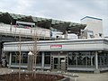
 An art wall sitting just outside the entrance at Western
 -
 The 18th station is built with art walls and structures
 -
 The Kedzie station has a wide-wooden platform with passenger shelters
 -
 The side entrance and small plaza at Central Park.


References
- ^ "Ridership Report: February 2013" (PDF). Chicago Transit Authority. Archived from the original (PDF) on February 4, 2018. Retrieved April 8, 2013.
- ^ a b c d e "Cermak (Douglas) branch". Chicago"L".org. Retrieved August 18, 2013.
- ^ The Metropolitan West Side Elevated Railroad (Map). Metropolitan West Side Elevated Railroad. 1898. Retrieved August 18, 2013.
- ^ Chicago Elevated Railroads (Map). Chicago Elevated Railways. 1913. Retrieved August 18, 2013.
- ^ Know Chicago - Shealy's New Idea Street Guide for Quick Service (Map). J.P. Shealy Street Guide. 1925. Retrieved August 18, 2013.
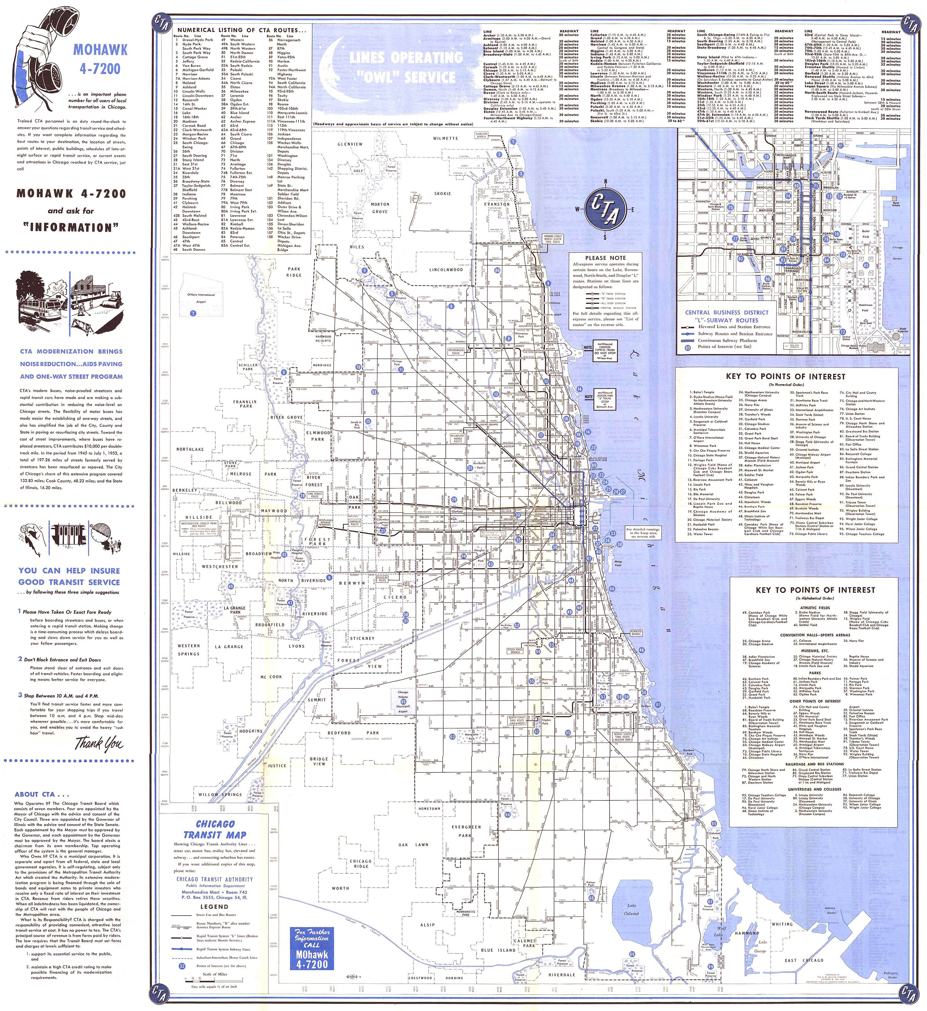
- ^ Chicago Transit Map (Map). Chicago Transit Authority. 1954. Retrieved August 18, 2013.
- ^ Skokie Swift: "The Commuter's Friend" (Map). Chicago Transit Authority. 1965. Retrieved August 18, 2013.
- ^ "Douglas branch renovation". Kiewit Corporation. Archived from the original on October 6, 2013. Retrieved February 9, 2013.
- ^ Groark, Virginia. "CTA Pink Line is ready for service". Chicago Tribune. Retrieved February 9, 2013.