Dorothy Scott Airport Dorothy Scott Municipal Airport Dorothy Scott International Airport | |||||||||||
|---|---|---|---|---|---|---|---|---|---|---|---|
| Summary | |||||||||||
| Airport type | Public | ||||||||||
| Owner/Operator | City of Oroville | ||||||||||
| Location | Oroville, Washington | ||||||||||
| Coordinates | 48°57′42″N 119°24′41″W / 48.96167°N 119.41139°W | ||||||||||
| Map | |||||||||||
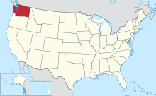
 The state of which Dorothy Scott is located in, Washington. | |||||||||||
| Runways | |||||||||||
| |||||||||||
| Statistics (2012) | |||||||||||
| |||||||||||
Source:
Federal Aviation Administration
[1] | |||||||||||
Dorothy Scott Airport ( FAA LID: 0S7) is a public international airport in Oroville, Washington, United States—a city in the Okanogan region [2]—that was opened in August 1937. [3] It is located 2 miles northeast from the town center, being owned by the City of Oroville. [4] Dorothy Scott Airport has been approved for use. [4] The airport has a pavement management plan to repair the airport's one runway. [5] [6]
History
Dorothy Scott Airport is one of two airports named after a woman who served in World War II for the Women Airforce Service Pilots (WASP) department. [7] Dorothy Scott died during World War II while ferrying aircraft to England and received a posthumous Congressional Gold Medal in 2010. [7] It is classified as an airport of entry by the Washington state, [7] and operates an airport layout plan. [8]
Facilities and aircraft
The airport holds a service classification of federal general aviation airport. [7] In 2010, 40 planes left the airport for local military services, while the same number of planes left it as commercial air taxis. [7] 12,000 airplanes left Dorothy Scott for general itinerant use, and 3100 left as general local flights. [7]
The nearest radio navigation aids from the airport that help the pilot are located in three cities: Omak, Penticton, and Naramata. [3] The last two locations are in Canada. [3] Steven Johnson serves as the airports service manager. [1] The airport offers a public taxi transportation service. [9] The airplane's Area Control Center is located in Seattle, Washington. [10]
Growth
Johnston claimed that the amount of activity at the Dorothy Scott Airport is "amazing". [11] He felt that throughout August and September 2012, the airport has gotten busier. [11] According to Johnston, a person purchased a US$4000 hangar to be placed at this airport. [11] Big World of Flight—an organization that educates children on aviation—is one company that Johnston noted will stop at the airport in September 2012. [11] He assured that Oroville's priority is the expanding of the airport. [11]
See also
References
- ^ a b "FAA Airport Master Record for 0S7". Federal Aviation Administration. November 18, 2012. Retrieved November 18, 2012.
- ^ "Dorothy Scott Municipal". Washington. Retrieved November 17, 2012.
- ^ a b "Airport Identification Information". Washington. Archived from the original on November 16, 2012. Retrieved November 17, 2012.
- ^ "Dorothy Scott Airport 2005 Pavement Management Report" (PDF). Washington. Retrieved November 17, 2012.
- ^ "Dorothy Scott Airport 2001 Airport Economic Profile" (PDF). Washington. Retrieved November 17, 2012.
- ^ a b c d e f "Dorothy Scott Municipal" (PDF). Washington. Retrieved November 17, 2012.
- ^ "Airport layout plan" (PDF). Washington. Retrieved November 17, 2012.
- ^ "Dorothy Scott Airport" (PDF). Washington. Retrieved November 17, 2012.
- ^ "Dorothy Scott Airport". SkyVector. Retrieved November 18, 2012.
- ^ a b c d e DeVon, Gary (September 27, 2012). "Oroville's Dorothy Scott Airport abuzz with activity". Okanogan Valley Gazette–Tribune. Retrieved November 17, 2012.