Dora, Alabama | |
|---|---|
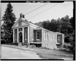 Old Methodist Church, taken as part of the
Historic American Buildings Survey | |
 Location of Dora in Walker County, Alabama. | |
| Coordinates: 33°43′45″N 87°5′25″W / 33.72917°N 87.09028°W | |
| Country | United States |
| State | Alabama |
| County | Walker |
| Government | |
| • Mayor | Randy Stephens |
| Area | |
| • Total | 7.92 sq mi (20.51 km2) |
| • Land | 7.91 sq mi (20.49 km2) |
| • Water | 0.01 sq mi (0.03 km2) |
| Elevation | 394 ft (120 m) |
| Population (
2020) | |
| • Total | 2,297 |
| • Density | 290.43/sq mi (112.13/km2) |
| Time zone | UTC-6 ( Central (CST)) |
| • Summer ( DST) | UTC-5 (CDT) |
| ZIP code | 35062
[2] |
| Area code(s) | 205 and 659 |
| FIPS code | 01-21136 |
| GNIS feature ID | 0155055 |
| Website | www.cityofdora.com |
Dora is a city in Walker County, Alabama, United States. Coal mining took place in the area.
History
The first settlers in the area now known as Dora were James. M. Davis, Ezekiel Morgan, and Cole Smith [3] in the early 1830s. [4] [5] Later in the 1830s, homesteaders settled here. The Kansas City, Memphis and Birmingham Railroad laid a line through the settlement in 1886, and called their depot "Sharon". [4] The Magella Coal Company and the Horse Creek Coal and Coke Company were founded, and by 1890, the area was called Horse Creek and incorporated as the town of Horse Creek in 1897. [4] By 1900, several coal mines were located nearby. There was a school, churches, businesses and doctors. The name was changed to Dora in 1906. [5] At the 2020 census the population was 2,297, up from 2,024 in 2010.
Geography
According to the U.S. Census Bureau, the city has a total area of 7.5 square miles (19 km2), all land.
Demographics
| Census | Pop. | Note | %± |
|---|---|---|---|
| 1900 | 385 | — | |
| 1910 | 916 | 137.9% | |
| 1920 | 1,117 | 21.9% | |
| 1930 | 1,143 | 2.3% | |
| 1940 | 1,032 | −9.7% | |
| 1950 | 984 | −4.7% | |
| 1960 | 1,776 | 80.5% | |
| 1970 | 1,862 | 4.8% | |
| 1980 | 2,327 | 25.0% | |
| 1990 | 2,214 | −4.9% | |
| 2000 | 2,413 | 9.0% | |
| 2010 | 2,025 | −16.1% | |
| 2020 | 2,297 | 13.4% | |
| U.S. Decennial Census
[6] 2013 Estimate [7] | |||
2000 census
At the 2000 census there were 2,413 people, 984 households, and 711 families living in the city. The population density was 319.9 inhabitants per square mile (123.5/km2). There were 1,080 housing units at an average density of 143.2 per square mile (55.3/km2). The racial makeup of the city was 80.61% White, 16.66% Black or African American, 0.29% Native American, 0.21% Asian, 0.08% Pacific Islander, 0.08% from other races, and 2.07% from two or more races. 0.12% of the population were Hispanic or Latino of any race. [8] Of the 984 households 32.9% had children under the age of 18 living with them, 50.3% were married couples living together, 18.8% had a female householder with no husband present, and 27.7% were non-families. 25.3% of households were one person and 11.8% were one person aged 65 or older. The average household size was 2.45 and the average family size was 2.93.
The age distribution was 26.2% under the age of 18, 8.8% from 18 to 24, 26.5% from 25 to 44, 25.1% from 45 to 64, and 13.5% 65 or older. The median age was 36 years. For every 100 females, there were 81.8 males. For every 100 females age 18 and over, there were 80.3 males.
The median household income was $21,458 and the median family income was $29,000. Males had a median income of $28,942 versus $19,886 for females. The per capita income for the city was $14,560. About 23.1% of families and 27.9% of the population were below the poverty line, including 39.0% of those under age 18 and 23.5% of those age 65 or over.
2010 census
At the 2010 census there were 2,025 people, 820 households, and 575 families living in the city. The population density was 270 inhabitants per square mile (100/km2). There were 959 housing units at an average density of 127.9 per square mile (49.4/km2). The racial makeup of the city was 85.6% White, 12.2% Black or African American, 0.3% Native American, 0% Asian, 0.1% Pacific Islander, 0.3% from other races, and 1.3% from two or more races. 0.7% of the population were Hispanic or Latino of any race. [9] Of the 820 households 27.0% had children under the age of 18 living with them, 48.8% were married couples living together, 17.1% had a female householder with no husband present, and 29.9% were non-families. 27.2% of households were one person and 11.3% were one person aged 65 or older. The average household size was 2.47 and the average family size was 2.98.
The age distribution was 23.6% under the age of 18, 8.4% from 18 to 24, 26.3% from 25 to 44, 25.5% from 45 to 64, and 16.2% 65 or older. The median age was 39.2 years. For every 100 females, there were 91.4 males. For every 100 females age 18 and over, there were 97.6 males.
The median household income was $26,596 and the median family income was $37,946. Males had a median income of $35,586 versus $22,652 for females. The per capita income for the city was $18,902. About 29.0% of families and 25.0% of the population were below the poverty line, including 42.3% of those under age 18 and 3.1% of those age 65 or over.
The city is home to Dora High School with students from Elementary and Middle Schools in Sumiton. [10] The mascot for the high school is the bulldog and it is a member of the Walker County Board of Education.
2020 census
| Race | Num. | Perc. |
|---|---|---|
| White (non-Hispanic) | 1,817 | 79.1% |
| Black or African American (non-Hispanic) | 326 | 14.19% |
| Native American | 6 | 0.26% |
| Asian | 24 | 1.04% |
| Other/Mixed | 108 | 4.7% |
| Hispanic or Latino | 16 | 0.7% |
As of the 2020 United States census, there were 2,297 people, 901 households, and 596 families residing in the city.
Administration
Mayor: Randy Stephens
Council meetings are held the 2nd and 4th Thursday of each month at 6pm. The public is encouraged to attend.
Schools
Dora High School (330 Glenn C Gant Cir, Dora, AL 35062)
Parks
Dora has one city park located behind city hall (1485 Sharon Blvd, Dora AL, 35062)
Police Department
Located under City Hall (1485 Sharon Blvd, Dora AL, 35062)
Fire Department
Located Behind City Hall (1485 Sharon Blvd, Dora AL, 35062)
Notable people
- Ivy Andrews, former Major League Baseball pitcher
- Terry Fell, country music singer
- Sybil Gibson, painter
- Howard Goodman (gospel singer), gospel music
- Chavis Williams, former linebacker for the Baltimore Ravens
- Jimi Westbrook, Musician in the band Little Big Town
See also
References
- ^ "2020 U.S. Gazetteer Files". United States Census Bureau. Retrieved October 29, 2021.
- ^ "Dora AL ZIP Code". zipdatamaps.com. 2023. Retrieved January 26, 2023.
- ^ http://encyclopediaofalabama.org/article/h-3604
- ^ a b c Dora, City of (1986). Dora Centennial 1886 to 1986 Scrapbook of Memories. Dora, Alabama: The Davis Printing Place.
- ^ a b "Encyclopedia of Alabama". Alabama Humanities Foundation. Archived from the original on January 10, 2015. Retrieved September 1, 2014.
- ^ "U.S. Decennial Census". Census.gov. Retrieved June 6, 2013.
- ^ "Annual Estimates of the Resident Population: April 1, 2010 to July 1, 2013". Archived from the original on May 22, 2014. Retrieved June 3, 2014.
- ^ "U.S. Census website". United States Census Bureau. Retrieved January 31, 2008.
- ^ "U.S. Census website". United States Census Bureau. Retrieved August 14, 2015.
- ^ "Walker County Board of Education". Walker County Alabama Board of Education.
- ^ "Explore Census Data". data.census.gov. Retrieved December 11, 2021.
External links
- HAER No. AL-99, " Dora Community, County Road 81, Dora, Walker County, AL", 1 photo, 5 data pages, 1 photo caption page
Municipalities and communities of
Walker County, Alabama, United States | ||
|---|---|---|
| Cities | 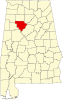 | |
| Towns | ||
|
Unincorporated communities | ||
| Footnotes | ‡This populated place also has portions in an adjacent county or counties | |
| International | |
|---|---|
| National | |
| Geographic | |
| Other | |