| Donoho Peak | |
|---|---|
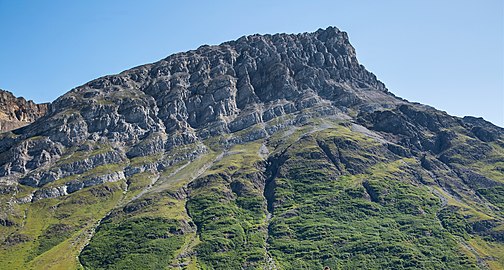
 Donoho Peak, south aspect | |
| Highest point | |
| Elevation | 6,696 ft (2,041 m) [1] |
| Prominence | 1,496 ft (456 m) [1] |
| Parent peak | Bonanza Peak |
| Isolation | 3.68 mi (5.92 km) [2] |
| Coordinates | 61°33′25″N 142°58′20″W / 61.557068°N 142.9723372°W [3] |
| Geography | |
 Donoho Peak Location of Donoho Peak in Alaska | |
| Location |
Wrangell-St. Elias National Park Valdez-Cordova Borough Alaska, United States |
| Parent range | Wrangell Mountains |
| Topo map | USGS McCarthy C-6 |
| Geology | |
| Age of rock | Cretaceous |
| Type of rock | Greenstone, Limestone |
| Climbing | |
| Easiest route | Scrambling, Glacier crossing |
Donoho Peak is a 6,696-foot-elevation (2,041 meter) mountain summit located in the Wrangell Mountains, in the U.S. state of Alaska. The peak is situated in Wrangell-St. Elias National Park and Preserve, 6 mi (10 km) north-northwest of Kennecott, and 9 mi (14 km) north of McCarthy, at the confluence of the Kennicott Glacier and Root Glacier. The peak's name was reported in 1931 by the United States Geological Survey. [3] The mountain lies within the Copper River drainage basin. Bears frequent the Donoho Peak and Donoho Lakes area. An ascent of the mountain involves 14 miles round-trip from Kennecott to the summit, including crossing the Root Glacier and gully scramble via the south aspect of the mountain. Ruins of the Regal Mine remain at an elevation of 5,440 feet on the south slope of the mountain. Only small amounts of copper ore were ever produced, however. On a clear day the summit of Donoho Peak offers views of Mount Blackburn to the northwest and the Stairway Icefall on Regal Mountain to the north-northeast.
Climate
Based on the Köppen climate classification, Donoho Peak is located in a subarctic climate zone with long, cold, snowy winters, and cool summers. [4] Weather systems coming off the Gulf of Alaska are forced upwards by the Wrangell Mountains ( orographic lift), causing heavy precipitation in the form of rainfall and snowfall. Temperatures can drop below −20 °C with wind chill factors below −30 °C. The months May through June offer the most favorable weather for viewing and climbing.
Geology
Donoho Peak and the ridge extending to the north separate Gates and Root Glaciers. The north-dipping section exposes most of the definitive Triassic and Jurassic units of the Wrangellia Terrane, overlain unconformably at the north end of the ridge by the Miocene Frederika Formation and the Miocene to Holocene Wrangell Lava. The peak is underlain by a conspicuous overturned syncline, which is cored by Nizina limestone, and forms a gray-colored zigzag on the east face of the peak. [5]
See also
Gallery
-
 Donoho's west side shows limestone overlying darker greenstone
 -
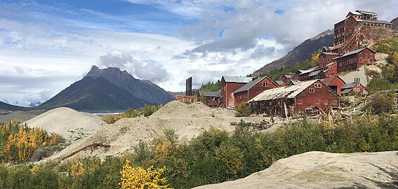 Donoho Peak (left) with historic Kennecott Mill site
 -
 Mt. Blackburn, Donoho Peak, and Kennecott Mill town.
 -
 Donoho Peak's east aspect above Root Glacier
 -
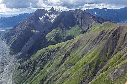 Aerial view of north aspect
 -
 Donoho Peak centered
 -
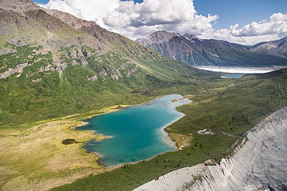 Donoho Lakes in Donoho Basin


_(21587612106).jpg)
.jpg)


References
- ^ a b "Donoho Peak, Alaska". Peakbagger.com. Retrieved 2020-02-12.
- ^ Donoho Peak, listsofjohn.com
- ^ a b "Donoho Peak". Geographic Names Information System. United States Geological Survey, United States Department of the Interior. Retrieved 2020-02-12.
- ^ Peel, M. C.; Finlayson, B. L.; McMahon, T. A. (2007). "Updated world map of the Köppen−Geiger climate classification" (PDF). Hydrol. Earth Syst. Sci. 11 (5): 1633. Bibcode: 2007HESS...11.1633P. doi: 10.5194/hess-11-1633-2007. ISSN 1027-5606. S2CID 9654551.
-
^
"Archived copy" (PDF). Archived from
the original (PDF) on 2017-02-20. Retrieved 2020-02-22.
{{
cite web}}
: CS1 maint: archived copy as title ( link)
External links
- Weather forecast: Donoho Peak
- 2021 fatality: Anchorage Daily News