Dipaculao | |
|---|---|
| Municipality of Dipaculao | |
 Panoramic | |
 Flag | |
 Map of Aurora with Dipaculao highlighted | |
.svg) Dipaculao Location within the
Philippines | |
| Coordinates: 15°59′N 121°38′E / 15.98°N 121.63°E | |
| Country | Philippines |
| Region | Central Luzon |
| Province | Aurora |
| District | Lone district |
| Founded | November 27, 1950 |
| Barangays | 25 (see Barangays) |
| Government | |
| • Type | Sangguniang Bayan |
| • Mayor | Danilo A. Tolentino |
| • Vice Mayor | Franklin J. Reyes |
| • Representative | Rommel Rico T. Angara |
| • Municipal Council | Members |
| • Electorate | 21,125 voters ( 2022) |
| Area | |
| • Total | 361.64 km2 (139.63 sq mi) |
| Elevation | 45 m (148 ft) |
| Highest elevation | 622 m (2,041 ft) |
| Lowest elevation | 0 m (0 ft) |
| Population (2020 census)
[3] | |
| • Total | 33,131 |
| • Density | 92/km2 (240/sq mi) |
| • Households | 8,183 |
| Economy | |
| • Income class | 3rd municipal income class |
| • Poverty incidence | 11.35 |
| • Revenue | ₱ 173.7 million (2020) |
| • Assets | ₱ 323 million (2020) |
| • Expenditure | ₱ 157.3 million (2020) |
| • Liabilities | ₱ 40.34 million (2020) |
| Service provider | |
| • Electricity | Aurora Electric Cooperative (AURELCO) |
| Time zone | UTC+8 ( PST) |
| ZIP code | 3203 |
| PSGC | |
| IDD : area code | +63 (0)42 |
| Native languages | Ilocano Tagalog |
| Website |
www |
Dipaculao [ˌdiːpɐˈkuːlaʊ], officially the Municipality of Dipaculao ( Tagalog: Bayan ng Dipaculao; Ilocano: Ili ti Dipaculao), is a 3rd class municipality in the province of Aurora, Philippines. According to the 2020 census, it has a population of 33,131 people. [3]
The municipality is home to the Dinadiawan River Protected Landscape.
History
In the early part of 1921, immigrants from Central Luzon, including Ilocanos, arrived at present-day municipality, which was then a large strip of virgin lands along the Pacific Coast in what was then part of the province of Nueva Vizcaya; Central Luzon just did not include the literal political region, it also encompasses the central geographic location of Luzon island, it also includes Nueva Ecija, Tarlac, present areas of Nueva Vizcaya, and Pangasinan, which was politically part of Central Luzon itself. Another group of Ilocano settlers arrived from Ilocos Region, including La Union and Pangasinan. Igorots from present Mountain Province arrived and settled the town, and lived along with Ilocanos and Ilongots.
Dipaculao was accidentally created while the Ilongots, the first inhabitants, were having thanksgiving festivities to commemorate the abundance of hunting and harvesting. Dipac [ˈdiːpak], the Ilongot chieftain, was drunk with basi and tuba. The Ilocanos who were present saw him fell and shouted: "Dipac naulaw" or "Naulaw ni Dipac" (Dipac got dizzy, idiomatically "Dipac is/got drunk"), hence born the name Dipaculao.
On November 27, 1950, Dipaculao was converted from a barrio of Baler into an independent municipality of Quezon thru Executive Order No. 375. [5] The late Anacleto Mijares was the first Municipal Mayor administered the transition of the municipality. [6]
On June 21, 1957, the sitios of Dimabuno, Laboy, Dinadiawan and Puangi were converted into barrios. [7] [8] [9] [10] Several more sitios were converted into barrios on June 18, 1966. [11]
Geography
According to the Philippine Statistics Authority, the municipality has a land area of 361.64 square kilometres (139.63 sq mi) [12] constituting 11.49% of the 3,147.32-square-kilometre- (1,215.19 sq mi) total area of Aurora.
Dipaculao is 11 kilometres (6.8 mi) from Baler and 242 kilometres (150 mi) from Manila.
Barangays
Dipaculao is politically subdivided into 25 barangays. [13] Each barangay consists of puroks and some have sitios.
| PSGC | Barangay | Population | ±% p.a. | |||
|---|---|---|---|---|---|---|
| 2020 [3] | 2010 [14] | |||||
| 037706001 | Bayabas | 2.8% | 915 | 914 | 0.01% | |
| 037706003 | Borlongan | 7.3% | 2,416 | 2,173 | 1.07% | |
| 037706002 | Buenavista | 1.7% | 569 | 554 | 0.27% | |
| 037706004 | Calaocan | 2.5% | 816 | 873 | −0.67% | |
| 037706025 | Diamanen | 1.0% | 331 | 172 | 6.76% | |
| 037706005 | Dianed | 2.2% | 722 | 588 | 2.07% | |
| 037706006 | Diarabasin | 5.2% | 1,730 | 1,621 | 0.65% | |
| 037706007 | Dibutunan | 2.6% | 860 | 723 | 1.75% | |
| 037706008 | Dimabuno | 3.6% | 1,195 | 1,023 | 1.57% | |
| 037706009 | Dinadiawan | 11.3% | 3,733 | 3,670 | 0.17% | |
| 037706010 | Ditale | 4.2% | 1,398 | 1,297 | 0.75% | |
| 037706011 | Gupa | 3.1% | 1,037 | 991 | 0.45% | |
| 037706012 | Ipil | 3.5% | 1,154 | 1,149 | 0.04% | |
| 037706013 | Laboy | 1.4% | 454 | 404 | 1.17% | |
| 037706014 | Lipit | 2.9% | 968 | 818 | 1.70% | |
| 037706015 | Lobbot | 1.8% | 580 | 475 | 2.02% | |
| 037706016 | Maligaya | 2.0% | 665 | 574 | 1.48% | |
| 037706017 | Mijares | 3.4% | 1,134 | 1,014 | 1.12% | |
| 037706018 | Mucdol | 4.5% | 1,479 | 1,476 | 0.02% | |
| 037706019 | North Poblacion | 6.2% | 2,059 | 2,058 | 0.00% | |
| 037706020 | Puangi | 4.3% | 1,430 | 1,314 | 0.85% | |
| 037706021 | Salay | 4.3% | 1,417 | 1,323 | 0.69% | |
| 037706022 | Sapangkawayan | 1.2% | 405 | 349 | 1.50% | |
| 037706023 | South Poblacion | 5.1% | 1,693 | 1,688 | 0.03% | |
| 037706024 | Toytoyan | 1.7% | 576 | 488 | 1.67% | |
| Total | 33,131 | 27,729 | 1.80% | |||
Climate
| Climate data for Dipaculao, Aurora | |||||||||||||
|---|---|---|---|---|---|---|---|---|---|---|---|---|---|
| Month | Jan | Feb | Mar | Apr | May | Jun | Jul | Aug | Sep | Oct | Nov | Dec | Year |
| Mean daily maximum °C (°F) | 27 (81) |
28 (82) |
29 (84) |
31 (88) |
31 (88) |
31 (88) |
30 (86) |
30 (86) |
30 (86) |
30 (86) |
29 (84) |
27 (81) |
29 (85) |
| Mean daily minimum °C (°F) | 21 (70) |
21 (70) |
22 (72) |
24 (75) |
25 (77) |
25 (77) |
25 (77) |
25 (77) |
25 (77) |
24 (75) |
23 (73) |
22 (72) |
24 (74) |
| Average precipitation mm (inches) | 41 (1.6) |
39 (1.5) |
35 (1.4) |
54 (2.1) |
198 (7.8) |
246 (9.7) |
305 (12.0) |
300 (11.8) |
274 (10.8) |
192 (7.6) |
77 (3.0) |
69 (2.7) |
1,830 (72) |
| Average rainy days | 13.0 | 11.1 | 11.2 | 12.5 | 21.7 | 24.8 | 27.4 | 28.0 | 26.0 | 20.6 | 13.6 | 14.7 | 224.6 |
| Source: Meteoblue (modeled/calculated data, not measured locally) [15] | |||||||||||||
Demographics
| Year | Pop. | ±% p.a. |
|---|---|---|
| 1960 | 5,149 | — |
| 1970 | 10,228 | +7.10% |
| 1975 | 12,702 | +4.44% |
| 1980 | 15,561 | +4.14% |
| 1990 | 18,951 | +1.99% |
| 1995 | 21,044 | +1.98% |
| 2000 | 23,064 | +1.98% |
| 2007 | 24,882 | +1.05% |
| 2010 | 27,729 | +4.02% |
| 2015 | 29,736 | +1.34% |
| 2020 | 33,131 | +2.15% |
| Source: Philippine Statistics Authority [16] [14] [17] [18] | ||
In the 2020 census, Dipaculao had a population of 33,131. [3] The population density was 92 inhabitants per square kilometre (240/sq mi).
Economy
Graphs are unavailable due to technical issues. There is more info on
Phabricator and on
MediaWiki.org. |
Gallery
-
 South Poblacion
 -
 Dinadiawan white beach (a long stretch of clean, fine, golden white sand coastline)
 -
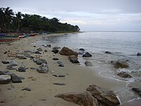 Rock formations along the shoreline (north of Baler along the Dicadi highway)
 -
 Ampere Beach and Ampere Rock in Dipaculao


References
- ^ Municipality of Dipaculao | (DILG)
- ^ "2015 Census of Population, Report No. 3 – Population, Land Area, and Population Density" (PDF). Philippine Statistics Authority. Quezon City, Philippines. August 2016. ISSN 0117-1453. Archived (PDF) from the original on May 25, 2021. Retrieved July 16, 2021.
- ^ a b c d Census of Population (2020). "Region III (Central Luzon)". Total Population by Province, City, Municipality and Barangay. Philippine Statistics Authority. Retrieved 8 July 2021.
- ^ "PSA Releases the 2018 Municipal and City Level Poverty Estimates". Philippine Statistics Authority. 15 December 2021. Retrieved 22 January 2022.
- ^ Executive Order No. 375, s. 1950 (27 November 1950), Organizing a portion of the municipality of Baler, province of Quezon, into an independent municipality under the name of Dipaculao, retrieved August 11, 2022
-
^
"History". Local Government of Dipaculao. Retrieved August 11, 2022.
 This article incorporates text from this source, which is in the
public domain.
This article incorporates text from this source, which is in the
public domain.
- ^ Republic Act No. 1761 (21 June 1957), "An Act Creating the Barrio of Laboy in the Municipality of Dipaculao, Province of Quezon", PhilippineLaw.info, archived from the original on 15 May 2012, retrieved 6 November 2016
- ^ Republic Act No. 1762 (21 June 1957), "RAn Act Creating the Barrio of Dinadiawan in the Municipality of Dipaculao, Province of Quezon", PhilippineLaw.info, archived from the original on 15 May 2012, retrieved 6 November 2016
- ^ Republic Act No. 1763 (21 June 1957), "An Act Creating the Barrio of Puangi in the Municipality of Dipaculao, Province of Quezon", PhilippineLaw.info, archived from the original on 15 May 2012, retrieved 6 November 2016
- ^ Republic Act No. 1764 (21 June 1957), "An Act Creating the Barrio of Dimabono in the Municipality of Dipaculao, Province of Quezon", PhilippineLaw.info, archived from the original on 15 May 2012, retrieved 6 November 2016
- ^ Republic Act No. 4809 (18 June 1966), "An Act Creating Certain Barrios in the Municipalities of Dipaculao and San Luis and the Municipal District of Dilasag, Province of Quezon", Chan Robles Virtual Law Library, archived from the original on 25 September 2013, retrieved 6 November 2016
- ^ "Province: Aurora". PSGC Interactive. Quezon City, Philippines: Philippine Statistics Authority. Retrieved 12 November 2016.
- ^ "Municipal: Dipaculao". PSGC Interactive. Quezon City, Philippines: Philippine Statistics Authority. Retrieved 8 January 2016.
- ^ a b Census of Population and Housing (2010). "Region III (Central Luzon)" (PDF). Total Population by Province, City, Municipality and Barangay. National Statistics Office. Retrieved 29 June 2016.
- ^ "Dipaculao, Aurora: Average Temperatures and Rainfall". Meteoblue. Retrieved 27 December 2018.
- ^ Census of Population (2015). "Region III (Central Luzon)". Total Population by Province, City, Municipality and Barangay. Philippine Statistics Authority. Retrieved 20 June 2016.
-
^ Censuses of Population (1903–2007).
"Region III (Central Luzon)".
Table 1. Population Enumerated in Various Censuses by Province/Highly Urbanized City: 1903 to 2007.
National Statistics Office.
{{
cite encyclopedia}}
: CS1 maint: numeric names: authors list ( link) - ^ "Province of Aurora". Municipality Population Data. Local Water Utilities Administration Research Division. Retrieved 17 December 2016.
- ^ "Poverty incidence (PI):". Philippine Statistics Authority. Retrieved December 28, 2020.
- ^ "Estimation of Local Poverty in the Philippines" (PDF). Philippine Statistics Authority. 29 November 2005.
- ^ "2003 City and Municipal Level Poverty Estimates" (PDF). Philippine Statistics Authority. 23 March 2009.
- ^ "City and Municipal Level Poverty Estimates; 2006 and 2009" (PDF). Philippine Statistics Authority. 3 August 2012.
- ^ "2012 Municipal and City Level Poverty Estimates" (PDF). Philippine Statistics Authority. 31 May 2016.
- ^ "Municipal and City Level Small Area Poverty Estimates; 2009, 2012 and 2015". Philippine Statistics Authority. 10 July 2019.
- ^ "PSA Releases the 2018 Municipal and City Level Poverty Estimates". Philippine Statistics Authority. 15 December 2021. Retrieved 22 January 2022.
External links
- Philippine Standard Geographic Code
- Dipaculao on Aurora.ph
Places adjacent to Dipaculao | |
|---|---|
| Municipalities | |
|---|---|
| Barangays | |