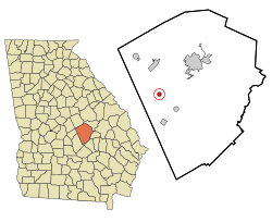
Dexter, Georgia | |
|---|---|
 Location in
Laurens County and the state of
Georgia | |
| Coordinates: 32°26′4″N 83°3′32″W / 32.43444°N 83.05889°W | |
| Country | United States |
| State | Georgia |
| County | Laurens |
| Area | |
| • Total | 0.79 sq mi (2.03 km2) |
| • Land | 0.77 sq mi (1.99 km2) |
| • Water | 0.02 sq mi (0.05 km2) |
| Elevation | 312 ft (95 m) |
| Population (
2020) | |
| • Total | 655 |
| • Density | 852.86/sq mi (329.50/km2) |
| Time zone | UTC-5 ( Eastern (EST)) |
| • Summer ( DST) | UTC-4 (EDT) |
| ZIP code | 31019 |
| Area code | 478 |
| FIPS code | 13-22752 [2] |
| GNIS feature ID | 0331543 [3] |
Dexter is a town in Laurens County, Georgia, United States. As of 2020, its population was 655.
History
The first permanent settlement at Dexter was made in 1889. [4] A post office has been in operation at Dexter since 1890. [5] The Georgia General Assembly incorporated the place in 1891 as the "Town of Dexter". [6]
Geography
Dexter is located in western Laurens County at 32°26′4″N 83°3′32″W / 32.43444°N 83.05889°W (32.434580, -83.058904). [7] Georgia State Route 257 is the town's Main Street; the highway leads northeast 12 miles (19 km) to Dublin, the county seat, and southwest 6 miles (10 km) to Chester. State Route 338 leads north 9 miles (14 km) to Dudley and south 7 miles (11 km) to Cadwell.
According to the United States Census Bureau, Dexter has a total area of 0.77 square miles (2.0 km2), of which 0.02 square miles (0.05 km2), or 2.31%, are water. [8] The town sits on a low ridge between Boggy Branch to the north and Stitchihatchie Creek to the south. Both streams flow northeast to Rocky Creek, part of the Oconee River watershed.
Demographics
| Census | Pop. | Note | %± |
|---|---|---|---|
| 1900 | 199 | — | |
| 1910 | 550 | 176.4% | |
| 1920 | 481 | −12.5% | |
| 1930 | 336 | −30.1% | |
| 1940 | 324 | −3.6% | |
| 1950 | 264 | −18.5% | |
| 1960 | 359 | 36.0% | |
| 1970 | 438 | 22.0% | |
| 1980 | 527 | 20.3% | |
| 1990 | 475 | −9.9% | |
| 2000 | 509 | 7.2% | |
| 2010 | 575 | 13.0% | |
| 2020 | 655 | 13.9% | |
| U.S. Decennial Census [9] | |||
| Race | Num. | Perc. |
|---|---|---|
| White (non-Hispanic) | 403 | 61.53% |
| Black or African American (non-Hispanic) | 223 | 34.05% |
| Asian | 2 | 0.31% |
| Other/Mixed | 22 | 3.36% |
| Hispanic or Latino | 5 | 0.76% |
As of the 2020 United States census, there were 655 people, 271 households, and 215 families residing in the town.
References
- ^ "2020 U.S. Gazetteer Files". United States Census Bureau. Retrieved December 18, 2021.
- ^ "U.S. Census website". United States Census Bureau. Retrieved January 31, 2008.
- ^ "US Board on Geographic Names". United States Geological Survey. October 25, 2007. Retrieved January 31, 2008.
- ^ Krakow, Kenneth K. (1975). Georgia Place-Names: Their History and Origins (PDF). Macon, GA: Winship Press. p. 62. ISBN 0-915430-00-2.
- ^ "Post Offices". Jim Forte Postal History. Retrieved April 22, 2018.
- ^ Acts and Resolutions of the General Assembly of the State of Georgia. Clark & Hines, State Printers. 1892. p. 685.
- ^ "US Gazetteer files: 2010, 2000, and 1990". United States Census Bureau. February 12, 2011. Retrieved April 23, 2011.
- ^ "U.S. Gazetteer Files: 2019: Places: Georgia". U.S. Census Bureau Geography Division. Retrieved December 11, 2019.
- ^ "Census of Population and Housing". Census.gov. Retrieved June 4, 2015.
- ^ "Explore Census Data". data.census.gov. Retrieved December 18, 2021.
