Historic Derby Street Neighborhood | |
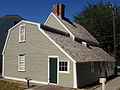
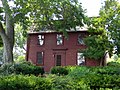
 Hawkes House | |
  | |
| Location | Salem, Massachusetts |
|---|---|
| Coordinates | 42°31′18″N 70°53′6″W / 42.52167°N 70.88500°W |
| Built | 1735 |
| Architectural style | Federal |
| NRHP reference No. | 76000297 [1] |
| Added to NRHP | May 17, 1976 |
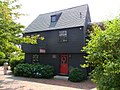
The Historic Derby Street Neighborhood, also known as the Derby Waterfront District in Salem, Massachusetts encompasses a historically significant portion of the waterfront area of the city. It encompasses properties along Derby Street, which parallels the waterfront, eastward from the Salem Maritime National Historic Site to its junction with Fort Avenue, and includes properties on the side streets between Derby and the waterfront. In addition to the National Historic Site, it includes the House of Seven Gables, a National Historic Landmark District. [2]
The district features Federal architecture and was added to the National Register of Historic Places in 1976. [1]
Gallery
-

-
-
 Salem Customs House - circa 1819
 -

-
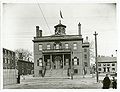 Custom House, ca. 1880
 -
-
 Salem - 1820
 -
 House of Seven Gables, 2015
 -
 Brookhouse Home, 2015
 -
 Captain William Allen House, 2015
 -
 Hooper-Hathaway House, 2015
 -
 Morning Glory Bed and Breakfast, 2015
 -
 Nathaniel Hawthorne's Birthplace, 2015
 -
 Penn Townsend House, 2015
 -
 Retire Beckett House, 2015
 -
 West India Goods Store, 2015


See also
- List of the oldest buildings in Massachusetts
- List of the oldest buildings in the United States
- List of historic houses in Massachusetts
- National Register of Historic Places listings in Salem, Massachusetts
- National Register of Historic Places listings in Essex County, Massachusetts
References
- ^ a b "National Register Information System". National Register of Historic Places. National Park Service. April 15, 2008.
- ^ "Derby Waterfront District". National Park Service. Retrieved January 9, 2014.
| Topics |  | ||||||||||||||||
|---|---|---|---|---|---|---|---|---|---|---|---|---|---|---|---|---|---|
| Lists by county | |||||||||||||||||
| Lists by city |
| ||||||||||||||||
| Other lists | |||||||||||||||||