Denmark, Mississippi | |
|---|---|
 Denmark  Denmark | |
| Coordinates: 34°18′39″N 89°20′48″W / 34.31083°N 89.34667°W | |
| Country | United States |
| State | Mississippi |
| County | Lafayette |
| Elevation | 472 ft (144 m) |
| Time zone | UTC-6 ( Central (CST)) |
| • Summer ( DST) | UTC-5 (CDT) |
| Area code | 662 |
| GNIS feature ID | 693083 [1] |
Denmark is an unincorporated community in Lafayette County, Mississippi, United States. Denmark is located near Mississippi Highway 6 10.6 miles (17.1 km) east-southeast of Oxford. [2] A post office operated under the name Denmark from 1872 to 1968. [3] In 1900, Denmark had a population of 75. [4]
References
- ^ "Denmark". Geographic Names Information System. United States Geological Survey, United States Department of the Interior.
- ^ Lafayette County, Mississippi General Highway Map (PDF) (Map). Mississippi Department of Transportation. 2008. Retrieved August 15, 2012.[ permanent dead link]
- ^ "Lafayette County". Jim Forte Postal History. Retrieved September 5, 2022.
- ^ Rowland, Dunbar (1907). Mississippi: Comprising Sketches of Counties, Towns, Events, Institutions, and Persons, Arranged in Cyclopedic Form. Vol. 1. Southern Historical Publishing Association. p. 641.
Municipalities and communities of
Lafayette County, Mississippi, United States | ||
|---|---|---|
| City | 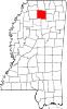 | |
| Towns | ||
| CDPs | ||
|
Other communities | ||
| Ghost town | ||
|
| This Lafayette County, Mississippi state location article is a stub. You can help Wikipedia by expanding it. |