De Haven, Virginia | |
|---|---|
 De Haven  De Haven | |
| Coordinates: 39°20′59″N 78°11′9″W / 39.34972°N 78.18583°W | |
| Country | United States |
| State | Virginia |
| County | Frederick |
| Time zone | UTC−5 ( Eastern (EST)) |
| • Summer ( DST) | UTC−4 (EDT) |
| GNIS feature ID | 1499329 [1] |
De Haven is an unincorporated community in northern Frederick County, Virginia. Originally known as Duck Race, De Haven sprang up as a farming community on Back Creek at its confluence with Babbs Run. De Haven is located on Green Spring Road (VA 671) at Hodges Lane (VA 741).
Historic sites
- Pine Grove School
- Pine Grove United Methodist Church
References
Municipalities and communities of
Frederick County, Virginia, United States | ||
|---|---|---|
| Towns | 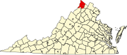 | |
| CDPs | ||
|
Other communities |
| |
This Frederick County, Virginia state location article is a stub. You can help Wikipedia by expanding it. |