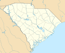
Darlington County Airport (Jetport) Hartsville Army Airfield | |||||||||||||||||||
|---|---|---|---|---|---|---|---|---|---|---|---|---|---|---|---|---|---|---|---|

Orthophoto from
USGS | |||||||||||||||||||
| Summary | |||||||||||||||||||
| Airport type | Public | ||||||||||||||||||
| Owner | Darlington County | ||||||||||||||||||
| Serves | Darlington, South Carolina | ||||||||||||||||||
| Elevation AMSL | 192 ft / 59 m | ||||||||||||||||||
| Coordinates | 34°26′58″N 79°53′24″W / 34.44944°N 79.89000°W | ||||||||||||||||||
| Map | |||||||||||||||||||
| Runways | |||||||||||||||||||
| |||||||||||||||||||
| Statistics (2011) | |||||||||||||||||||
| |||||||||||||||||||
Source:
Federal Aviation Administration
[1] | |||||||||||||||||||
Darlington County Airport (Jetport) ( ICAO: KUDG, FAA LID: UDG) is a county-owned, public-use airport located nine nautical miles (10 mi, 17 km) north of the central business district of Darlington, a city in Darlington County, South Carolina, United States. [1] It is included in the National Plan of Integrated Airport Systems for 2011–2015, which categorized it as a general aviation facility. [2] The airport does not have scheduled commercial airline service.
Although many U.S. airports use the same three-letter location identifier for the FAA and IATA, this facility is assigned UDG by the FAA but has no designation from the IATA. [3]
History
The airport was opened in October 1943. It was built by the United States Army Air Force, and known as Hartsville Army Airfield. It was used as an auxiliary training base for Florence Army Airfield, located 18 miles southeast. It was built as a bomber airfield, and supported A-20 Havocs, and later A-26 Invaders which were based at Florence. Its base unit was the 82nd Station Complement Squadron, which maintained the airfield and provided service to the aircraft.
Military use of the airfield ended early in 1945, and it was turned over to civil authorities which converted it into a civil airport.
From late 1978 to early 1979, the airport was the site of a major international drug smuggling operation run by a group of conspirators known as The Company. Early on the morning on January 17, 1979, 1380 pounds of marijuana arrived at the airport in a twin engine Cessna 404 Titan II aircraft reportedly traveling in from Colombia, South America. [4] Unbeknownst to the smugglers, the operation was being tracked by law enforcement agents. As the aircraft was being unloaded, agents converged on the airport and arrested fifteen individuals, including George Gedra, the airport manager and owner of the FBO, Gedra Air Service. Gedra reportedly arrived at the airport early that morning to open up the facilities for the smugglers and to turn on the runway lights for the landing Cessna. Police found Gedra hiding under the desk in his office. As he was being arrested, his telephone rang and the caller asked to speak to Gedra about a second load. [4]
Facilities and aircraft
Darlington County Airport (Jetport) covers an area of 635 acres (257 ha) at an elevation of 192 feet (59 m) above mean sea level. It has three asphalt paved runways: 5/23 is 5,500 by 100 feet (1,676 x 30 m); 10/28 is 4,947 by 150 feet (1,508 x 46 m); 16/34 is 4,751 by 150 feet (1,448 x 46 m). [1]
For the 12-month period ending April 21, 2011, the airport had 8,200 aircraft operations, an average of 22 per day: 93% general aviation, 6% air taxi, and 1% military. At that time there were 11 aircraft based at this airport: 82% single- engine and 18% jet. [1]
See also
References
- ^ a b c d FAA Airport Form 5010 for UDG PDF. Federal Aviation Administration. Effective April 5, 2012.
- ^ "2011–2015 NPIAS Report, Appendix A" (PDF). National Plan of Integrated Airport Systems. Federal Aviation Administration. October 4, 2010. Archived from the original (PDF, 2.03 MB) on September 27, 2012.
- ^ "Darlington County Jetport (ICAO: KUDG, FAA: UDG, IATA: none)". Great Circle Mapper. Retrieved June 20, 2010.
- ^ a b Greenhaw, Wayne (1984). Flying High. Dodd, Mead & Company. ISBN 0-396-08360-9.
 This article incorporates
public domain material from the
Air Force Historical Research Agency
This article incorporates
public domain material from the
Air Force Historical Research Agency- Manning, Thomas A. (2005), History of Air Education and Training Command, 1942–2002. Office of History and Research, Headquarters, AETC, Randolph AFB, Texas OCLC 71006954, 29991467
External links
- Aerial image as of February 1994 from USGS The National Map
- FAA Terminal Procedures for UDG, effective April 18, 2024
- Resources for this airport:
- FAA airport information for UDG
- AirNav airport information for KUDG
- ASN accident history for UDG
- FlightAware airport information and live flight tracker
- NOAA/NWS weather observations: current, past three days
- SkyVector aeronautical chart, Terminal Procedures

