The Danube Bend ( Hungarian: Dunakanyar) is a curve of the Danube in Hungary, close to the town of Visegrád.

Geology
The present-day U-shaped loop is probably the result of an eruption of the volcano stretching over the whole area some 15 million years ago. The caldera of Keserűs Hill-volcano, with the associated lava dome formed a later eroded central in the north. The river follows the southern edge of this caldera. [1]
The region
This region is touristically very significant. The landscape and the river attracts a lot of visitors both from the homeland and abroad. The most important towns are Visegrád, Szentendre and Budapest, while on the other (left) bank of the river can be found Vác, Nagymaros and some smaller towns, villages. The islands of the region are also interesting, mainly the large Szentendrei-sziget and Margaret Island (Margitsziget) within the capital city.
Gallery
-
 The Cathedral of Vác
 -
 Szentendrei-sziget
 -
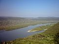
 The river near Visegrád
 -
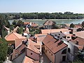 Szentendre
 -
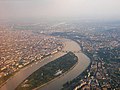 Margaret Island in Budapest


.jpg)

References
- ^ Karátson, Dávid (2015). "Danube Bend: Miocene Half-Caldera and Pleistocene Gorge". Landscapes and Landforms of Hungary. World Geomorphological Landscapes. Springer, Cham. pp. 129–137. doi: 10.1007/978-3-319-08997-3_16. ISBN 978-3-319-08996-6.
See also
47°47′57″N 19°05′30″E / 47.79917°N 19.09167°E
| International | |
|---|---|
| National | |
|
| This Hungarian geography article is a stub. You can help Wikipedia by expanding it. |