Dadia
Δαδιά | |
|---|---|
 Dadia | |
| Coordinates: 41°8′N 26°13′E / 41.133°N 26.217°E | |
| Country | Greece |
| Geographic region | Western Thrace |
| Administrative region | Eastern Macedonia and Thrace |
| Regional unit | Evros |
| Municipality | Soufli |
| Municipal unit | Soufli |
| Population (2021)
[1] | |
| • Community | 409 |
| Time zone | UTC+2 ( EET) |
| • Summer ( DST) | UTC+3 ( EEST) |
| Vehicle registration | EB |
Dadia (Greek: Δαδιά) is a village and a community in the northwestern part of the Evros regional unit, Eastern Macedonia and Thrace, Greece. Dadia is in the municipality of Soufli. Its population in 2021 was 409 for the community, including the village Kotronia. It is located southwest of Soufli and north of Feres. The name originates from a resinous pine wood which in the past was used for lighting.
Population
| Year | Village population | Community population |
|---|---|---|
| 1981 | 826 | - |
| 1991 | 737 | - |
| 2001 | 800 | 823 |
| 2011 | 533 | 546 |
| 2021 | 403 | 409 |
Geography
Dadia is situated on the western edge of the lower Evros valley, at the foot of wooded hills. Dadia Forest is a well known nature reserve, in which endangered species of birds of prey, including Aquila heliaca and Aquila pomarina, find refuge.
Gallery
-
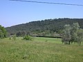 Dadia forest
 -
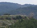
 Forest and hill
 -
 Dadia forest landscape
 -
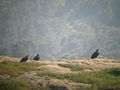
 Vultures on a hill crest
 -
 Track leading into the forest
 -
 Visitor centre
 -
 Local birds of prey
 -
 Closer view of local vultures
 -
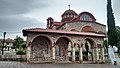 Church of Dadia


See also
References
- ^ "Αποτελέσματα Απογραφής Πληθυσμού - Κατοικιών 2021, Μόνιμος Πληθυσμός κατά οικισμό" [Results of the 2021 Population - Housing Census, Permanent population by settlement] (in Greek). Hellenic Statistical Authority. 29 March 2024.
External links
- The Dadia forest at the Greek WWF site (in Greek)