| Cutler Formation | |
|---|---|
| Stratigraphic range: | |
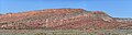
 Cutler Formation near the type locality, Portland,
Ouray County, Colorado | |
| Type | Geological formation |
| Sub-units |
De Chelly Sandstone, White Rim Sandstone, Organ Rock Shale, Cedar Mesa Sandstone, Elephant Canyon Formation, Halgaito Shale [1] [2] |
| Underlies |
Chinle Formation Moenkopi Formation |
| Overlies | Hermosa Group |
| Thickness | over 1,000 feet (300 m) |
| Lithology | |
| Primary | Iron-rich arkose sandstone |
| Location | |
| Coordinates | 38°05′46″N 107°42′07″W / 38.096°N 107.702°W |
| Approximate paleocoordinates | 0°42′N 36°06′W / 0.7°N 36.1°W |
| Region | Colorado Plateau |
| Country | United States |
| Extent |
Arizona Colorado New Mexico Utah |
| Type section | |
| Named for | Cutler Creek, north of Ouray, Co |
| Named by | Cross & Howe |
| Year defined | 1905 |
 Cutler Formation (the United States)  Cutler Formation (Colorado) | |
The Cutler Formation or Cutler Group is a rock unit that is exposed across the U.S. states of Arizona, northwest New Mexico, southeast Utah and southwest Colorado. It was laid down in the Early Permian during the Wolfcampian epoch.
Description
At its type area north of Ouray, Colorado, the Cutler Formation consists of over 1,000 feet (300 m) of bright red sandstone, siltstone, and conglomerate beds alternating with reddish mudstone or clay-rich limestone. [3] Further west, the unit shows great lithological diversity, and can be divided into easily recognizable mappable subunits. Here the Cutler is raised from formation to group rank and its subunits are themselves designated as formations. [4] The unit in its type area remains at formation rank and is often described as the "undifferentiated Cutler". [5] [6]
The formation overlies the Hermosa Group [6] and is in turn overlain by either the Dolores Formation (near its type area) [7] or the Moenkopi Formation (further west). [8] It is laterally equivalent to the Abo Formation of central New Mexico, to which it seamlessly transitions in the Jemez Mountains. [9]
The formation has been dated to Wolfcampian near its type area. [7] At this point in geologic time, the Uncompahgre Uplift of the Ancestral Rocky Mountains was still rising along an arc from eastern Utah through southwestern Colorado and into northern New Mexico. Tremendous quantities of sediment were eroded off the uplift and accumulated at its southwest margin to form the undifferentiated Cutler, which in some places reached a thickness of 8,000 feet (2,400 m). Further west, eolian (wind), fluvial (river) and marine influences became important and produced the lithological variety of the Cutler Group. [6]
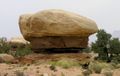
The undifferentiated Cutler consists of alluvial fan deposits in a narrow belt very close to the Uncompahgre Uplift, and fluvial deposits further out. The coarsest exposures are near Gateway, Colorado, within a mile of the thrust fault defining the southwest margin of the ancient Uncompahgre Uplift. Some granite boulders in these deposits are up to 25 feet (7.6 m) in diameter. [10] [11] However, thrusting along the uplift margin had ceased by the time the youngest beds were deposited. [12] Further west, the formation transitions to thin (less than 1 foot (0.30 m)) sandstone and conglomerate beds, in which the grains become finer towards the top of the bed (a fining upward sequence). These are interpreted as recording individual sheet flood events. [13]
Subunits
The Cutler has been placed at either formation or group stratigraphic rank, depending on the publication. Its subunits, therefore, are variously called formations or members. Subunits on the Colorado Plateau are: [11]
- De Chelly Sandstone (Arizona, Colorado, New Mexico, Utah) — youngest
- White Rim Sandstone (Utah)
- Organ Rock Shale (Arizona, Colorado, New Mexico, Utah)
- Cedar Mesa Sandstone (Arizona, Utah)
- lower Cutler beds (Arizona, Colorado, New Mexico, Utah) — oldest
Beds formerly assigned to the Elephant Canyon Formation, the Halgaito Shale, [14] or the Rico Formation are included in the lower Cutler beds. [15]
The stratigraphy of the lower Cutler beds has long been controversial. [14] [16] Charles Whitman Cross and A.C. Spencer applied the name Rico Formation to beds in the Rico Mountains of southwestern Colorado that were transitional from the marine Hermosa Formation and the overlying continental Cutler Formation. These contained marine fossils suggesting the beds covered the Pennsylvanian to Permian time interval. [17] The name came into wide use for transitional beds further west as petroleum geologists mapped the Colorado Plateau. [18] However, the definition of the Rico was vague and it was mapped inconsistently in the region. [19] This led Don Baars to recommend abandoning the Rico in favor of placing the upper, Permian beds in his new Elephant Canyon Formation and reassigning the lower, Pennsylvanian, beds to the underlying Honaker Trail Formation. [5] However, other geologists objected to this because the contact was defined by the fusulinids present in the beds, which made this a chronostratigraphic rather than a lithostratigraphic distinction, and by a subtle angular unconformity that was not easily recognized in the field. This led to abandonment of the Elephant Canyon Formation and designation of all beds between the Honaker Trail Formation and the Cedar Mesa Sandstone as simply the lower Cutler beds. These also include beds previously assigned to the Halgaito Formation. [16]
In the Chama Basin of New Mexico, the Cutler Group has been divided into two formations: [20]
- Arroyo del Agua Formation — younger
- El Cobre Canyon Formation — older
A sandstone unit resembling the De Chelly Sandstone is present above the Arroyo del Agua Formation in the southernmost part of the basin, but in this region it is assigned to the Yeso Group. [20]
Extent
Cutler outcrops are found in these geologic locations in Arizona, Colorado, New Mexico and Utah.
- Black Mesa Basin [21]
- Paradox Basin [21]
- Piceance Basin [22]
- San Juan Mountains province [3]
- San Juan Basin [9]
- Uinta Basin [22]
History of investigation
There is no designated type locality for the Cutler. It was named by Charles Whitman Cross and Ernest Howe in 1905 after Cutler Creek, which enters Uncompahgre River about 4 miles north of Ouray, Colorado. [23] They found that nonfossiliferous red beds provisionally assigned to the Dolores Formation were separated from overlying fossiliferous Triassic beds by a significant angular unconformity. The lower beds were tentatively identified as Permian beds, and were removed from the Dolores Formation to the newly designated Cutler Formation. [3]
Baker and Reeside revised Cross and Howe's work in 1929, tracing the Cutler across the Colorado Plateau and dividing the formation into the Halgaito Tongue, Cedar Mesa Sandstone Member, Organ Rock Tongue, and White Rim Sandstone Member. They also confirmed Cross and Howe's dating of the formation to the Permian. [21] The Cutler was traced through the Jemez Mountains and found to be laterally equivalent to the Abo Formation by Wood and Northrop in 1946. [9]
In 1958, Wengerd and Matheny raised the formation to group rank. [24]
-
 Cutler and Chinle formations in Lisbon Valley, San Juan County, Utah
 -
 Cedar Mesa Sandstone overlaying Organ Rock Shale, Canyonlands, Utah

References
- ^ "Geology of Canyonlands National Park" (PDF). National Park Service, U.S. Department of the Interior. Retrieved 30 September 2018.
- ^ "Stratigraphy of Canyon de Chelly National Monument". Geology of National Parks, 3D and Photographic Tours. United States Geological Survey. Archived from the original on 1 October 2018. Retrieved 30 September 2018.
- ^ a b c Cross, Whitman; Howe, Ernest; Ransome, F.L. (1905). "Description of the Silverton quadrangle [Colorado]". U.S. Geological Survey Geologic Atlas of the United States (120). doi: 10.3133/gf120. hdl: 1969.1/2953.
- ^ Fillmore, Robert (2010). Geological evolution of the Colorado Plateau of eastern Utah and western Colorado, including the San Juan River, Natural Bridges, Canyonlands, Arches, and the Book Cliffs. Salt Lake City: University of Utah Press. pp. 113–137. ISBN 9781607810049.
- ^ a b Baars, D.L. (1962). "Permian System of Colorado Plateau". AAPG Bulletin. 46 (2): 149–218. doi: 10.1306/BC74376F-16BE-11D7-8645000102C1865D.
- ^ a b c Fillmore 2010, p. 105.
- ^ a b Condon, S.M. (1992). "Geologic framework of pre-Cretaceous rocks in the Southern Ute Indian Reservation and adjacent areas, southwestern Colorado and northwestern New Mexico". U.S. Geological Survey Professional Paper. 1505-A. doi: 10.3133/pp1505A.
- ^ Stewart, J.H. (1959). "Stratigraphic Relations of Hoskinnini Member (Triassic?) of Moenkopi Formation on Colorado Plateau". AAPG Bulletin. 43 (8): 1852–1868. doi: 10.1306/0BDA5E73-16BD-11D7-8645000102C1865D.
- ^ a b c Wood, G.H.; Northrop, S.A. (1946). "Geology of the Nacimiento Mountains, San Pedro Mountain, and adjacent plateaus in parts of Sandoval and Rio Arriba Counties, New Mexico". Oil and Gas Investigations Map. 57. doi: 10.3133/OM57. Wikidata Q62639452.
- ^ MACK, GREG H.; RASMUSSEN, KEITH A. (1 January 1984). "Alluvial-fan sedimentation of the Cutler Formation (Permo-Pennsylvanian) near Gateway, Colorado". GSA Bulletin. 95 (1): 109–116. doi: 10.1130/0016-7606(1984)95<109:ASOTCF>2.0.CO;2.
- ^ a b Fillmore 2010, p. 107.
- ^ Moore, K.D.; Soreghan, G.S.; Sweet, D.E. (2008). "Stratigraphic and Structural Relations in the Proximal Cutler Formation of the Paradox Basin: Implications for Timing of Movement on the Uncompahgre Front". The Mountain Geologist. 45 (2): 49–68. Retrieved 16 February 2022.
- ^ Fillmore 2010, pp. 108–109.
- ^ a b Fillmore 2010, pp. 115–117.
- ^ Loope, David B.; Sanderson, George A.; Verville, George J. (October 1990). "Abandonment of the name "Elephant Canyon Formation" in southeastern Utah: Physical and temporal implications". The Mountain Geologist. 27 (4): 119–130. Retrieved 27 July 2021.
- ^ a b Condon, S.M. (1997). "Geology of the Pennsylvanian and Permian Cutler Group and Permian Kaibab Limestone in the Paradox Basin, southeastern Utah and southwestern Colorado". U.S. Geological Survey Bulletin. 2000-P. doi: 10.3133/b00P.
- ^ Cross, C.W.; Spencer, A.C. (1900). "Geology of the Rico Mountains, Colorado". U.S. Geological Survey Annual Report. 21 (2): 7–166. doi: 10.3133/ar21_2.
- ^ Wilmarth, M.G. (1938). "Lexicon of geologic names of the United States (including Alaska)". U.S. Geological Survey Bulletin. 896. doi: 10.3133/b896.
- ^ Wengerd, S.A.; Strickland, J.W. (1954). "Pennsylvanian Stratigraphy of Paradox Salt Basin, Four Corners Region, Colorado and Utah". AAPG Bulletin. 38. doi: 10.1306/5CEAE07C-16BB-11D7-8645000102C1865D.
- ^ a b Lucas, Spencer G.; Krainer, Karl (2005). "Stratigraphy and correlation of the Permo-Carboniferous Cutler Group, Chama Basin, New Mexico" (PDF). New Mexico Geologic Society Field Conference Series. 56: 145–159. Retrieved 9 July 2020.
- ^ a b c Baker, A.A.; Reeside, J.B. Jr. (1929). "Correlation of the Permian of Southern Utah, Northern Arizona, Northwestern New Mexico, and Southwestern Colorado". AAPG Bulletin. 13 (11): 1413–1448. doi: 10.1306/3D932893-16B1-11D7-8645000102C1865D.
- ^ a b Shoemaker, E.M.; Newman, W.L. (1959). "Moenkopi Formation (Triassic? and Triassic) in Salt Anticline Region, Colorado and Utah". AAPG Bulletin. 43 (8): 1835–1851. doi: 10.1306/0BDA5E70-16BD-11D7-8645000102C1865D.
- ^ Keroher, Grace C., Lexicon of Geologic Names of the United States for 1936-1960, Part 1, p. 1019, at Google Books
- ^ Wengerd, S.A.; Matheny, M.L. (1958). "Pennsylvanian System of Four Corners Region". AAPG Bulletin. 42 (9): 2048–2106. doi: 10.1306/0BDA5BA9-16BD-11D7-8645000102C1865D.
External links
- Cutler Formation
- Geologic formations of Arizona
- Geologic formations of Colorado
- Geologic formations of Utah
- Permian Arizona
- Permian Colorado
- Permian formations of New Mexico
- Permian geology of Utah
- Cisuralian Series of North America
- Sandstone formations of the United States
- Fluvial deposits
- Lacustrine deposits
- Permian northern paleotropical deposits
- Paleontology in Colorado
- Paleontology in New Mexico
- Paleontology in Utah