Cutervo | |
|---|---|
 Santo Tomás District (in the background), Toribio Casanova District (on the right) and
Marañón River as seen from near Tactago (
Cumba District,
Utcubamba Province) | |
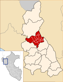
 Location of Cutervo in the
Cajamarca Region | |
| Country | Peru |
| Region | Cajamarca |
| Capital | Cutervo |
| Government | |
| • Mayor | Anibel Pedraza |
| Area | |
| • Total | 3,028.46 km2 (1,169.29 sq mi) |
| Population | |
| • Total | 142,533 |
| • Density | 47/km2 (120/sq mi) |
| UBIGEO | 0606 |
The Cutervo Province is one of the thirteen that make up the Cajamarca Region of Peru. [1] It is the home of the Cutervo National Park. It has a population of 162,686 and an area 3,028.46 square kilometers (1,169.29 sq mi).
Political division
It is divided into fifteen districts:
- Cutervo
- Callayuc
- Choros
- Cujillo
- La Ramada
- Pimpingos
- Querocotillo [2]
- San Andrés de Cutervo
- San Juan de Cutervo
- San Luis de Lucma
- Santa Cruz
- Santo Domingo de la Capilla
- Santo Tomás
- Socota
- Toribio Casanova
See also
References
- ^ "Health Alert: Updates to Government of Peru Quarantine and Movement Restrictions (April 16, 2021)". U.S. Embassy in Peru. 2021-04-16. Retrieved 2022-06-07.
- ^ "BNamericas - Improvement of the neighborhood road Santa T..." BNamericas.com. Retrieved 2022-06-07.

