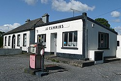
Curraghboy
An Currach Buí | |
|---|---|
Village | |
 Disused garage at Curraghboy | |
| Coordinates: 53°29′02″N 8°06′36″W / 53.484°N 8.110°W | |
| Country | Ireland |
| Province | Connacht |
| County | County Roscommon |
| Time zone | UTC+0 ( WET) |
| • Summer ( DST) | UTC-1 ( IST ( WEST)) |
Curraghboy ( Irish: An Currach Buí, meaning 'the yellow marsh') [1] is a rural village in County Roscommon, Ireland. It lies 14 km (8.7 mi) northwest of Athlone on the R362 regional road. It has one public house and two grocery shops. It also has an indoor handball alley, Roman Catholic church and a national (primary) school. [2]
See also
References
- ^ "An Currach Buí / Curraghboy". logainm.ie. Irish Placenames Commission. Retrieved 8 March 2020.
- ^ "Whole School Evaluation Report - Curraghboy National School, Curraghboy, Co. Roscommon" (PDF). education.ie. Department of Education. 6 March 2013. Retrieved 8 March 2020.

