Crary Mills, New York | |
|---|---|
| Coordinates: 44°34′59″N 75°4′7″W / 44.58306°N 75.06861°W | |
| Country | United States |
| State | New York |
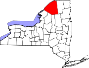
| County | St. Lawrence |
| Elevation | 479 ft (146 m) |
| Time zone | UTC-5 ( Eastern (EST)) |
| • Summer ( DST) | UTC-4 (EDT) |
| ZIP code | 13617 |
| Area code | 315 |
Crary Mills is a hamlet in St. Lawrence County, New York, United States. It consists of the southeastern corner of the Town of Canton and parts of the towns of Potsdam and Pierrepont.

