
Coyote Buttes is a section of the Paria Canyon-Vermilion Cliffs Wilderness managed by the Bureau of Land Management (BLM), spanning extreme south-central Utah and north-central Arizona, south of US 89 halfway between Kanab, Utah and Page, Arizona. It is divided into two areas: Coyote Buttes North and Coyote Buttes South. Visiting either of the Coyote Buttes areas requires purchasing a hiking permit.
The Coyote Buttes area is an exposure of cross-bedded aeolian Jurassic Navajo Sandstone. [1] The variable coloration of the sandstones is a result of various iron oxide pigments within the layers. A dinosaur trackway or trample surface is found in the area and provides evidence of a variety of dinosaurs. [1] The area includes dramatic swirling erosional rock formations such as The Wave.
The Wave and Buckskin Gulch share the Wire Pass Trailhead on House Rock Valley Road.
Dinosaur trackway
The dinosaur trackway within the area is a site of 0.75 acres (3,000 m2) that has densely packed dinosaur footprints within the area. The trackway contains more than 1,000 footprints which were made approximately 190 million years ago. [2] Tracks of three genera of Eubrontes, Anchisauripus and Grallator are present along with a Sauropodomorph that has not been identified. [1]
Gallery
-
 Coyote Buttes
 -
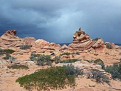 Coyote Buttes
 -
 The Wave
 -
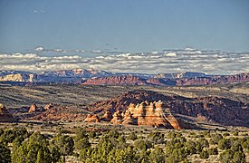 Looking north past the teepees, in Coyote Buttes South


References
- ^ a b c Seiler, W. M. (2008), Jurassic Navajo sandstone of Coyote Buttes, Utah/Arizona: coloration and diagenetic history, preservation of a dinosaur trample surface, and terrestrial analogs to Mars (MS Thesis), The University of Utah
- ^ "Scientists Discover 'Dinosaur Dance Floor'". The Washington Post. October 22, 2008. p. KidsPost.
External links
- "Coyote Buttes". Geographic Names Information System. United States Geological Survey, United States Department of the Interior.
- "Bureau of Land Management website". Archived from the original on 2012-04-13., with information on hiking permits
- "The Wave (Coyote Buttes)". SummitPost.org.
- Buttes of Arizona
- Buttes of the United States
- Mountains of Utah
- Rock formations of Utah
- Rock formations of Arizona
- Landforms of Coconino County, Arizona
- Landforms of Kane County, Utah
- Sandstone in the United States
- Jurassic Arizona
- Jurassic geology of Utah
- Kanab, Utah
- Colorado Plateau
- Bureau of Land Management areas in Arizona
- Bureau of Land Management areas in Utah
- Protected areas of Coconino County, Arizona
- Protected areas of Kane County, Utah