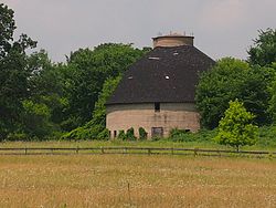
Cota Round Barns | |
 One of the Cota Round Barns from Benton County Highway 23 | |
| Nearest city | St. Cloud, Minnesota |
|---|---|
| Coordinates | 45°34′46″N 93°56′50″W / 45.57944°N 93.94722°W |
| Area | 3.5 acres (1.4 ha) |
| Built | 1921 |
| Built by | Cota, Al |
| MPS | Benton County MRA |
| NRHP reference No. | 82002936 [1] |
| Added to NRHP | April 6, 1982 |
The Cota Round Barns near St. Cloud, Minnesota, United States, are reinforced concrete round barns built in 1921. The set of barns was listed on the National Register of Historic Places in 1982. [1] According to a survey of Benton County historic resources, the Cota Round Barns are "a notable link" with the agricultural developments of 1880–1900 in the area. [2]
References
- ^ a b "National Register Information System". National Register of Historic Places. National Park Service. July 9, 2010.
- ^ "National Register of Historic Places Multiple Property Documentation: Benton County MRA". National Park Service.
Categories:
- Barns on the National Register of Historic Places in Minnesota
- Buildings and structures completed in 1921
- Buildings and structures in Benton County, Minnesota
- Round barns in Minnesota
- National Register of Historic Places in Benton County, Minnesota
- 1921 establishments in Minnesota
- Minnesota Registered Historic Place stubs

