Commonwealth Avenue | |
|---|---|
 | |
| Commonwealth Avenue, from Capital Hill | |
| General information | |
| Type | Highway |
| Length | 2.26 km (1.4 mi) |
| Route number(s) | (Civic–Capital Hill) |
| Former route number |
|
| Major junctions | |
| North end | Civic, Australian Capital Territory |
| |
| South end | Parliament Drive Capital Hill, Australian Capital Territory |
| Location(s) | |
| District | Canberra Central |
| Major suburbs | Civic, Acton, Parkes, Yarralumla, Capital Hill |
| Highway system | |
Commonwealth Avenue (route A23) is a major road in Canberra, Australian Capital Territory, Australia. It connects Civic with South Canberra. Specifically, it runs between City Hill and Capital Hill.
History
The first Commonwealth Avenue Bridge was constructed in 1928; that replaced a ford across the Molonglo River; and two earlier bridges. The current bridge was completed in 1963. [1] [2]
Description
Commonwealth Avenue is a six-lane-wide road with a wide median down the middle. The road crosses Lake Burley Griffin over the Commonwealth Avenue Bridge. The road is connected with Parkes Way by freeway style on-ramps. Along its length on the northern side are the Roman Catholic Archbishop's residence and Commonwealth Park. On the south side of the lake the road is lined with large trees and is bounded by the suburb of Parkes on the east and Yarralumla on the west. Significant sites along this stretch include the Albert Hall, the Hotel Canberra ( Hyatt) and the High Commissions of the United Kingdom, New Zealand and Canada.
Upon reaching Capital Hill, the road turns into Capital Circle which circles around Parliament House before connecting with Adelaide Avenue which connects it with Woden Valley. There is a ramp at the end of Commonwealth Avenue which allows access to Parliament House.
Between the spans on the southern side are four granite stones from the 1817 Waterloo Bridge across the River Thames in London, two at each end of the bridge. These were presented to Australia after the 1817 bridge was demolished in the 1940s and replaced by a modern structure. A plaque reads, in part, "Stones such as these from the bridge were presented to Australia and other parts of the British world to further historic links in the British Commonwealth of Nations."
Gallery
-
 Commonwealth Avenue crossing Lake Burley Griffin at Commonwealth Avenue Bridge
 -
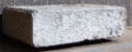 One of four granite stones from the 1817 Waterloo Bridge, London
 -
 The British High Commission building on Commonwealth Avenue


See also
References
- ^ Mildenhall, William James (1925). "Second Commonwealth Avenue Bridge" (image). ACT Heritage Library: ImagesACT. Government of the Australian Capital Territory. Retrieved 25 March 2020.
- ^ Ling, Ted, ed. (2013). "Expansion on a grand scale" (Part 1: Chapter 5). Government Records about the Australian Capital Territory. National Archives of Australia. Retrieved 25 March 2020.
| Controlled-access roads: | ||
|---|---|---|
| Limited-access roads: |
| |
| Bridges: | ||
| Major interchanges: | ||
| Related articles: | ||
*Partially limited-access ^Partially controlled-access roadway under construction | ||
|
| This article relating to the Australian Capital Territory is a stub. You can help Wikipedia by expanding it. |
|
| This Australian road or road transport-related article is a stub. You can help Wikipedia by expanding it. |