Coleman, Arkansas | |
|---|---|
 Coleman  Coleman | |
| Coordinates: 33°46′28″N 91°44′56″W / 33.77444°N 91.74889°W | |
| Country | United States |
| State | Arkansas |
| County | Drew |
| Elevation | 299 ft (91 m) |
| Time zone | UTC-6 ( Central (CST)) |
| • Summer ( DST) | UTC-5 (CDT) |
| Area code | 870 |
| GNIS feature ID | 56966 [1] |
Coleman is an unincorporated community in Drew County, Arkansas, United States. Coleman is located at the junction of Arkansas Highway 83 and Arkansas Highway 277, 10.3 miles (16.6 km) north-northeast of Monticello. [2] The Look See Tree, a lookout tree listed on the National Register of Historic Places, is located in Coleman.
References
- ^ a b U.S. Geological Survey Geographic Names Information System: Coleman, Arkansas
- ^ Drew County, Arkansas General Highway Map (PDF) (Map). Arkansas State Highway and Transportation Department. 2009. Archived from the original (PDF) on March 13, 2012. Retrieved February 16, 2013.
Municipalities and communities of
Drew County, Arkansas, United States | ||
|---|---|---|
| Cities | 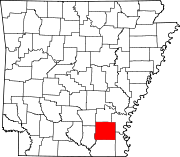 | |
| Towns | ||
| CDPs | ||
|
Other unincorporated communities | ||
| Footnotes | ‡This populated place also has portions in an adjacent county or counties | |
|
| This article about a location in Drew County, Arkansas is a stub. You can help Wikipedia by expanding it. |