Cleveland Run Township | |
|---|---|
 Location in Cheyenne County | |
| Coordinates: 39°56′14″N 101°47′52″W / 39.93722°N 101.79778°W | |
| Country | United States |
| State | Kansas |
| County | Cheyenne |
| Area | |
| • Total | 71.96 sq mi (186.37 km2) |
| • Land | 71.9 sq mi (186.21 km2) |
| • Water | 0.06 sq mi (0.16 km2) 0.09% |
| Elevation | 3,314 ft (1,010 m) |
| Population (
2000) | |
| • Total | 67 |
| • Density | 0.9/sq mi (0.4/km2) |
| GNIS feature ID | 0470846 |
Cleveland Run Township is a township in Cheyenne County, Kansas, USA. As of the 2000 census, its population was 67.
Geography
Cleveland Run Township covers an area of 71.96 square miles (186.4 km2) and contains no incorporated settlements. According to the USGS, it contains two cemeteries: Hackberry and Zion.
The stream of Valley Creek runs through this township.
References
External links
Municipalities and communities of
Cheyenne County, Kansas, United States | ||
|---|---|---|
| Cities | 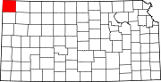 | |
|
Unincorporated communities | ||
| Townships | ||
|
| This article about a location in Cheyenne County, Kansas is a stub. You can help Wikipedia by expanding it. |