(Redirected from
Civic Center (Metrorail station))
| Metrorail metro station | |||||||||||||||
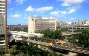
 View from the
University of Miami/Jackson Memorial Hospital medical complex and Metrorail train entering the station | |||||||||||||||
| General information | |||||||||||||||
| Location | 1501 NW 12th Avenue Miami, Florida | ||||||||||||||
| Coordinates | 25°47′23″N 80°12′54″W / 25.78972°N 80.21500°W | ||||||||||||||
| Owned by | Miami-Dade County | ||||||||||||||
| Platforms | 2 side platforms | ||||||||||||||
| Tracks | 2 | ||||||||||||||
| Connections | |||||||||||||||
| Construction | |||||||||||||||
| Accessible | Yes | ||||||||||||||
| Other information | |||||||||||||||
| Station code | CVC | ||||||||||||||
| History | |||||||||||||||
| Opened | December 17, 1984 [1] | ||||||||||||||
| Passengers | |||||||||||||||
| 2011 | 1.7 million
[2] | ||||||||||||||
| Services | |||||||||||||||
| |||||||||||||||
Civic Center station is a station on the Metrorail rapid transit system in the Health District of Miami, Florida. The station is located at the intersection of Northwest 12th Avenue ( State Road 933) and 15th Street. Civic Center provides a convenient connection for University of Miami medical students by connecting the hospital area to the main campus at University Station.
The station contains a branch of the Miami-Dade Public Library System. [3]
The station opened for service on December 17, 1984. [1]
Station layout
The station has two tracks served by side platforms. Entrances to the station are on either side of Northwest 12th Avenue, with fare control in a central mezzanine directly below the platform.
Places of interest
- Jackson Memorial Hospital
- University of Miami Miller School of Medicine
- Bascom Palmer Eye Institute
- Veterans Hospital
- LoanDepot Park (1 mile walk south)
- Miami-Dade County Jail
- Miami-Dade Justice Building/Courts
- Florida State Building
- Cedars Medical Center
- Miami-Dade County Health Department
- University of Miami Hospitals and Clinics
References
- ^
a
b
"Metrorail to Start Nighttime Service". Florida Today.
Cocoa, Florida. December 28, 1984. p. 6B. Retrieved September 18, 2023 – via Newspapers.com.

- ^ "(untitled)". Miami-Dade County.[ dead link]
- ^ "Civic Center Porta Kiosk Hours, Location, Events & Contact Info". Archived from the original on 2019-03-27. Retrieved 2020-09-05.
External links
-
 Media related to
Civic Center (Metrorail station) at Wikimedia Commons
 - MDT – Metrorail Stations
- entrance from Google Maps Street View
