33°20′24″S 115°38′31″E / 33.340°S 115.642°E
| City of Bunbury Western Australia | |||||||||||||||
|---|---|---|---|---|---|---|---|---|---|---|---|---|---|---|---|
 The Council building in 2007 | |||||||||||||||
 Location in
Western Australia | |||||||||||||||
|
| |||||||||||||||
| Population | 32,987 ( LGA 2021) [1] | ||||||||||||||
| Established | 1871 | ||||||||||||||
| Area | 65.7 km2 (25.4 sq mi) | ||||||||||||||
| Mayor | Jaysen de San Miguel | ||||||||||||||
| Council seat | Bunbury | ||||||||||||||
| Region | South West | ||||||||||||||
| State electorate(s) | Bunbury | ||||||||||||||
| Federal division(s) | Forrest | ||||||||||||||
|
| |||||||||||||||
| Website | City of Bunbury | ||||||||||||||
| |||||||||||||||
The City of Bunbury is a local government area in the South West region of Western Australia, covering an area of 65.7 square kilometres (25.4 sq mi) along the coast about 180 kilometres (112 mi) south of Perth, the capital of Western Australia. The City of Bunbury is one of four local governments comprising the Greater Bunbury urban area. As at the 2016 Census, the City of Bunbury had an estimated population of almost 32,000.
History
The Municipality of Bunbury was established on 21 February 1871. It absorbed part of the abolished Bunbury Road District, which had surrounded the municipality, on 20 January 1950, leading to the formation of a new Suburban Ward. It gained town status on 1 July 1961, becoming the Town of Bunbury, and assumed its current name when it was granted city status on 8 October 1979. [2]
Indigenous people
The City of Bunbury is located on the traditional land of the Wardandi (also spelled Wadandi) people, [3] [4] of the Noongar nation. [5]
Wards
The town has 12 councillors and no wards. Each councillor serves a four-year term, and half-elections are held every two years. The mayor is directly elected.
Twin towns and sister cities
The City of Bunbury has a sister/friendship city relationship with:
In 2009, Bunbury-Jiaxing Business Office was established to boost business opportunities between the two regions by assisting with communications and facilitating trade. [7]
Suburbs
The suburbs of the City of Bunbury with population and size figures based on the most recent Australian census: [8] [9]
| Locality | Population | Area | Map |
|---|---|---|---|
| Bunbury | 3,948 ( SAL 2021) [10] | 4.8 km2 (1.9 sq mi) |
|
| Carey Park | 5,155 ( SAL 2021) [11] | 4.1 km2 (1.6 sq mi) |
|
| College Grove | 1,821 ( SAL 2021) [12] | 5.7 km2 (2.2 sq mi) |
|
| Davenport | 8 ( SAL 2021) [13] | 11.7 km2 (4.5 sq mi) |
|
| East Bunbury | 4,019 ( SAL 2021) [14] | 3.5 km2 (1.4 sq mi) |
|
| Glen Iris | 3,143 ( SAL 2021) [15] | 4.9 km2 (1.9 sq mi) |
|
| Pelican Point | 929 ( SAL 2021) [16] | 2.4 km2 (0.93 sq mi) |
|
| Picton | 31 ( SAL 2021) [17] | 6 km2 (2.3 sq mi) |
|
| South Bunbury | 8,810 ( SAL 2021) [18] | 6.5 km2 (2.5 sq mi) |
|
| Usher | 2,137 ( SAL 2021) [19] | 3.9 km2 (1.5 sq mi) |
|
| Vittoria | 0 ( SAL 2021) [20] | 8.3 km2 (3.2 sq mi) |
|
| Withers | 2,979 ( SAL 2021) [21] | 4.4 km2 (1.7 sq mi) |
|
Population
|
|
Heritage-listed places
As of 2023, 336 places are heritage-listed in the City of Bunbury, [22] of which 46 are on the State Register of Heritage Places, among them the Old Bunbury railway station, St Patrick's Cathedral and the Rose Hotel. [23]
List of mayors
Gallery
-
 View west of the harbour from the lookout tower, August 2007
 -
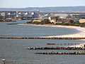 View north of the harbour from the lookout tower, August 2007
 -
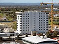 Wheat silos converted to residential apartments


References
- ^ Australian Bureau of Statistics (28 June 2022). "Bunbury (Local Government Area)". Australian Census 2021 QuickStats. Retrieved 28 June 2022.
- ^ "Municipality Boundary Amendments Register" (PDF). Western Australian Electoral Distribution Commission. Retrieved 11 January 2020.
- ^ "Wardandi". www.boodjar.sis.uwa.edu.au. University of Western Australia. Retrieved 13 September 2023.
- ^ "Wardandi (WA)". www.samuseum.sa.gov.au. South Australian Museum. Retrieved 13 September 2023.
-
^
"City of Bunbury: Home". www.bunbury.wa.gov.au.
City of Bunbury. Retrieved 13 September 2023.
The City of Bunbury acknowledge the traditional owners of the land, the Noongar Wardandi people ...
- ^ "International Relationships". City of Bunbury. Archived from the original on 24 April 2016. Retrieved 12 April 2016.
- ^ Verne, Ross (11 December 2013). "Bunbury-China ties celebrated". Bunbury Mail. Retrieved 12 April 2016.
- ^ "SLIP Map". maps.slip.wa.gov.au. Landgate. Retrieved 31 January 2023.
- ^ "NationalMap". nationalmap.gov.au. Geoscience Australia. Retrieved 31 January 2023.
- ^ Australian Bureau of Statistics (28 June 2022). "Bunbury (WA) (suburb and locality)". Australian Census 2021 QuickStats. Retrieved 28 June 2022.
- ^ Australian Bureau of Statistics (28 June 2022). "Carey Park (suburb and locality)". Australian Census 2021 QuickStats. Retrieved 28 June 2022.
- ^ Australian Bureau of Statistics (28 June 2022). "College Grove (suburb and locality)". Australian Census 2021 QuickStats. Retrieved 28 June 2022.
- ^ Australian Bureau of Statistics (28 June 2022). "Davenport (WA) (suburb and locality)". Australian Census 2021 QuickStats. Retrieved 28 June 2022.
- ^ Australian Bureau of Statistics (28 June 2022). "East Bunbury (suburb and locality)". Australian Census 2021 QuickStats. Retrieved 28 June 2022.
- ^ Australian Bureau of Statistics (28 June 2022). "Glen Iris (WA) (suburb and locality)". Australian Census 2021 QuickStats. Retrieved 28 June 2022.
- ^ Australian Bureau of Statistics (28 June 2022). "Pelican Point (WA) (suburb and locality)". Australian Census 2021 QuickStats. Retrieved 28 June 2022.
- ^ Australian Bureau of Statistics (28 June 2022). "Picton (WA) (suburb and locality)". Australian Census 2021 QuickStats. Retrieved 28 June 2022.
- ^ Australian Bureau of Statistics (28 June 2022). "South Bunbury (suburb and locality)". Australian Census 2021 QuickStats. Retrieved 28 June 2022.
- ^ Australian Bureau of Statistics (28 June 2022). "Usher (suburb and locality)". Australian Census 2021 QuickStats. Retrieved 28 June 2022.
- ^ Australian Bureau of Statistics (28 June 2022). "Vittoria (WA) (suburb and locality)". Australian Census 2021 QuickStats. Retrieved 28 June 2022.
- ^ Australian Bureau of Statistics (28 June 2022). "Withers (suburb and locality)". Australian Census 2021 QuickStats. Retrieved 28 June 2022.
- ^ "City of Bunbury Heritage Places". inherit.stateheritage.wa.gov.au. Heritage Council of Western Australia. Retrieved 25 February 2023.
- ^ "City of Bunbury State Register of Heritage Places". inherit.stateheritage.wa.gov.au. Heritage Council of Western Australia. Retrieved 25 February 2023.
External links
| International | |
|---|---|
| National | |