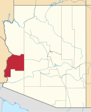
Cienega Springs, Arizona | |
|---|---|
 Location of Cienega Springs in La Paz County, Arizona | |
| Coordinates: 34°11′19″N 114°13′29″W / 34.18861°N 114.22472°W | |
| Country | United States |
| State | Arizona |
| County | La Paz |
| Area | |
| • Total | 3.85 sq mi (9.98 km2) |
| • Land | 3.55 sq mi (9.19 km2) |
| • Water | 0.30 sq mi (0.79 km2) |
| Elevation | 374 ft (114 m) |
| Population (
2020) | |
| • Total | 1,690 |
| • Density | 476.19/sq mi (183.88/km2) |
| Time zone | UTC-7 ( Mountain (MST)) |
| ZIP code | 85344
[2] |
| Area code | 928 |
| GNIS feature ID | 24372 [3] |
| FIPS code | 04-13540 |
Cienega Springs is a census-designated place in La Paz County, Arizona, United States. Its population was 1,690 as of the 2020 census.
Geography
The community is in northwestern La Paz County, along the Colorado River. It is bordered to the southwest by the community of Bluewater and to the northwest, across the river, by the state of California. Arizona State Route 95 mostly forms the southeast edge of the Cienega Springs CDP. The highway leads southwest 4.5 miles (7.2 km) to Parker, the La Paz county seat, and northeast 11 miles (18 km) to Parker Dam on the Colorado River, forming Lake Havasu.
According to the U.S. Census Bureau, the Cienega Springs CDP has a total area of 3.85 square miles (9.96 km2), of which 3.54 square miles (9.17 km2) are land and 0.31 square miles (0.79 km2), or 7.9%, are water. [4]
Utilities
Cienega Springs is served by the Cienga Water Company. [5]
Demographics
| Census | Pop. | Note | %± |
|---|---|---|---|
| 2020 | 1,690 | — | |
| U.S. Decennial Census [6] | |||
References
- ^ "2020 U.S. Gazetteer Files". United States Census Bureau. Retrieved October 29, 2021.
- ^ "Cienega Springs AZ ZIP Code". zipdatamaps.com. 2023. Retrieved February 17, 2023.
- ^ "Cienega Springs". Geographic Names Information System. United States Geological Survey, United States Department of the Interior.
- ^ "Geographic Identifiers: 2010 Census Summary File 1 (G001), Cienega Springs CDP, Arizona". American FactFinder. U.S. Census Bureau. Archived from the original on February 13, 2020. Retrieved August 15, 2019.
- ^ "Arizona Department of Environmental Quality, Drinking Water Watch".
- ^ "Census of Population and Housing". Census.gov. Retrieved June 4, 2016.


