This article needs additional citations for
verification. (April 2012) |
Cibubur | |
|---|---|
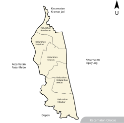
 Map of Ciracas district, and Cibubur within it | |
Location in
Java | |
| Coordinates: 6°21′25″S 106°52′55″E / 6.35694°S 106.88194°E | |
| Country | |
| Province | DKI Jakarta |
| Administrative city | East Jakarta |
| District | Ciracas |
| Government | |
| • Lurah (Village Head) | Agus Pramono, S.E |
| Area | |
| • Total | 4.50 km2 (1.74 sq mi) |
| Elevation | 75 m (246 ft) |
| Population (2017)
[4] | 74,412 |
| • Density | 16,536/km2 (42,830/sq mi) |
| Time zone | +7 |
Cibubur is one of the five administrative villages (kelurahan) in Ciracas district (kecamatan) in East Jakarta, Jakarta, the capital of Indonesia. [5] Cibubur is located in a strategic location, because it is between Jalan Raya Bogor and the Jonggol area. Cibubur is the site of an SOS Children's Village. [6]
Recreational Places
- Bumi Perkemahan dan Graha Wisata Pramuka (Buperta), a national Scouting center composed of camping grounds and other various recreational sites intended for activities ranging from elementary school level to nationwide Jamborees.
- Hutan Kota Cibubur
- Taman Bunga Widya Mandala Krida Bakti (Wiladatika), an interesting destination, perfect for family gatherings and recreational activities from swimming, Football, and other kinds of sports. It is also often visited by filmmakers to shoot movie scenes. [7]
- Telaga Arwana, a fun family spot with a lot of activities from educational activities, Swimming Pool, and a fishing spot that occasionally held tournaments to catch Arwana Fish. [8]
- Trans Studio Theme Park Cibubur, an indoor theme park located inside Trans Studio mall Cibubur, with 14 rides, including 2 roller coaster experiences.
References
- ^ Perangkat Daerah Provinsi DKI Jakarta Archived 2018-02-22 at the Wayback Machine (DKI Jakarta Province Regional Administrators)
- ^ "Ciracas in Figures". Area, Head of Family, Population and Their Density by Village. BPS Kota Administratif Jakarta Timur. 2017. Retrieved August 30, 2019.
- ^ "Ciracas in Figures". Distance Between Village Office to District Office and High Level from Sea Level. BPS Kota Administratif Jakarta Timur. 2016. Retrieved August 30, 2019.
- ^ "Ciracas in Figures". Area, Head of Family, Population and Their Density by Village. BPS Kota Administratif Jakarta Timur. 2017. Retrieved August 30, 2019.
- ^ Opschoor, J.B.; Button, K.J.; Nijkamp, P. (1999). Environmental Economics and Development. Edward Elgar Pub. p. 574. ISBN 9781858987408. Retrieved 2014-10-24.
- ^ "Indonesian Charity: Sponsor a child in Indonesia". soschildrensvillages.org.uk. Archived from the original on 2014-10-24. Retrieved 2014-10-24.
- ^ "TAMAN REKREASI WILADATIKA CIBUBUR". tamanwiladatika.com. Retrieved 2024-02-28.
- ^ "Daya Tarik Telaga Arwana Cibubur, Lokasi dan Harga Tiket Masuknya". Rumah123 (in Indonesian). Retrieved 2024-02-28.
