-
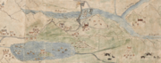 Chaksam ferry as depicted in this map from mid-1800s showing an iron chain bridge, a horse head ferry, and a yak-hide boat.
 -
 Diagram by an Indian spy working for the Survey of India in 1878
 -
 Chakzam Ferry as photoed by Ernst Schäfer in 1938
 -
 Qushui Yaluzangbujiang Bridge, the concrete bridge built by PRC replacing the Chushul Chakzam.
 -
 Ferry crossing in the 1930s
 -
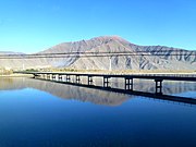
 Modern recreational ferry
Chushul Chakzam ཆུ་ཤུལ་ལྕགས་ཟམ | |
|---|---|
 Old Chain-Bridge at Chaksam. | |
| Coordinates | 29°19′38.31″N 90°41′9.56″E / 29.3273083°N 90.6859889°E |
| Crosses | Yarlung Tsangpo |
| Locale | Qüxü County, Lhasa Prefecture, Tibet Autonomous Region |
| Characteristics | |
| Design | Suspension bridge |
| Material | Iron suspension |
| Trough construction | Plank footway |
| Pier construction | Stone piers |
| Total length | 150 yards (140 m) [1] |
| Width | 30 centimetres (12 in) [2] |
| Height | 15 feet (4.6 m) [1] |
| History | |
| Designer | Thang Tong Gyalpo |
| Opened | 1430 |
| Closed | 1950s |
| Replaced by | Qushui Yaluzangbujiang Bridge |
| Location | |
|
| |
| Chushul Chakzam | |||||||
| Tibetan name | |||||||
|---|---|---|---|---|---|---|---|
| Tibetan | ཆུ་ཤུལ་ལྕགས་ཟམ | ||||||
| |||||||
| Chaksam Chuwori | |||||||
| Tibetan name | |||||||
|---|---|---|---|---|---|---|---|
| Tibetan | ལྕགས་ཟམ་ཆུ་བོ་རི | ||||||
| |||||||
The Chushul Chakzam ( Tibetan: ཆུ་ཤུལ་ལྕགས་ཟམ), or simply Chakzam which literally means "iron bridge" in Standard Tibetan, was a suspension bridge that spanned the Yarlung Tsangpo river in modern-day Qüxü County near Lhasa, Tibet. It was built in 1430 by Thang Tong Gyalpo. [3] The southern bridgehead was built on the mountain Chowuri, which is sacred in Tibetan Buddhism. This mountain was a site where Guru Rinpoche and Trisong Detsen had meditated during the 8th Century. [2] When it was built, its main section was the longest unsupported span in the world, with a central span estimated at around 150 yards (140 metres). [1]
In 1444, a monastery Chaksam Chuwori ( Tibetan: ལྕགས་ཟམ་ཆུ་བོ་རི) was founded on the southern bridgehead. [1] [2] During its existence, the monastery served as the seat of Chakzampa school of Tibetan Buddhism. [2] Supported by the bridge toll, the monastery at one point hosted about 100 monks. [4] The monastery was destroyed during the Cultural Revolution. [5]
History
By the 1860s, the bridge was in a state of disrepair that a ferry was in operation slightly upstream offering safer passage. [1] By 1904, the river had overflown the north bank leaving the northern bridgehead on an island, thus rendering the bridge functionally ineffective. [6] The ferryman mostly came from a nearby village of Chun or Junba, which is the only fishing village in Tibet. [7] [8] [9] The ferry service continued as late as 1959. [7]
During the Qing expedition to Tibet of 1910, the 13th Dalai Lama decided to seek refuge in India. His general Tsarong fought a skirmish against the Chinese here, holding their advances allowing the Dalai Lama to safely arrive in India. [10]
The bridge was torn down by the Chinese government in the 1950s when they were building the concrete bridge in its place. [2] The new concrete bridge Qushui Yaluzangbujiang Bridge opened on August 1, 1966. [11]

.png)


See also
References
- ^
a
b
c
d
e
Report on the Trans-Himalayan Explorations in Connection with the Great Trigonometrical Survey of India During 1865-67. 1867. p. 47.
we were rowed down the stream to Chusul village, passing Chaksam Chori village, which is situated on the right bank of the river, at foot of hill, and alongside an old bridge (formed of iron chain and rope), which owing to its insecurity, is seldom or never used, the ferries being preferable.
- ^
a
b
c
d
e Gerner, Manfred (2007).
Chakzampa Thangtong Gyalpo: Architect, Philosopher and Iron Chain Bridge Builder (PDF). Translated by Verhufen, Gregor. Centre for Bhutan Studies.
ISBN
978-99936-14-39-5.
(p12) This monastery is located at the holy mountain of Chuwo Ri (Chu bo ri), above the southern bridgehead of his iron chain bridge across the Yarlung Tsangpo river. Chuwo Ri is one of eight original meditation caves of Guru Rinpoche and the eighth century king of the Dharma, Trisong Detsen. (p32) In Tibet, the large monastery of Chakzam Chuwo Ri (lCags zam Chu bo ri) that Thangtong Gyalpo founded in 1444, located at the southern bridgehead of his famous 'Chakzam' across the Yarlung Tsangpo river, above its confluence with the Kyichu river (sKyid chu) became his main seat. Later, the monastery of Chakzam Chuwo Ri became the main monastery of the Chakzampa school as well as the seat of the Chakzampa Tulkus. (p83) Chinese engineers tore down this bridge during the construction of the new concrete bridge in about 1950 (p85) 30 centimetres wide
- ^ Dundul Namgyal Tsarong, Ani K. Trinlay Chödron, In the service of his country: the biography of Dasang Damdul Tsarong, commander general of Tibet, Snow Lion Publications, 2000, ISBN 1-55939-151-0, p. 26
-
^ Dowman, Keith (2008).
The Power-places of Central Tibet: The Pilgrim's Guide (PDF). Vajra Publications. p. 137.
ISBN
978-9937-506-04-5.
The 100 monks of this gompa were supported by the bridge toll.
-
^
Lungta. Amnye Machen Institute. 2001.
the monastery of Lcags zam Chu bo ri ... was destroyed during the Cultural Revolution.
-
^
Waddell, Lawrence Austine (1906). . New York: E.P. Dutton. pp. 312–313 – via
Wikisource.
(p312) bridge spans picturesquely the main stream of the river about 200 yards below the ferry, under the monastery which bears its name, "The holy hill of the Iron Bridge" (Chak-sam ch'ö-ri). ... it is not used at present, owing apparently to the river having burst for nearly half its waters a fresh channel to the north, and so having left the northern end of the bridge stranded amid-stream ... It is about 150 yards in length and 15 feet above flood-level ... (p313) The bridge was still in use in 1878
- ^
a
b Diana Lange (2015).
""The Boatman is more Beautiful than a God" Poetising and Singing on the Rivers in Central and Southern Tibet". The Illuminating Mirror. Tibetan Studies in Honour of per K. Soerensen on the Occasion of His 65th Birthday. Retrieved 21 January 2020 – via Academia.
Chaksam ferry station ... was served by villagers from the fishing village Chun ('Jun) during the entire year. Transport services along the route between Lhasa and Tsetang were also carried out by villagers. Chun is situated on the east bank of the southern part of the Kyichu, close to Chushur. It is the only village in Central Tibet where the inhabitants still live as fishermen.
-
^ Duan, Elaine (December 15, 2010).
"From legend to reality – a fishing village in Tibet". china.org.cn. Retrieved 21 January 2020.
In fact, Junba is the only fishing village in Tibet.
- ^ 日本旅宿小小咖 (2018-01-14). "西藏唯一的渔村, 因吃鱼而曾备受歧视, 连老婆都娶不到!" (in Chinese). Sina. Retrieved 21 January 2020.
-
^ Paul G. Hackett (1 May 2012).
Theos Bernard, the White Lama: Tibet, Yoga, and American Religious Life. Columbia University Press. p. 457.
ISBN
978-0-231-53037-8.
Dasang Damdul and his men followed the escape route taken by the Great Thirteenth's entourage--as did the Chinese force pursuing both of their parties--and at Chaksam Ferry four miles outside of Lhasa, decided to make a stand. ... Dasang Damdul would come to be known as the "Hero of Chaksam Ferry."
-
^ 常邦丽, ed. (2019-06-19).
"[西藏民主改革60周年专题展览 废奴丰碑]之八". tibetinfor.org. Retrieved 22 January 2020.
1966年8月1日,曲水雅鲁藏布江大桥建成通车。
External links
- lcags zam chu bo ri - Buddhist Digital Resource Center
|
| This Tibet-related article is a stub. You can help Wikipedia by expanding it. |
|
| This article about a specific bridge or group of bridges in China is a stub. You can help Wikipedia by expanding it. |