In May 2023, the incumbent Chippenham MP,
Michelle Donelan, announced she would be standing for the new
Melksham and Devizes constituency.[3] In July 2023, the local Conservative Association announced that their candidate for the new Chippenham constituency would be a local unitary councillor, Nic Puntis.[4]
History
A
parliamentary borough of Chippenham was enfranchised in 1295. It sent two
burgesses to Parliament until 1868 and one thereafter until the borough constituency was abolished in 1885. There was a
county division constituency named after the town of
Chippenham from 1885 to 1983, when the name of that constituency was changed to
North Wiltshire.
Following the
2003–2005 review into parliamentary representation in Wiltshire, the
Boundary Commission created a new county constituency, reviving the name of Chippenham as a seat. It is formed from parts of the previously existing
Devizes,
North Wiltshire and
Westbury constituencies.
Boundaries
Historical boundaries
Chippenham is the largest town in rural North Wiltshire and in the new constituency.
1295–1832: The
parliamentary borough of Chippenham in the unreformed Parliament consisted of only part of the parish of
Chippenham in
Wiltshire. However, as Chippenham was a
burgage borough, in which the right to vote was confined to the resident occupiers of specific properties, the boundary had no practical function. The borough had a population of 1,620 in 1831, for 283 houses.
1832–1885: The Boundary Act which accompanied the
Great Reform Act extended the boundaries of the parliamentary borough, to include the whole of Chippenham parish, the adjoining parishes of
Hardenhuish and
Langley Burrell, as well as the extra-parochial district of
Pewsham. This more than trebled the borough's population, to 5,270 by the 1831 figures, for 883 houses.
1885–1918: During this period, Wiltshire was split into five county divisions and one borough, of which The North-Western (or Chippenham) Division of Wiltshire was one; it was often colloquially referred to simply as either Chippenham or as North-West Wiltshire. It was bordered by the
Cricklade division to the east,
Westbury to the south and
Devizes to the southeast. Over the county boundary were
the Thornbury division of Gloucestershire to the west,
the Cirencester division of Gloucestershire to the north and
the Frome division of Somerset to the southwest.
The Chippenham division included the towns of
Calne and
Malmesbury as well as Chippenham, both of which had also been parliamentary boroughs in their own right before 1885. By the outbreak of World War I, the population of the constituency was about 45,000.
1950–1983: In the redistribution which took effect at the
1950 general election, Wiltshire was divided into one borough and four county constituencies. Chippenham County Constituency consisted of the same Municipal Boroughs as in 1918 and the Rural Districts of Calne and Chippenham, Cricklade and Wootton Bassett and Malmesbury.
From North Wiltshire: Cepen Park,
Chippenham Allington, Chippenham Audley, Chippenham
Avon, Chippenham Hill Rise, Chippenham London Road, Chippenham Monkton Park, Chippenham Park, Chippenham Pewsham, Chippenham Redland, Chippenham Westcroft/Queens,
Corsham,
Lacock with
Neston and
Gastard, Pickwick
From West Wiltshire: the wards of
Atworth and Whitley,
Bradford-on-Avon North, Bradford-on-Avon South, Holt, Manor Vale,
Melksham North, Melksham Spa, Melksham Without, Melksham Woodrow, Paxcroft
A map of Wiltshire shows the boundaries of the Chippenham seat, numbered 1.
Proposed changes
Further to the
2023 Periodic Review of Westminster constituencies, enacted by the Parliamentary Constituencies Order 2023, from the
next general election, due by January 2025, the constituency will be composed of the following electoral divisions of Wiltshire (as they existed on 4 May 2021):
Calne Central; Calne Chilvester & Abberd; Calne North; Calne Rural; Chippenham Cepen Park & Derriads; Chippenham Cepen Park & Hunters Moon; Chippenham Hardenhuish; Chippenham Hardens & Central; Chippenham Lowden & Rowden; Chippenham Monkton; Chippenham Pewsham; Chippenham Sheldon; Corsham Ladbrook; Corsham Pickwick; Corsham Without; Lyneham; Royal Wootton Bassett East; Royal Wootton Bassett North; Royal Wootton Bassett South & West.[5]
A petition was lodged in relation to the December 1910 election, but this was later withdrawn after a recount, resulting in the above numbers. The original count had placed the Conservatives with 4,139 votes and the Liberals with 4,113 votes.
^Brooke was initially declared elected in 1802, but on petition he was found not to have been duly elected and his opponent, Maitland, was declared elected in his place
^Foster, Bernard John (1966). "ISLINGTON, Sir John Poynder Dickson-Poynder". In
McLintock, A. H. (ed.).
Te Ara - the Encyclopedia of New Zealand. Ministry for Culture and Heritage / Te Manatū Taonga.
Archived from the original on 21 October 2012. Retrieved 30 March 2017.


 The northern portion of the former Westbury constituency was combined with...
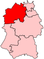 ...a southern portion of the North Wiltshire constituency, as well as...
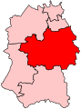 ...a small western portion of the Devizes constituency.
 A map of Wiltshire shows the boundaries of the Chippenham seat, numbered 1.


