Chemax | |
|---|---|
 Principal Church of Chemax | |
 Region 6 Oriente #019 | |
 Chemax Location of the Municipality in Mexico | |
| Coordinates: 20°35′00″N 87°33′00″W / 20.58333°N 87.55000°W | |
| Country | |
| State |
|
| Mexico Ind. | 1821 |
| Yucatán Est. | 1824 |
| Municipal seat | Chemax |
| Government | |
| • Type |
|
| • Municipal President | Lucio Balam Herrera [2] |
| Area | |
| • Total | 1,098.6 km2 (424.2 sq mi) |
| [2] | |
| Elevation | 26 m (85 ft) |
| Population (2010
[3]) | |
| • Total | 33,490 |
| Demonym | Chemaxeño |
| Time zone | UTC-6 ( Central Standard Time) |
| • Summer ( DST) | UTC-5 ( Central Daylight Time) |
| INEGI Code | 019 |
Chemax Municipality (IPA: [tʃeˈmaʃ], in the Yucatec Maya Language: “monkey's tree”) is a municipality in the Mexican state of Yucatán containing 1,098.6 km2 of land and located roughly 185 km east of the city of Mérida. [2]
History
There is no accurate data on when the town was founded, though it existed before the conquest as part of the province of Cupules. At colonization, Chemax became part of the encomienda system with the first encomendero noted in 1549 as Juan López de Mena. [2]
Yucatán declared its independence from the Spanish Crown in 1821 and during the Caste War of Yucatán the city was abandoned but repopulated after federal troops regained possession of it. [2] In 1865, the area was assigned to the partition of Valladolid Municipality. [4] In 1918, it was designated as its own municipality. [2]
Governance
The municipal president is elected for a three-year term. The town council has nine councilpersons, who serve as Secretary and councilors of public works, public lighting, police commissaries, public security, public monuments, nomenclature, ecology, and public sanitation. [5]
Communities
The head of the municipality is Chemax, Yucatán. There are 170 populated areas of the municipality [5] with the most important locations being: Además, Catzim, Chemax, Chen, Cocoyol, Kuxeb, Lolbé, Mucel, Punta Laguna, San Juan, San Pedro, Santa Cruz, Santa Elena, Sisbichén, Uspibil, Xalaú, X-Can, X-mab, X-maben, Xochmil, X-tejas and Xuneb. The significant populations are shown below: [2]
| Community | Population |
|---|---|
| Entire Municipality (2010) | 33,490 [3] |
| Chechmil | 478 in 2005 [6] |
| Chemax | 12764 in 2005 [7] |
| Chulután | 466 in 2005 [8] |
| Cocoyol | 522 in 2005 [9] |
| Kuxeb | 642 in 2005 [10] |
| Mucel | 900 in 2005 [11] |
| Sisbichen | 1566 in 2005 [12] |
| Uspibil | 764 in 2005 [13] |
| Xalau | 1813 in 2005 [14] |
| X-Can | 4653 in 2005 [15] |
| X-Catzin | 1757 in 2005 [16] |
-
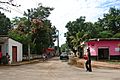 Chemax
 -
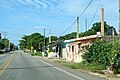
 Catzin
 -
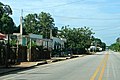
 X-Can
X-Can


Local festivals
- From 10 to 13 June, festival in honor of San Antonio de Padua, patron saint of the town of Chemax. [2]
Tourist attractions
- Churches of San Antonio de Padua, built in the sixteenth century
- Church of La Purísima Concepción, built in the seventeenth century
- Church of San Pedro, built in the seventeenth century
- Archaeological sites at Bolmay, Palaban, Petul, Poxil, Sotpol, Tamba, Xalau, Xcan, Xcoom, Xmaos and Xuyap
- Cenotes at Abli, Aktun Eek, Aktun Teel, Aktun Uspibil and Alamo I
Climate
Considered a tropical savanna climate typically with a pronounced dry season. The Köppen Climate Classification subtype for this climate is Aw (Tropical Savanna Climate). [17]
| Climate data for Chemax | |||||||||||||
|---|---|---|---|---|---|---|---|---|---|---|---|---|---|
| Month | Jan | Feb | Mar | Apr | May | Jun | Jul | Aug | Sep | Oct | Nov | Dec | Year |
| Mean daily maximum °C (°F) | 31 (87) |
31 (88) |
33 (91) |
34 (94) |
36 (96) |
35 (95) |
34 (94) |
34 (94) |
33 (92) |
33 (91) |
32 (89) |
31 (88) |
33 (92) |
| Mean daily minimum °C (°F) | 16 (61) |
17 (62) |
18 (64) |
19 (66) |
21 (70) |
22 (71) |
22 (71) |
21 (70) |
21 (70) |
20 (68) |
18 (65) |
18 (64) |
19 (67) |
| Average precipitation mm (inches) | 43 (1.7) |
56 (2.2) |
46 (1.8) |
38 (1.5) |
79 (3.1) |
150 (5.8) |
150 (5.8) |
170 (6.6) |
160 (6.2) |
140 (5.4) |
56 (2.2) |
51 (2) |
1,139 (44.3) |
| Source: Weatherbase [18] | |||||||||||||
References
- ^ "Denuncian despidos por 'venganza' de alcaldes" (in Spanish). Mérida, Mexico: gentepractika. 23 Apr 2015. Retrieved 2 August 2015.
- ^ a b c d e f g h "Municipios de Yucatán »Chemax" (in Spanish). Retrieved 2 August 2015.
- ^ a b "Mexico In Figures:Chemax, Yucatán". INEGI (in Spanish and English). Aguascalientes, México: Instituto Nacional de Estadística y Geografía (INEGI). Archived from the original on 6 May 2015. Retrieved 2 August 2015.
- ^ "Estado de Yucatán. División Territorial de 1810 a 1995" (PDF). inegi (in Spanish). Aguascalientes, Mexico: Instituto Nacional de Estadística, Geografía e Informática. 1996. Archived from the original (PDF) on 23 December 2015. Retrieved 2 August 2015.
- ^ a b "Chemax". inafed (in Spanish). Mérida, Mexico: Enciclopedia de Los Municipios y Delegaciones de México. Archived from the original on 4 July 2022. Retrieved 2 August 2015.
- ^ "Chechmil". PueblosAmerica (in Spanish). PueblosAmerica. 2005. Retrieved 2 August 2015.
- ^ "Chemax". PueblosAmerica (in Spanish). PueblosAmerica. 2005. Retrieved 2 August 2015.
- ^ "Chulután". PueblosAmerica (in Spanish). PueblosAmerica. 2005. Retrieved 2 August 2015.
- ^ "Cocoyol". PueblosAmerica (in Spanish). PueblosAmerica. 2005. Retrieved 2 August 2015.
- ^ "Kuxeb". PueblosAmerica (in Spanish). PueblosAmerica. 2005. Retrieved 2 August 2015.
- ^ "Mucel". PueblosAmerica (in Spanish). PueblosAmerica. 2005. Retrieved 2 August 2015.
- ^ "Sisbichen". PueblosAmerica (in Spanish). PueblosAmerica. 2005. Retrieved 2 August 2015.
- ^ "Uspibil". PueblosAmerica (in Spanish). PueblosAmerica. 2005. Retrieved 2 August 2015.
- ^ "Xalau". PueblosAmerica (in Spanish). PueblosAmerica. 2005. Retrieved 2 August 2015.
- ^ "X-Can". PueblosAmerica (in Spanish). PueblosAmerica. 2005. Retrieved 2 August 2015.
- ^ "X-Catzin". PueblosAmerica (in Spanish). PueblosAmerica. 2005. Retrieved 2 August 2015.
- ^ Climate Summary for Chemax
- ^ "Weatherbase.com". Weatherbase. 2013. Retrieved on July 14, 2013.
Mérida (capital) | |||||||||||||||
| Topics |  | ||||||||||||||
| Metros | |||||||||||||||
| Larger cities | |||||||||||||||
| Smaller cities |
| ||||||||||||||
| Municipalities |
| ||||||||||||||