
Chagulak Island (also spelled Chugul, Chugula, Chegoula, or Tchougoulok; [1] Russian: Чагулак) is a small, uninhabited volcanic island in the Islands of Four Mountains group in the Aleutian Islands of southwestern Alaska, United States. The 1.9 mi (3.1 km)-wide island consists of a single cone that reaches an elevation of 3,747 ft (1,142 m). Chagulak is a stratovolcano and is separated from the nearby Amukta Island by a channel about 4.3 miles (6.9 km) wide; though the two islands are joined underwater. No eruptions have been recorded and very little is known about the volcano, [2] as the only study done on Chagulak so far is a single chemical analysis of a "low-potassium, high-alumina basaltic andesite" from the north shore. [3]
Gallery
-
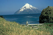 Chagulak Island, seen from Amukta Island
 -
 Closeup of Chagulak Island
 -
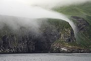 Coastal view with fog
 -
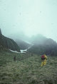 View of Chagulak Island field crew (1990)


References
-
^ Baker, Marcus (1906).
Geographic Dictionary of Alaska. Government Printing Office. p.
534. Retrieved 2008-09-01.
chagulak.
- ^ "Chagulak". Global Volcanism Program. Smithsonian Institution. Retrieved 2008-09-01.
- ^ "Chagulak Island description and information". avo.alaska.edu. Retrieved 2018-06-11.
52°34′20″N 171°08′29″W / 52.57222°N 171.14139°W
| National | |
|---|---|
| Geographic | |
| Other | |
|
| This article about a location in the Aleutians West Census Area, Alaska is a stub. You can help Wikipedia by expanding it. |