| Cedarburg Bog | |
|---|---|
 Map of
Wisconsin | |
| Location | Ozaukee County, Wisconsin, Wisconsin |
| Coordinates | 43°23′14″N 88°00′27″W / 43.38722°N 88.00750°W |
| Area | 2,200 acres (890 ha) |
| Designated | 1973 |
Cedarburg Bog is a bog located in Ozaukee County, Wisconsin owned by the Wisconsin Department of Natural Resources and the University of Wisconsin–Milwaukee. [1] It is the largest intact wetland complex in southeastern Wisconsin. [2] The bog is a refuge and habitat for several species of plantlife and wildlife. [3] It was designated a Wisconsin State Natural Area in 1952 and a National Natural Landmark in 1973. Additionally, it is part of the National Experimental Ecological Reserve Network. [4]
Photos
-
 Trailhead information boards
 -
 Lake at the end of the trail
 -
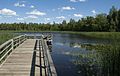 Pier on the lake


References
Wikimedia Commons has media related to
Cedarburg Bog.
- ^ "Cedarburg Bog (No. 2)". Wisconsin Department of Natural Resources. Retrieved 2012-01-19.
- ^ "Name: Cedarburg Bog". National Audubon Society. Archived from the original on 2012-07-23. Retrieved 2012-01-19.
- ^ "Cedarburg Bog". National Park Service. Retrieved 2012-01-19.
- ^ "Cedarburg Bog". University of Wisconsin-Milwaukee. Archived from the original on 2012-12-05. Retrieved 2012-01-19.
|
| This article about a location in Ozaukee County, Wisconsin is a stub. You can help Wikipedia by expanding it. |