| Cassiobridge
| |
|---|---|
 Ascot Road railway bridge | |
| Location | Watford |
| Local authority | Watford Borough Council |
| Managed by | London Underground |
| Number of platforms | 2 |
| London Underground annual entry and exit | |
| 2018 | Not opened [1] |
| 2019 | Not opened [2] |
| 2020 | Not opened [3] |
| 2021 | Not opened [4] |
| 2022 | Not opened [5] |
| Key dates | |
| 2020 [6] | Planned opening |
| Other information | |
| WGS84 | 51°39′04″N 0°25′27″W / 51.650993°N 0.424283°W |
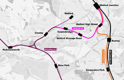
Cassiobridge was a proposed London Underground station in Watford, Hertfordshire, England. The station would have been part of the Croxley Rail Link project, a scheme to extend the Metropolitan line to Watford Junction railway station. It would have been served by Metropolitan line trains between Watford Junction and Central London via Baker Street. [7] The railway line would run over Ascot Road via a viaduct and the platforms would have been situated on the east side of the road. Entrance to the station would have been from the west side of the road, with a ticket hall and other facilities at street level. Passengers would gain access to the platforms via stairs and lifts and a short footbridge over the road. [8]
The station is projected to offer interchange with local transport services, [9] and operate as an unstaffed station, providing automatic ticketing facilities similar to a DLR station. There is potential for Park and Ride facilities to be provided, although planning documents indicate high levels of congestion on adjacent roads. [10] Watford station would close to passenger services, so that all trains from Croxley would continue to Watford Junction.
The railway and station had been expected to come into service in 2020 [6] [7] but on 25 January 2017, the Watford Observer newspaper published an update on the Croxley Rail Link confirming that work had stopped as there was an ongoing funding issue. [11]
Station name
Originally the station was to be called Ascot Road but some local people and councillors considered that this name would not reflect the identity of the area. Transport planners also expressed concern that the new tube station could be too easily confused with Ascot station in Berkshire. After some consultation on the names of the two new stations on the line, it was decided in August 2013 to use the name Cassiobridge instead, while the planned Watford Hospital station was changed to Watford Vicarage Road to be more recognisable outside the area. [12] [13]
Cassiobridge as a name has some historical provenance. There was a Cassiobridge Farm close to a bridge over the River Gade and nearby there is an early 19th-century timber house called Cassiobridge Lodge. These properties are linked with the former stately home of Cassiobury House and its estate, now the public Cassiobury Park, and the surrounding suburb of Cassiobury. [14] [15] The two modern bridges in the area now carry the A412 road over the Grand Union Canal and the River Gade. [13]
References
- ^ "Station Usage Data" (CSV). Usage Statistics for London Stations, 2018. Transport for London. 23 September 2020. Archived from the original on 14 January 2023. Retrieved 11 October 2023.
- ^ "Station Usage Data" (XLSX). Usage Statistics for London Stations, 2019. Transport for London. 23 September 2020. Archived from the original on 9 November 2020. Retrieved 9 November 2020.
- ^ "Station Usage Data" (XLSX). Usage Statistics for London Stations, 2020. Transport for London. 16 April 2021. Retrieved 1 January 2022.
- ^ "Station Usage Data" (XLSX). Usage Statistics for London Stations, 2021. Transport for London. 12 July 2022. Retrieved 7 September 2022.
- ^ "Station Usage Data" (XLSX). Usage Statistics for London Stations, 2022. Transport for London. 4 October 2023. Retrieved 10 October 2023.
- ^ a b "Metropolitan Line Extension". Transport For London - Improvements & projects. Archived from the original on 17 July 2017. Retrieved 9 January 2016.
- ^ a b "TWAO Submission January 2012". Croxley Rail Link. 6 January 2012. Archived from the original on 12 February 2012.
- ^ "Cassiobridge Station Ascot Road" (PDF). Hertfordshire County Council Development Management Section Head. Archived from the original (PDF) on 6 January 2015. Retrieved 6 January 2015.
- ^ "Watford Vision, Principles, Aims and Strategy - Chapter 4: Movement". Watford Borough Council. Archived from the original (PDF) on 8 December 2014. Retrieved 6 January 2015.
- ^ "DfT Expression of Interest - Submission for Funding" (PDF). Archived from the original (PDF) on 1 June 2011.
- ^ "UPDATE: Met Line extension: Mayor confirms work has stopped". 25 January 2017. Archived from the original on 31 March 2017. Retrieved 29 May 2017.
- ^ Wright, Mike (7 June 2013). "Names in the frame for new Croxley Rail Link stations in Watford". Watford Observer. Archived from the original on 7 June 2013.
- ^ a b Wright, Mike (22 July 2013). "Croxley Rail Link: Politicians lobby TFL over West Watford station name". Watford Observer. Archived from the original on 5 August 2013.
- ^ Rabbitts, Paul; Priestley, Sarah (2014). Cassiobury: The Ancient Seat of the Earls (Google eBook). Amberley Publishing Limited. ISBN 9781445638805. Archived from the original on 8 December 2015. Retrieved 31 October 2014.
- ^ "Cassio Bridge Lodge, Watford". British Listed Buildings. Archived from the original on 8 December 2015. Retrieved 5 January 2015.
External links
- "Planning Application Documents for Cassiobridge Station". Environment and planning. Watford Borough Council. Retrieved 10 January 2015.
- Croxley Rail Link from TfL
- Croxley Rail Link main website
| Abandoned Croxley Rail Link plan | ||||
|---|---|---|---|---|
| Preceding station |
|
Following station | ||
|
Watford Vicarage Road towards
Watford Junction
|
Metropolitan line Croxley Rail link
|
Croxley towards
Baker Street or
Aldgate
| ||


