| Carmel Bay | |
|---|---|
 | |
 Carmel Bay | |
| Location | Monterey County, California |
| Coordinates | 36°32′36″N 121°57′17″W / 36.54333°N 121.95472°W |
| River sources | Carmel River |
| Ocean/sea sources | Pacific Ocean |
| Basin countries | United States |
| Max. length | 4 miles (6.4 km) |
| Max. width | 2 miles (3.2 km) |
| Settlements | Carmel-by-the-Sea, California |
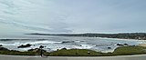
Carmel Bay is a bay of the Pacific Ocean, along the central coast of California in Monterey County. The bay is 4 mi (6.4 km) long and 2 mi (3.2 km) wide with its mouth about 3 mi (4.8 km) across, between Point Carmel to the south and Point Cypress to the north; Monterey Bay is about four coastline miles north, with Point Pinos intervening. [1]
The bay's coastline includes Carmel City Beach and Carmel River State Beach, with wildlife largely protected by the 'Carmel Bay Ecological Reserve'. The City of Carmel, formally "Carmel-by-the-Sea", adjoins Carmel Bay, with the cities of Monterey, Pacific Grove, California, and Santa Cruz about 5 mi (8.0 km), 4 mi (6.4 km), and 45 mi (72 km) north, respectively. [2]
Marine protected areas
Several areas in Carmel Bay have been designated marine protected areas under California's Marine Life Protection Act. ' Carmel Bay State Marine Conservation Area' (SMCA) is entirely underneath Carmel Bay, and both ' Carmel Pinnacles State Marine Reserve' (SMR) and ' Point Lobos State Marine Reserve' are partially underneath Carmel Bay. [3]
Along with the immediately adjoining ' Point Lobos State Marine Conservation Area', nearly 17 square miles (44 km2) [4] of marine protected areas in the waters in and around Carmel Bay are like underwater parks, helping to conserve ocean wildlife and marine ecosystems. [5] No living marine resources may be taken from these areas, except from 'Carmel Bay SMCA', and from there only recreational fishing for finfish and limited "by hand" commercial harvesting of giant kelp and bull kelp, by permit. [6]
Toponymy
The first Europeans to discover the bay were Spanish mariners led by Juan Rodriguez Cabrillo in 1542, sailing up the California coast without landing. In 1602, Spanish explorer Sebastián Vizcaíno named the nearby "Rio de Carmelo" to honor the three Carmelite priests on his expedition; the river empties into the bay, and so the names Carmelo and Carmel were later applied to the bay, a mission, the settlement, and other nearby features. [7]
Climate
The area around Carmel Bay experiences a cool summer Mediterranean climate ( Köppen climate classification Csb) typical of coastal areas of California. [8] The wet season is from October to May, and summers are often overcast, the sun blocked by marine layer clouds which can produce drizzle. September and October ( Indian Summer) offer the best weather of the year, with an average high of 72 °F. The average annual rainfall in Carmel-by-the-Sea is 15 inches per year and the average temperature is 57 degrees F. [9] [10]
| Climate data for Carmel-by-the-Sea | |||||||||||||
|---|---|---|---|---|---|---|---|---|---|---|---|---|---|
| Month | Jan | Feb | Mar | Apr | May | Jun | Jul | Aug | Sep | Oct | Nov | Dec | Year |
| Mean daily maximum °C (°F) | 15.6 (60.1) |
16.1 (61.0) |
17.8 (64.0) |
18.3 (64.9) |
19.4 (66.9) |
20.0 (68.0) |
21.1 (70.0) |
21.7 (71.1) |
21.1 (70.0) |
17.8 (64.0) |
16.7 (62.1) |
15.6 (60.1) |
18.4 (65.1) |
| Mean daily minimum °C (°F) | 6.1 (43.0) |
7.2 (45.0) |
8.3 (46.9) |
8.9 (48.0) |
10.0 (50.0) |
11.1 (52.0) |
11.7 (53.1) |
11.7 (53.1) |
10.6 (51.1) |
8.3 (46.9) |
7.8 (46.0) |
6.1 (43.0) |
9.0 (48.2) |
| Average precipitation mm (inches) | 106 (4.19) |
95 (3.75) |
90 (3.53) |
38 (1.48) |
13 (0.50) |
5.1 (0.20) |
2.3 (0.09) |
2.8 (0.11) |
7.1 (0.28) |
27 (1.06) |
62 (2.43) |
69 (2.73) |
517 (20.35) |
| Source: [11] | |||||||||||||
Gallery
-
 Carmel Bay on a foggy afternoon
 -
 Carmel Bay on a sunny afternoon
 -
 Carmel Bay from Carmel Point
 -
 Carmel Bay from Scenic Road


References
- ^ "An Offshore Description of the Big Sur Coast from George Davidson's "Coast Pilot" of 1889" by David Rogers, Double Cone Quarterly, Vol IV, Number 4, 2001, Ventana Wilderness Alliance
- ^ The Monterey Bay Shoreline Guide By Jerry Emory, University of California Press, 1999, pages 234,241-244
- ^ Guide to the Central California Marine Protected Areas (PDF), California Resources Agency, September 2007, archived from the original (PDF) on 2010-01-13, retrieved 2012-08-01, page 30
-
^ "Summary of Central Coast MPAs as Adopted by the California Fish and Game Commission, June 25, 2007", page 2, California Department of Fish and Game,
Retrieved 2012-07-06
Archived 2016-12-21 at the
Wayback Machine:
Carmel Bay SMCA (2.12 square miles)
Carmel Pinnacles SMR (0.53 square miles)
Point Lobos SMR (5.36 square miles)
Point Lobos SMCA (8.85 square miles) - ^ Guide to the Central California Marine Protected Areas (PDF), California Resources Agency, September 2007, archived from the original (PDF) on 2010-01-13, retrieved 2012-08-01
- ^ "Summary of Central Coast MPAs...June 25, 2007", page 5, California Department of Fish and Game, Retrieved 2012-07-06 Archived 2016-12-21 at the Wayback Machine
- ^ A Memorial and Biographical History of the Coast Counties of Central California by Luther A. Ingersoll, Lewis Publishing Company, 1893, page 17 [1]
- ^ Introduction to Physical Geography by Arthur Newell Strahler, Wiley, 1973, page 191
- ^ "Carmel-by-the-Sea Fact Sheet", Carmel Chamber of Commerce web site, Retrieved 2012-07-06, "Carmel enjoys moderately warm temperatures year round, with an average high of 65°F and an average low of 48°F. September and October (Indian Summer) offer the best weather of the year, with an average high of 72°F. Average rainfall, primarily between November and April, is 15 inches. Coastal fog is prevalent during the summer."
- ^ The Weather Channel web site, Retrieved 2012-07-06
- ^ "Carmel-by-the-Sea historic weather averages". Intellicast. Retrieved 12 February 2010.