Callantsoog | |
|---|---|
Village | |
 View on Callantsoog. | |
 Flag  Coat of arms | |
 Callantsoog Location in the Netherlands  Callantsoog Location in the province of North Holland in the Netherlands | |
| Coordinates: 52°50′N 4°42′E / 52.833°N 4.700°E | |
| Country | Netherlands |
| Province | North Holland |
| Municipality | Schagen |
| Area | |
| • Total | 22.17 km2 (8.56 sq mi) |
| Elevation | 1.2 m (3.9 ft) |
| Population (2021)
[1] | |
| • Total | 2,145 |
| • Density | 97/km2 (250/sq mi) |
| Time zone | UTC+1 ( CET) |
| • Summer ( DST) | UTC+2 ( CEST) |
| Postal code | 1759
[1] |
| Dialing code | 0224 |
Callantsoog ( West Frisian: Kallantsouge) is a village in the Dutch province of North Holland. It is a part of the municipality of Schagen, and lies about 18 km south of Den Helder. Callantsoog was a separate municipality until 1990, when it was merged with Zijpe. [3]
History
The village was first mentioned in the late 11th century as Callinge, and means "island of the people of Calle (person)". [4] The oldest settlement had been known to exist in 920, but was lost in the sea in 1170. The second settlement was built on the island 't Oghe and lasted until 1570. Shortly after, the third and current settlement was built further east. [5]
In the 1799 Battle of Callantsoog, the landing of 12 thousand British soldiers on the beaches north of the town launched the Anglo-Russian invasion of Holland, and triggered the mutiny or surrender of a squadron of Dutch warships.
The Dutch Reformed church is a double aisled church built between 1580 and 1581 using material from the flooded earlier church. It has a bell dating from 1491. [5]
Callantsoog was to 187 people in 1840. [6] During the early 20th century, Callantsoog started to develop as a tourist resort. In 1942, it became part of the Atlantic Wall. In 1943, a munition depot exploded destroying the houses near the sea. [5] It was an independent municipality until 1990 when it was merged into Zijpe. In 2013, it became part of the municipality of Schagen. [6]
Callantsoog has the oldest official nude beach of the country, dating from 1973. It is a sandy beach 1.5 kilometres (0.93 mi) to the south. [7]
Gallery
-
 Library of Callantsoog
 -
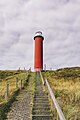 Lighthouse
 -
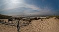 Beach view
 -
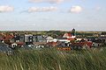 View from the dunes

.jpg)


References
- ^
a
b
c
"Kerncijfers wijken en buurten 2021". Central Bureau of Statistics. Retrieved 1 May 2022.
Minus Groote Keten & Abbestede
- ^ "Postcodetool for 1759GA". Actueel Hoogtebestand Nederland (in Dutch). Het Waterschapshuis. Retrieved 1 May 2022.
- ^ Ad van der Meer and Onno Boonstra, Repertorium van Nederlandse gemeenten, KNAW, 2011.
- ^ "Callantsoog - (geografische naam)". Etymologiebank (in Dutch). Retrieved 1 May 2022.
- ^ a b c Ronald Stenvert & Saskia van Ginkel-Meester (2006). "Callantsoog" (in Dutch). Zwolle: Waanders. Retrieved 1 May 2022.
- ^ a b "Callantsoog". Plaatsengids (in Dutch). Retrieved 1 May 2022.
- ^ "Nudist beach Callantsoog". naaktstrandje.nl. Retrieved 2016-03-06.
| Authority control databases: National |
|---|