Cáceres, Antioquia | |
|---|---|
Municipality and town | |
 | |
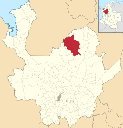
 Location of the municipality and town of Cáceres, Antioquia in the Antioquia Department of Colombia | |
| Coordinates: 7°40′N 75°20′W / 7.667°N 75.333°W | |
| Country | |
| Department | |
| Subregion | Bajo Cauca |
| Population (2015) | |
| • Total | 37,806 |
| Time zone | UTC-5 (Colombia Standard Time) |
Cáceres (Spanish pronunciation: [ˈkaseɾes]) is a town and municipality in the Colombian department of Antioquia.
Cáceres is one of the oldest towns in Antioquia. Its history is linked to the exploitation of gold. The town was founded in 1576 by Captain Don Gaspar de Rodas, who arrived on the banks of the Cauca River, advancing on the right bank. Once chosen the place, he ordered the installation of 30 ranches and with a very animated ceremony, that town received the name of San Martín de Cáceres.


