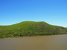
| Mount Taurus | |
|---|---|
| Bull Hill | |
 Bull Hill from
Storm King Mountain | |
| Highest point | |
| Elevation | 1,420 ft (430 m) [1] |
| Prominence | 680 ft (210 m) [2] |
| Listing | New York mountains |
| Coordinates | 41°26′18″N 73°57′20″W / 41.43833°N 73.95556°W [3] |
| Geography | |
| Location | North Highlands, New York |
| Parent range | Hudson Highlands |
| Topo map | West Point |
| Geology | |
| Mountain type | Precambrian igneous and metamorphic rocks [4] |
| Climbing | |
| Easiest route | Hike |
Bull Hill, also known as Mount Taurus, is a mountain north of the village of Cold Spring on the Hudson River in Putnam County in the State of New York. It is part of the river-straddling range known as the Hudson Highlands. The original name came after a bull that used to terrorize the mountain was chased by indignant inhabitants. [5] A hunting party drove the bull over the hill. In an attempt to flee the mountaineers, the bull plunged out into space and fell down. [6] Its broken and shapeless mass on the rocks was memorialized in the name of the mountain the bull used to haunt. [7]
While not as well known as neighboring Breakneck Ridge or Storm King Mountain across the river, it too is part of Hudson Highlands State Park and has an extensive trail system and offers hikers sweeping views of the river and neighboring peaks from rock outcrops [8] near its wooded 1,420-foot (433 m) summit, higher than both neighbors.
References
- ^ Arthur G. Adams (May 1981). The Hudson, a guidebook to the river. SUNY Press. p. 193. ISBN 978-0-87395-406-8. Retrieved 10 October 2011.
- ^ "Bull Hill - Peakbagger.com". Retrieved 2011-10-10.
- ^ "Bull Hill". Geographic Names Information System. United States Geological Survey. Retrieved 2013-01-10.
- ^ "Scenic Areas of Statewide Significance". Archived from the original on 2011-09-30. Retrieved 2011-10-10.
- ^ Joel Cook (1882). Brief summer rambles near Philadelphia: Described in a series of letters written for the Public ledger during the summer of 1881. J.B. Lippincott & co. p. 121. Retrieved 10 October 2011.
- ^ Blake, William J. (1849). The History of Putnam County, N.Y.: With an Enumeration of Its Towns, Villages, Rivers, Creeks, Lakes, Ponds, Mountains, Hills, and Geological Features. Baker & Scribner. p. 164.
- ^ Edgar Mayhew Bacon (1902). The Hudson River from ocean to source: historical--legendary--picturesque. G.P. Putnam's Sons. p. 357. Retrieved 10 October 2011.
- ^ "Bull Hill (Mt. Taurus) via Washburn/Notch/Brook/Cornish Trail Loop | New York-New Jersey Trail Conference". Nynjtc.org. 2005-05-20. Retrieved 2011-10-10.