-
 The "Cahal Grande" synagogue, located on 12 Negru Vodă Street.Built 1818 demolished 1985
 -
 The boulevard looking east from Piața Constituției
 -
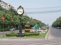
 The sidewalk area
 -
 The Palace of the Parliament as seen from Piața Unirii
 -
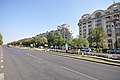 View along the boulevard
 -
 Looking west from Piața Alba Iulia at dusk
 View of the boulevard from the
Palace of the Parliament | |
 Shown within Bucharest | |
| Length | 2,800 m (9,200 ft) |
|---|---|
| Width | 92 m (302 ft) |
| Nearest metro station | Piața Unirii |
| Coordinates | 44°25′35″N 26°6′46″E / 44.42639°N 26.11278°E |
| From | Piața Constituției |
| To | Piața Alba Iulia |
Bulevardul Unirii (Romanian: [buleˈvardul uˈnirij], Union Boulevard) is a major thoroughfare in central Bucharest, Romania. It connects Constitution Square (Piața Constituției) with Alba Iulia Square (Piața Alba Iulia), and also runs through Union Square (Piața Unirii). The Constitution Square end features the Palace of the Parliament, which began construction simultaneously with the boulevard as an architectural unit.
History
Following the 1977 Vrancea earthquake, Bucharest's city center suffered significant damage, and a large number of historic buildings were demolished to make way for the new Centrul Civic (Civic Center). As part of the project, Bulevardul Unirii was to be Communist Romania's answer to Paris's Avenue des Champs-Élysées. Construction began on June 25, 1984. [1] Initially called Bulevardul Victoria Socialismului (Victory of Socialism Boulevard), the road is lined with apartment blocks and various public buildings of socialist-realism inspiration. [2]
Transport
The boulevard is served by Piața Unirii metro station at Union Square.
Gallery


.jpg)

See also
References
Wikimedia Commons has media related to
Bulevardul Unirii, Bucharest.
- ^ "Evenimente din 25 iunie, calendar istoric".[ permanent dead link]
- ^ "Rezistenta Urbana: Nomenclatorul Stradal: Partea III". Archived from the original on 2011-01-06. Retrieved 2011-02-11.
| Sectors of Bucharest |  | |
|---|---|---|
| Districts (quarters) |
| |
| Squares | ||
| Major streets | ||
| Hills | ||
| Rivers | ||
| Lakes | ||
| Parks and forests | ||
| See also | ||
| Operators |
| ||||||||||||||
|---|---|---|---|---|---|---|---|---|---|---|---|---|---|---|---|
| Mass transit |
| ||||||||||||||
|
|
| ||||||||||||||
|
|
| ||||||||||||||
|
|
| ||||||||||||||
|
| |||||||||||||||
|
|
| ||||||||||||||
44°25′35″N 26°06′46″E / 44.42639°N 26.11278°E
|
| This Romanian road or road transport-related article is a stub. You can help Wikipedia by expanding it. |