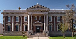
| Buhl City Hall | |
|---|---|
Buhl Village Hall | |
 Buhl City Hall viewed from the north-northeast | |
| Location | 300 Jones Avenue, Buhl, Minnesota |
| Coordinates | 47°29′44″N 92°46′40″W / 47.49556°N 92.77778°W |
| Area | Less than one acre |
| Built | 1913 |
| Built by | Bowe |
| Architect | Keith Architectural Services |
| Architectural style | Beaux-Arts |
| NRHP reference No. | 83000944 [1] |
| Added to NRHP | February 10, 1983 |
|
| |
Buhl City Hall is the seat of municipal government for Buhl, Minnesota, United States. It was built in 1913 during the city's rapid expansion as a mining community on the Iron Range. [2] It was listed as Buhl Village Hall on the National Register of Historic Places in 1983 for its local significance in the themes of architecture and politics/government. [3] It was nominated for being a well preserved early-20th-century Beaux-Arts municipal hall and Buhl's long-serving government center. [2]
See also
- List of city and town halls in the United States
- National Register of Historic Places listings in St. Louis County, Minnesota
References
- ^ "National Register Information System". National Register of Historic Places. National Park Service. July 9, 2010.
- ^ a b Roth, Susan; Charles Nelson (1982-11-12). National Register of Historic Places Inventory—Nomination Form: Buhl City Hall. National Park Service. Retrieved 2019-10-13. With two accompanying photos.
- ^ "Buhl Village Hall". Minnesota National Register Properties Database. Minnesota Historical Society. 2009. Retrieved 2019-08-11.
Categories:
- 1913 establishments in Minnesota
- Beaux-Arts architecture in Minnesota
- Buildings and structures in St. Louis County, Minnesota
- City and town halls on the National Register of Historic Places in Minnesota
- Government buildings completed in 1913
- National Register of Historic Places in St. Louis County, Minnesota


