Brusy | |
|---|---|
 | |
| Coordinates: 53°53′8″N 17°43′19″E / 53.88556°N 17.72194°E | |
| Country | |
| Voivodeship | Pomeranian |
| County | Chojnice |
| Gmina | Brusy |
| City rights | 1 January 1988 [1] |
| Government | |
| • Mayor | Witold Ossowski |
| Area | |
| • Total | 5.1 km2 (2.0 sq mi) |
| Population (30 June 2023
[2]) | |
| • Total | 5,103 |
| • Density | 1,000/km2 (2,600/sq mi) |
| Time zone | UTC+1 ( CET) |
| • Summer ( DST) | UTC+2 ( CEST) |
| Postal code | 89-632 |
| Vehicle registration | GCH |
| Website | http://brusy.pl/ |
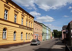
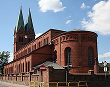
Brusy [ˈbrusɨ] ( Kashubian: Brusë; formerly German: Bruß) is a town in northern Poland, located in the Pomeranian Voivodeship. As of June 2023, the town has a population of 5,103. [2]
History

Brusy was a royal village of the Polish Crown, administratively located in the Tuchola County in the Pomeranian Voivodeship. [3]
Since the 19th century Brusy was an important center of the Kashub movement, although a fair amount of Kashubians from Brusy emigrated to Winona, Minnesota in the late 1900s. [4] In 2007, the ninth Congress of Kashubians was held here, and in 2012, the annual Kashubian Unity Day celebration was conducted here. A Kashubian secondary school is also located in the town.
During the German occupation of Poland ( World War II), inhabitants of Brusy were among over 450 Poles massacred by the Germans in autumn of 1939 in the Igielska Valley. [5] In November 1939 the SS, Gestapo and Selbstschutz murdered local Polish teachers in a large massacre of Polish teachers near Skarszewy. [6] Further executions of local Poles were carried out in January 1940 in the Igielska Valley and in the fields near Chojnice. [7] In May 1942, the Germans expelled dozens of Poles, whose farms were handed over to Germans as part of the Lebensraum policy. [8] The secret Polish resistance organization Pomeranian Griffin (Gryf Pomorski) operated in the Brusy area under the leadership of Colonel Józef Wrycza, who was also a Roman Catholic priest. The Germans set up a Waffen-SS training ground in the vicinity, and located its administration in Brusy. [9] Brusy was also the location of the Nazi German Bruss subcamp of the Stutthof concentration camp, in which around 500 female prisoners were held as forced labour. [10]
The town has obtained city rights on 1 January 1988. [1]
Notable people
- Stanisław Lamczyk (born 1957) a Polish politician, elected to the Sejm in 2005
- Piotr Piekarski (born 1964) a retired Polish 800 metres runner, participated in the 1992 Summer Olympics
- Jan Wyrowiński (born 1947) a Polish politician and Kashubian activist
See also
References
- ^ a b "Uchwała Rady Państwa z dnia 18 grudnia 1987 r. w sprawie utworzenia miasta Brusy w województwie bydgoskim (M.P. z 1987 r. nr 38, poz. 326)" (in Polish). Internetowy System Aktów Prawnych. Retrieved 2022-06-02.
- ^ a b "Local Data Bank". Statistics Poland. Retrieved 2022-06-02. Data for territorial unit 2202024.
-
^ Biskup, Marian; Tomczak, Andrzej (1955). Mapy województwa pomorskiego w drugiej połowie XVI w. (in Polish). Toruń. p. 123.
{{
cite book}}
: CS1 maint: location missing publisher ( link) - ^ "First Settlement in Winona: 1859 – Bambenek.org". bambenek.org. Retrieved 2017-07-21.
- ^ Wardzyńska, Maria (2009). Był rok 1939. Operacja niemieckiej policji bezpieczeństwa w Polsce. Intelligenzaktion (in Polish). Warszawa: IPN. p. 152.
- ^ Wardzyńska (2009), p. 153
- ^ Wardzyńska (2009), p. 182
- ^ Wardzyńska, Maria (2017). Wysiedlenia ludności polskiej z okupowanych ziem polskich włączonych do III Rzeszy w latach 1939-1945 (in Polish). Warszawa: IPN. pp. 120–121. ISBN 978-83-8098-174-4.
- ^ Wardzyńska (2017), p. 128
- ^ "Bruss-Sophienwalde (Brusy-Dziemiany)" (in German). Retrieved 31 March 2021.
External links


