-
 School in Bruiu
 -
 Romanian Orthodox Church in Bruiu
 -
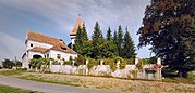
 Gherdeal and its fortified church
 -
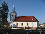
 Fortified church in Șomartin
Bruiu | |
|---|---|
 Fortified church in Bruiu | |
 Location in Sibiu County | |
 Bruiu Location in Romania | |
| Coordinates: 45°52′N 24°42′E / 45.867°N 24.700°E | |
| Country | Romania |
| County | Sibiu |
| Government | |
| • Mayor (2020–2024) | Emil Gherghel ( PNL) |
| Area | 97.09 km2 (37.49 sq mi) |
| Elevation | 442 m (1,450 ft) |
| Population (2021-12-01)
[1] | 671 |
| • Density | 6.9/km2 (18/sq mi) |
| Time zone | EET/ EEST (UTC+2/+3) |
| Postal code | 557065 |
| Area code | (+40) 02 69 |
| Vehicle reg. | SB |
| Website |
www |
Bruiu ( German: Braller; Hungarian: Brulya) is a commune located in Sibiu County, Transylvania, Romania. It is composed of three villages: Bruiu, Gherdeal (Gürteln; Gerdály), and Șomartin (Martinsberg; Mártonhegy). Each of these has a fortified church.
Geography
Situated on the Transylvanian Plateau, the commune lies on the banks of Pârâul Nou. It is located 60 km (37 mi) east of the county seat, Sibiu, on the border with Brașov County.
Architecture
Built by the local Transylvanian Saxon community, the village church was first attested in 1307. Initially built as a Romanesque basilica, it was transformed in the 15th century, when Gothic elements were added.
References
- Augustin Ioan, Hanna Derer. The Fortified Churches of the Transylvanian Saxons. Noi Media Print, 2004


|
| This Sibiu County location article is a stub. You can help Wikipedia by expanding it. |