Brooks County | |
|---|---|

Brooks County Courthouse in Quitman | |
 Location within the U.S. state of
Georgia | |
 Georgia's location within the
U.S. | |
| Coordinates: 30°43′44″N 83°42′54″W / 30.7289°N 83.715°W | |
| Country | |
| State | |
| Founded | December 11, 1858 |
| Named for | Preston Brooks |
| Seat | Quitman |
| Largest city | Quitman |
| Area | |
| • Total | 498 sq mi (1,290 km2) |
| • Land | 493 sq mi (1,280 km2) |
| • Water | 4.8 sq mi (12 km2) 1.0% |
| Population (
2020) | |
| • Total | 16,301 |
| • Density | 33/sq mi (13/km2) |
| Time zone | UTC−5 ( Eastern) |
| • Summer ( DST) | UTC−4 ( EDT) |
| Congressional district | 8th |
| Website |
www |
Brooks County is a county located in the U.S. state of Georgia, on its southern border with Florida. As of the 2020 census, the population was 16,301. [1] The county seat is Quitman. [2] The county was created in 1858 from portions of Lowndes and Thomas counties by an act of the Georgia General Assembly and was named for pro-slavery U.S. Representative Preston Brooks, after he severely beat abolitionist Senator Charles Sumner with a cane for delivering a speech attacking slavery.
In the peak lynching era, from 1880 to 1930, this county had 20 lynchings, the third-highest number of any county in Georgia, which was the state with the highest number of lynchings in the country. All of the victims in Georgia were black, including at least 13 killed in the May 1918 lynching rampage in this county, starting with the murders of Hayes Turner, and shortly after of his pregnant wife Mary Turner.
Brooks County is included in the Valdosta metropolitan statistical area.
History
Native Americans and the Spanish
Historic Native peoples occupying the area at the time of European encounter were the Apalachee and the Lower Creek. [3] The first Europeans in what is now Brooks County were Spanish missionaries from their colony in Florida, who arrived around 1570.
Early history
The area that was to become Brooks County was first opened up to European-American settlement in 1818 when Irwin County was established. Coffee Road was built through the region in the 1820s. Lowndes County's first court session was held at the tavern owned by Sion Hall on the Coffee Road, near what is now Morven, Georgia in Brooks County.
Establishment
This article needs additional citations for
verification. (February 2020) |
Many residents of Lowndes County were unhappy when the Atlantic and Gulf Railroad announced June 17, 1858, that they had selected a planned route that would bypass Troupville, the county seat. On June 22 at 3:00 am, the Lowndes County courthouse at Troupville was set aflame by William B. Crawford, who fled to South Carolina after being released on bond.
On August 9, a meeting convened in the academy building in Troupville, at which residents decided to divide Lowndes and create a new county to the west of the Withlacoochee River, to be called Brooks County.
On December 11, 1858, Brooks County was officially organized by the state legislature from parts of Lowndes and Thomas counties. It was named for Preston Brooks, a member of Congress prior to the Civil War. He was very popular in the South because of his 1856 caning of abolitionist senator Charles Sumner, and the citizens of Georgia wanted to honor him. Brooksville, Florida, and Brooksville, Virginia, also named or renamed themselves for Brooks.
The county had been developed along the waterways for cotton plantations, dependent on enslaved laborers, many of whom were transported to the South in the domestic slave trade during the Antebellum years. Cotton brought a high return from local and international markets, making large planters wealthy. At the time of the 1860 federal census, Brooks County had a white population of 3,067, a Free people of color population of 2, and a slave population of 3,282. The Atlantic and Gulf Railroad reached Quitman, the county seat, on October 23, 1860.
Civil War
During the Civil War, the county was the main producer of food for the Confederacy; it became known as the "Smokehouse of the Confederacy." [4]
Some Confederate Army regiments were raised from the men of Brooks County. Plantation owners, county officials, and slave patrol members were exempt from military conscription, which caused some contention between the different economic classes in Brooks County.

In August 1864, a local white man named John Vickery began plotting a slave rebellion. His plan called for killing the slave owners, stealing what weapons they could find, setting fire to Quitman, going to Madison, Florida, burning the town, getting help from Union troops from the Gulf Coast, and then returning to Quitman. On the evening before the rebellion, a slave was arrested for theft and interrogated. Vickery was soon arrested as well. Vickery and four slave suspects were given a military trial by the local militia. Two Confederate deserters from Florida were also believed to have been involved, but were not caught by the time of the trial. [5]
On August 23, 1864, at 6:00 p.m., Vickery, and slaves Sam, Nelson, and George were publicly hanged in Quitman. The court could not reach a decision on the guilt of Warren, a slave held by Buford Elliot. [5]
Post-Reconstruction and imposition of Jim Crow
After the war, many freedmen worked as sharecroppers or tenant farmers. Following the war and the Reconstruction era, Brooks County was one of the areas with a high rate of racial violence by whites against blacks. Its 20 deaths make it the county in Georgia that had the third-highest number of lynchings from 1870 to 1950. [6] (From 1880 to 1930, Georgia had the highest number of such extrajudicial murders in the country). [7] See, for example, the Brooks County race war of 1894.
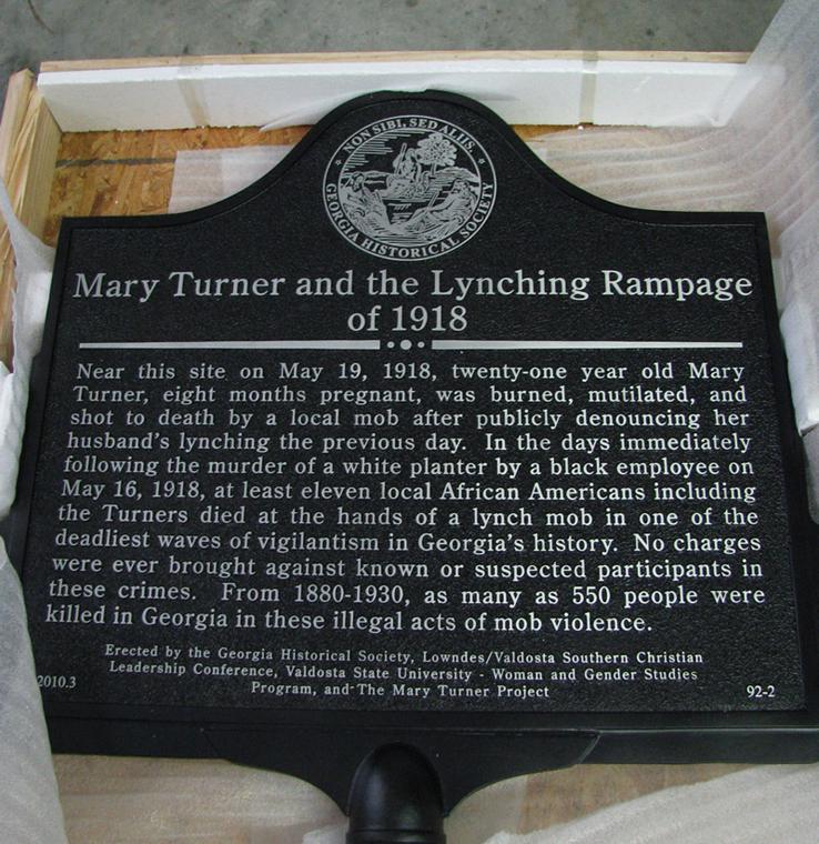
In May 1918, at least 13 African Americans were killed during a white manhunt and rampage after Sidney Johnson killed an abusive white planter. [8] Johnson had been forced to work for the man under the state's abusive convict lease system. Among those killed were Hayes Turner, and the next day his wife Mary Turner, who was eight months pregnant. They were the parents of two children. Mary Turner had condemned the mob's killing of her husband. She was abducted by the mob in Brooks County and brutally murdered at Folsom's Bridge on the Little River on the Lowndes County side; her unborn child was cut from her body and killed separately. During the next two weeks, at least another eleven blacks were killed by the mob. Johnson was killed in a shootout with police. As many as 500 African Americans fled Lowndes and Brooks counties to escape future violence. [9]
Mary Turner's lynching drew widespread condemnation nationally. It was a catalyst for the Anti-Lynching Crusaders campaign for the 1922 Dyer Bill, sponsored by Leonidas Dyer of St. Louis. It proposed to make lynching a federal crime, as southern states essentially never prosecuted the crimes. [10] The Solid South Democratic block of white senators consistently defeated such legislation, aided by having disenfranchised most black voters in the South. In 2010, a state historical marker, encaptioned "Mary Turner and the Lynching Rampage," was installed at Folsom's Bridge in Lowndes County to commemorate these atrocities.
Modern history
In the 21st century, Brooks County is classified as being in the Plantation Trace tourist region.
Historical sites
- The Brooks County Courthouse was constructed in 1864 in the county seat of Quitman, Georgia. It was designed by architect John Wind. Brooks County officials paid for the structure with $14,958 in Confederate money. The currency soon became useless.
- The Brooks County Museum and Cultural Center, formerly a library, was adapted for use as a cultural center. It is the site of a series of music, art, and culinary events throughout the year.
Geography
According to the U.S. Census Bureau, the county has a total area of 498 square miles (1,290 km2), of which 493 square miles (1,280 km2) is land and 4.8 square miles (12 km2) (1.0%) is water. [11]
The eastern boundary of the county is made up of the Little River (Withlacoochee River) and the Withlacoochee River, which together meander along a distance of over 100 miles (160 km) to form that boundary. These river boundaries are shared with Cook and Lowndes counties. The southern boundary of the county has a mutual east–west interface of about 25 miles (40 km) with Florida, although it is not continuous. The county is discontinuous along the Florida border, with the easternmost section about a mile east of the rest of the county. This section presently consists of one parcel, recorded as 350 acres (1.4 km2), although it has a border with Florida of almost 2 miles (3.2 km). The county shares a north–south boundary about 26 miles (42 km) in length with Thomas County to the west. It also shares an east–west boundary of 10 miles (16 km) and a north–south boundary of 3 miles (4.8 km) with Colquitt County to the northwest. The county has over 10,000 parcels of land, with 19 over 2,000 acres (8.1 km2) and two more than 5,000 acres (20 km2).
The county is home to several endangered plant and animal species, including the Pond Spicebush, the Wood Stork, and the Eastern Indigo snake.
The majority of Brooks County, including the northwestern portion, all of central Brooks County, and the southeastern corner, is located in the Withlacoochee River sub-basin of the Suwannee River basin. Most of the southern edge of the county is located in the Aucilla River sub-basin of the larger Aucilla- Waccasassa basin. The county's northeastern portion, centered on Morven and including Barney, is located in the Little River sub-basin of the same Suwannee River basin. [12]
Adjacent counties
- Cook County - northeast (created 1918 from Berrien County)
- Lowndes County - east (created 1825 from Irwin County)
- Madison County, Florida - southeast
- Jefferson County, Florida - southwest
- Thomas County - west (created 1825 from Early and Decatur counties)
- Colquitt County - northwest (created in 1856 from Thomas and Lowndes counties)
Communities
Cities
- Barwick (partly in Thomas County, Georgia)
- Morven
- Pavo (partly in Thomas County, Georgia)
- Quitman
Unincorporated communities
Demographics
| Census | Pop. | Note | %± |
|---|---|---|---|
| 1860 | 6,356 | — | |
| 1870 | 8,342 | 31.2% | |
| 1880 | 11,727 | 40.6% | |
| 1890 | 13,979 | 19.2% | |
| 1900 | 18,606 | 33.1% | |
| 1910 | 23,832 | 28.1% | |
| 1920 | 24,538 | 3.0% | |
| 1930 | 21,330 | −13.1% | |
| 1940 | 20,497 | −3.9% | |
| 1950 | 18,169 | −11.4% | |
| 1960 | 15,292 | −15.8% | |
| 1970 | 13,739 | −10.2% | |
| 1980 | 15,255 | 11.0% | |
| 1990 | 15,398 | 0.9% | |
| 2000 | 16,450 | 6.8% | |
| 2010 | 16,243 | −1.3% | |
| 2020 | 16,301 | 0.4% | |
| 2023 (est.) | 16,245 | [13] | −0.3% |
| U.S. Decennial Census
[14] 1790-1880 [15]1890-1910 [16] 1920-1930 [17] 1930-1940 [18] 1940-1950 [19] 1960-1980 [20] 1980-2000 [21] 2010 [22] | |||
| Race | Num. | Perc. |
|---|---|---|
| White | 9,066 | 55.62% |
| Black or African American | 5,684 | 34.87% |
| Native American | 24 | 0.15% |
| Asian | 67 | 0.41% |
| Pacific Islander | 6 | 0.04% |
| Other/Mixed | 499 | 3.06% |
| Hispanic or Latino | 955 | 5.86% |
As of the 2020 United States census, there were 16,301 people, 6,335 households, and 4,015 families residing in the county.
Racially and ethnically, as a result of the demand for slave labor to work the cotton plantations, the county was majority black from before the American Civil War well into the 20th century. Starting in the early 1900s, hundreds of blacks left the county in the Great Migration to northern and midwestern industrial cities to gain better opportunities and escape the oppressive Jim Crow conditions, including the highest rate of lynchings of blacks in Georgia from 1880 to 1930. [7] In 2020, its racial makeup was 55.62% non-Hispanic white, 34.87% African American, 0.15% Native American, 0.41% Asian, 0.04% Pacific Islander, 3.06% other, and 5.86% Hispanic or Latino of any race.
Education
The Brooks County School District offers pre-school to grade twelve. There are two elementary schools, a middle school and a high school, Brooks County High School. [24] The district has 167 full-time teachers and over 2,563 students. [25]
- North Brooks Elementary School
- Quitman Elementary School
- Brooks County Middle School
- Brooks County High School
The county is serviced by the Brooks County Public Library.
Government
The Government consists of a five-member Board of Commissioners. Under the guidelines of the Commissioners is a County Administrator, a Sheriff and Tax Commissioner, the Judicial System and other Boards and Authorities.
| Year | Republican | Democratic | Third party | |||
|---|---|---|---|---|---|---|
| No. | % | No. | % | No. | % | |
| 2020 | 4,261 | 60.01% | 2,791 | 39.30% | 49 | 0.69% |
| 2016 | 3,701 | 58.41% | 2,528 | 39.90% | 107 | 1.69% |
| 2012 | 3,554 | 52.62% | 3,138 | 46.46% | 62 | 0.92% |
| 2008 | 3,507 | 56.52% | 2,669 | 43.01% | 29 | 0.47% |
| 2004 | 2,912 | 56.91% | 2,193 | 42.86% | 12 | 0.23% |
| 2000 | 2,406 | 52.87% | 2,096 | 46.06% | 49 | 1.08% |
| 1996 | 1,738 | 42.87% | 1,977 | 48.77% | 339 | 8.36% |
| 1992 | 1,779 | 41.23% | 1,895 | 43.92% | 641 | 14.86% |
| 1988 | 2,136 | 58.54% | 1,500 | 41.11% | 13 | 0.36% |
| 1984 | 2,229 | 57.30% | 1,661 | 42.70% | 0 | 0.00% |
| 1980 | 1,546 | 40.40% | 2,230 | 58.27% | 51 | 1.33% |
| 1976 | 1,102 | 29.35% | 2,653 | 70.65% | 0 | 0.00% |
| 1972 | 2,430 | 79.08% | 643 | 20.92% | 0 | 0.00% |
| 1968 | 589 | 15.58% | 787 | 20.82% | 2,404 | 63.60% |
| 1964 | 2,342 | 69.50% | 1,027 | 30.47% | 1 | 0.03% |
| 1960 | 765 | 33.77% | 1,500 | 66.23% | 0 | 0.00% |
| 1956 | 534 | 21.62% | 1,936 | 78.38% | 0 | 0.00% |
| 1952 | 800 | 30.01% | 1,866 | 69.99% | 0 | 0.00% |
| 1948 | 188 | 11.21% | 975 | 58.14% | 514 | 30.65% |
| 1944 | 279 | 16.81% | 1,381 | 83.19% | 0 | 0.00% |
| 1940 | 248 | 16.01% | 1,300 | 83.93% | 1 | 0.06% |
| 1936 | 94 | 6.83% | 1,277 | 92.74% | 6 | 0.44% |
| 1932 | 75 | 4.98% | 1,426 | 94.69% | 5 | 0.33% |
| 1928 | 192 | 19.96% | 770 | 80.04% | 0 | 0.00% |
| 1924 | 128 | 9.69% | 1,179 | 89.25% | 14 | 1.06% |
| 1920 | 76 | 11.29% | 597 | 88.71% | 0 | 0.00% |
| 1916 | 25 | 2.28% | 969 | 88.33% | 103 | 9.39% |
| 1912 | 42 | 5.43% | 695 | 89.79% | 37 | 4.78% |
Recreation
Brooks County is well known for its wildlife. Quail, dove, ducks, and deer abound in the fields and forests. Brooks County also offers excellent fishing in its many lakes and streams, which are open to the public.
Hospital
Brooks County Hospital, a part of Archbold Medical Center, a 25-bed facility [27] was established in 1935 and has 24-hour emergency facilities.
Transportation
Major highways
Railroads
GA Bike Route 10
Georgia State Bicycle Route 10 is one of 14 bike routes across Georgia. Route 10 is 246 miles (396 km) long and goes from Lake Seminole in the west to Jekyll Island in the east. It runs a west–east route, of approximately 27.3 miles (43.9 km), through the county and passes through downtown Quitman.
Airport
BROOKS CO (4J5) Runway length 5000' Lights, CTAF 122.9 FSS Macon 122.4 [29]
See also
References
- ^ "Census - Geography Profile: Brooks County, Georgia". United States Census Bureau. Retrieved December 26, 2022.
- ^ "Find a County". National Association of Counties. Archived from the original on May 31, 2011. Retrieved June 7, 2011.
- ^ Huxford, Folks (1978). The History of Brooks County 1858-1948. p. 10. ISBN 0871522845.
- ^ History of Brooks County Georgia 1858-1948
- ^ a b Williams, David; Williams, Teresa Crisp; Carlson, David (2002). Plain Folk in a Rich Man's War: Class and Dissent in Confederate Georgia. Gainesville, Florida: University of Florida Press. pp. 144–150. ISBN 978-0813028361.
- ^ Lynching in America/ Supplement: Lynchings by County[ permanent dead link], 3rd Edition, 2015, p. 3
- ^ a b Meyers, Christopher C (2006). ""Killing Them by the Wholesale": A Lynching Rampage in South Georgia". The Georgia Historical Quarterly. 90 (2). JSTOR: 214–235. Retrieved May 14, 2013.
- ^ Gullberg, Greg (May 22, 2012). "South Georgia Citizens Fight To Keep Mary Turner's Story Alive". WCTV.
- ^ "Remembering Mary Turner". The Mary Turner Project. Retrieved March 30, 2014.
- ^ Armstrong, Julie. "Mary Turner and the Memory of Lynching". University of Georgia Press. Archived from the original on April 15, 2014. Retrieved March 30, 2014.
- ^ "US Gazetteer files: 2010, 2000, and 1990". United States Census Bureau. February 12, 2011. Retrieved April 23, 2011.
- ^ "Georgia Soil and Water Conservation Commission Interactive Mapping Experience". Georgia Soil and Water Conservation Commission. Archived from the original on October 3, 2018. Retrieved November 27, 2015.
- ^ "Annual Estimates of the Resident Population for Counties: April 1, 2020 to July 1, 2023". United States Census Bureau. Retrieved March 31, 2024.
- ^ "Decennial Census of Population and Housing by Decades". US Census Bureau.
- ^ "1880 Census Population by Counties 1790-1800" (PDF). US Census Bureau. 1880.
- ^ "1910 Census of Population - Georgia" (PDF). US Census Bureau. 1910.
- ^ "1930 Census of Population - Georgia" (PDF). US Census Bureau. 1930.
- ^ "1940 Census of Population - Georgia" (PDF). US Census Bureau. 1940.
- ^ "1950 Census of Population - Georgia -" (PDF). US Census Bureau. 1950.
- ^ "1980 Census of Population - Number of Inhabitants - Georgia" (PDF). US Census Bureau. 1980.
- ^ "2000 Census of Population - Population and Housing Unit Counts - Georgia" (PDF). US Census Bureau. 2000.
- ^ "State & County QuickFacts". United States Census Bureau. Archived from the original on June 7, 2011. Retrieved February 15, 2014.
- ^ "Explore Census Data". data.census.gov. Retrieved December 9, 2021.
- ^ Georgia Board of Education[ permanent dead link], Retrieved May 31, 2010.
- ^ School Stats, Retrieved May 31, 2010.
- ^ Leip, David. "Dave Leip's Atlas of U.S. Presidential Elections". uselectionatlas.org. Retrieved March 18, 2018.
- ^ "Brooks County Hospital (Quitman, GA) Detailed Hospital Profile". Hospital-data.com. Retrieved December 22, 2012.
-
^
"Archived copy" (PDF). Archived from
the original (PDF) on March 4, 2011. Retrieved February 17, 2010.
{{
cite web}}
: CS1 maint: archived copy as title ( link) - ^ "4J5 - Quitman Brooks County Airport". AirNav. Retrieved December 22, 2012.
External links
- Brooks County Board of Tax Assessors
- Brooks County Public Library
- Brooks County Criminal Court
- Brooks County historical marker
- Columbia Primitive Baptist Church historical marker
Places adjacent to Brooks County, Georgia | ||||||||||||||||
|---|---|---|---|---|---|---|---|---|---|---|---|---|---|---|---|---|
| ||||||||||||||||
Municipalities and communities of
Brooks County, Georgia, United States | ||
|---|---|---|
| Cities |  | |
| CDP | ||
|
Other unincorporated communities | ||
| Footnotes | ‡This populated place also has portions in an adjacent county or counties | |
| International | |
|---|---|
| National | |
| Other | |