-
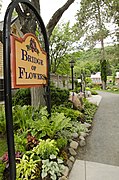 The entrance on the Shelburne Falls side of the bridge
 -
 A view from the center of the bridge, with the Deerfield River
 -
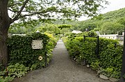 The entrance on the Buckland side of the bridge
Bridge of Flowers | |
|---|---|
 Bridge of Flowers, Shelburne Falls, Massachusetts | |
| Coordinates | 42°36′14.67″N 72°44′25.82″W / 42.6040750°N 72.7405056°W |
| Carries | pedestrians |
| Crosses | Deerfield River |
| Locale | Shelburne Falls, Massachusetts |
| Maintained by | Shelburne Falls Area Women's Club |
| Characteristics | |
| Design | Arch bridge |
| Total length | 400 ft (121 m) |
| Width | 18 ft (5 m) |
| History | |
| Designer | Edward S. Shaw |
| Opened | 1908 |
| Rebuilt | 1929, 1983 |
| Location | |
|
| |
The Bridge of Flowers is in Shelburne Falls, Massachusetts, connecting the towns of Shelburne and Buckland. The seasonal footbridge – once a trolley bridge – has a garden of flowers covering it. [1]
As a trolley bridge
Built for $20,000 in 1908 by the Shelburne Falls and Colrain Street Railway, so that freight could be picked up and dropped off directly from the railroads and brought to Colrain. [2] This concrete bridge was necessary because the nearby Iron Bridge had a twenty-ton weight limit. The Iron Bridge – a truss bridge built in 1890 – is still open to vehicles. [3] The two bridges' ends in Buckland are almost side by side.
As automobile usage began to increase, freight began to be transported more by trucks, and the street railway (trolley) company went bankrupt in 1927. The history of the railway is preserved in the Shelburne Falls Trolley Museum. [4] [5]
As a garden
In 1929, with the bridge covered in weeds, local housewife Antoinette Burnham came up with the idea of transforming the bridge into a garden. Since it was not needed as a footbridge and could not be demolished because it carried a water main between the two towns, the community agreed to her idea. The Shelburne Woman's Club sponsored the project in 1928. In 1929, eighty loads of loam and several loads of fertilizer were brought to the bridge. Several women's clubs around town raised $1,000 in 1929. [6]
In 1975, a photographic study was conducted of Shelburne Falls. One of the concerns of the town was the deterioration of the bridge structure. In 1981, funds were raised by those[ who?] who owned the bridge, and a study was commissioned. The study determined that $580,000 in repairs should be made to the bridge. Various organizations raised money and repairs began on May 2, 1983. During the restoration, every plant that was removed was cared for in private. [7] The restoration replaced the 8 inches (20 cm) water line, which carries up to half a million gallons of water a day. The bridge also contains two and a half feet of soil at the top of the arches and nine feet deep at the piers. [8]
On August 28, 2011, rain runoff from Hurricane Irene (at that point a tropical storm) flooded the Deerfield River and engulfed the Bridge of Flowers.[ citation needed]
The Bridge of Flowers


.jpg)
References
- ^ The Bridge of Flowers: From Ragweed to Roses: "The Bridge of Flowers is free of charge (donations are welcomed) and open daily — rain or shine — from April to October."
- ^ Bridge of Flowers turns 100 Archived 2016-09-18 at the Wayback Machine. The Republican. 18 September 2008.
- ^ Iron Bridge (Bridge Street Bridge / Shelburne Falls Bridge): Built 1890; rehabilitated 1994
- ^ "History Page". Shelburne Falls, Massachusetts: Bridge of Flowers Committee. 2010. Archived from the original on 18 August 2017. Retrieved 13 March 2010.
- ^ Beckius, Kim Knox (2010). "Bridge of Flowers: One-of-a-Kind Blooming Bridge is Shelburne Falls' Main Attraction". Shelburne Falls, Massachusetts: About.com. Archived from the original on 13 March 2017. Retrieved 15 March 2010.
- ^ Parmett, Elaine (2010). "History Page 2". Shelburne Falls, Massachusetts: Bridge of Flowers Committee. Archived from the original on 26 October 2010. Retrieved 13 March 2010.
- ^ "Restoration". Shelburne Falls, Massachusetts: Bridge of Flowers Committee. 2010. Retrieved 13 March 2010.
- ^ "Games/Fun Facts". Shelburne Falls, Massachusetts: Bridge of Flowers Committee. 2010. Archived from the original on 16 February 2010. Retrieved 13 March 2010.
External links
Wikimedia Commons has media related to
Bridge of Flowers.
Categories:
- Bridges completed in 1908
- Deck arch bridges in the United States
- Bridges in Franklin County, Massachusetts
- Tourist attractions in Franklin County, Massachusetts
- Railroad bridges in Massachusetts
- 1908 establishments in Massachusetts
- Shelburne, Massachusetts
- Buckland, Massachusetts
- Pedestrian bridges in Massachusetts
- Linear parks