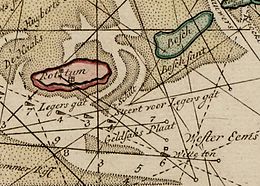
Rottum and Bosch, pre-1682 (
south at top) | |
|
| |
| Geography | |
|---|---|
| Coordinates | 53°30′35″N 6°23′38″E / 53.5097°N 6.3939°E |
| Archipelago | ( West) Frisian Islands |
| Adjacent to | North Sea, Wadden Sea |
| Administration | |
Bosch (Dutch pronunciation: [bɔs]) was a West Frisian island in the Wadden Sea. It was situated off the coast of present-day Groningen in the Netherlands, between the islands of Schiermonnikoog and Rottumeroog. [1]
Between 1400 and 1570 CE, the island Monnikenlangenoog had split into the islands Bosch and Rottumeroog. [2] Bosch disappeared in the Christmas Flood of 1717. [1] A shoal named Boschplaat was the remnant of the island, which merged into Rottumerplaat in 1959.
References
- ^ a b (in Dutch) Ellis Ellenbroek, " Bosch, vergeten Waddeneiland", Trouw, 2006. Retrieved on 2 May 2014.
- ^ (in Dutch) " Verzonken waddeneiland Moenkenlangenoe ontdekt Archived 2014-04-17 at archive.today", Dagblad van het Noorden, 2012. Retrieved on 25 January 2015.
