Borinquen | |
|---|---|
Barrio | |
 Mountain and homes in Borinquen | |
 Location of Borinquen within the municipality of Caguas shown in red | |
 Borinquen Location of Puerto Rico | |
| Coordinates: 18°10′12″N 66°02′26″W / 18.170086°N 66.040571°W [1] | |
| Commonwealth | |
| Municipality | |
| Area | |
| • Total | 6.27 sq mi (16.2 km2) |
| • Land | 6.27 sq mi (16.2 km2) |
| • Water | 0.00 sq mi (0.0 km2) |
| Elevation | 433 ft (132 m) |
| Population (2020) | |
| • Total | 7,251 |
| • Density | 1,200/sq mi (450/km2) |
| Source: 2020 Census | |
| Time zone | UTC−4 ( AST) |
| ZIP Code | 00725, 00726, 00727 |
| Area code(s) | 787, 939 |
Borinquen is a barrio in the municipality of Caguas, Puerto Rico. Its population in 2020 was 7,251. [3] [4]The barrio is named after the indigenous Taíno name for Puerto Rico, "Borinquen," which highlights the area's historical significance. [5]
History and demographics
Borinquen was in Spain's gazetteers [6] until Puerto Rico was ceded by Spain in the aftermath of the Spanish–American War under the terms of the Treaty of Paris of 1898 and became an unincorporated territory of the United States. In 1899, the United States Department of War conducted a census of Puerto Rico finding that the combined population of Borinquen barrio and Bairoa barrio was 3,870. [7]
| Census | Pop. | Note | %± |
|---|---|---|---|
| 1910 | 2,189 | — | |
| 1920 | 2,724 | 24.4% | |
| 1930 | 3,196 | 17.3% | |
| 1940 | 3,081 | −3.6% | |
| 1950 | 3,027 | −1.8% | |
| 1960 | 3,274 | 8.2% | |
| 1970 | 3,272 | −0.1% | |
| 1980 | 4,001 | 22.3% | |
| 1990 | 5,172 | 29.3% | |
| 2000 | 6,522 | 26.1% | |
| 2010 | 7,953 | 21.9% | |
| 2020 | 7,251 | −8.8% | |
| U.S. Decennial Census 1900 (N/A) [8] 1910-1930 [9] 1930-1950 [10] 1980-2000 [11] 2010 [12] 2020 [13] | |||
Places of interest
- Caguas Real Golf and Country Club, partially located in Borinquen. [14]
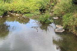
- Charco El Cantil, natural swimming pool on the Turabo River.
- Plaza Turabo, a riverside park located along the Turabo River.
- Terrazas de Borinquen Recreational Area, community pool and park.
Gallery
-
 Caguas Valley from Borinquen
 -
 Mountains near Borinquen
 -
 Charco El Cantil


See also
References
- ^ a b "US Gazetteer 2019". US Census. US Government.
- ^ U.S. Geological Survey Geographic Names Information System: Borinquen, Caguas, Puerto Rico
- ^ Picó, Rafael; Buitrago de Santiago, Zayda; Berrios, Hector H. Nueva geografía de Puerto Rico: física, económica, y social, por Rafael Picó. Con la colaboración de Zayda Buitrago de Santiago y Héctor H. Berrios. San Juan Editorial Universitaria, Universidad de Puerto Rico,1969.
- ^ Gwillim Law (20 May 2015). Administrative Subdivisions of Countries: A Comprehensive World Reference, 1900 through 1998. McFarland. p. 300. ISBN 978-1-4766-0447-3. Retrieved 25 December 2018.
- ^ PlaceDatabase. "Borinquen Barrio - Aguadilla". Place Database. Retrieved 2024-04-25.
- ^ "Anuario del comercio, de la industria, de la magistratura y de la administración. 1881". Biblioteca Nacional de España (in Spanish). p. 1614. Retrieved 4 April 2023.
- ^ Joseph Prentiss Sanger; Henry Gannett; Walter Francis Willcox (1900). Informe sobre el censo de Puerto Rico, 1899, United States. War Dept. Porto Rico Census Office (in Spanish). Imprenta del gobierno. p. 161.
- ^ "Report of the Census of Porto Rico 1899". War Department Office Director Census of Porto Rico. Archived from the original on July 16, 2017. Retrieved September 21, 2017.
- ^ "Table 3-Population of Municipalities: 1930 1920 and 1910" (PDF). United States Census Bureau. Archived (PDF) from the original on August 17, 2017. Retrieved September 21, 2017.
- ^ "Table 4-Area and Population of Municipalities Urban and Rural: 1930 to 1950" (PDF). United States Census Bureau. Archived (PDF) from the original on August 30, 2015. Retrieved September 21, 2014.
- ^ "Table 2 Population and Housing Units: 1960 to 2000" (PDF). United States Census Bureau. Archived (PDF) from the original on July 24, 2017. Retrieved September 21, 2017.
- ^ Puerto Rico: 2010 Population and Housing Unit Counts.pdf (PDF). U.S. Dept. of Commerce Economics and Statistics Administration U.S. Census Bureau. 2010. Archived (PDF) from the original on 2017-02-20. Retrieved 2019-08-02.
- ^ "Borinquen barrio, Caguas Municipio, Puerto Rico". US Census. Retrieved April 7, 2024.
- ^ "Caguas Real Golf & Country Club". Discover Puerto Rico. Retrieved October 21, 2021.
|
| This Caguas, Puerto Rico location article is a stub. You can help Wikipedia by expanding it. |